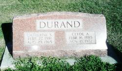
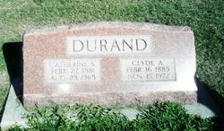
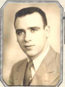
Clyde Able Durand
| Birth | : | 16 Feb 1885 Gresham, York County, Nebraska, USA |
| Death | : | 15 Nov 1972 Columbus, Platte County, Nebraska, USA |
| Burial | : | Saint Denis Catholic Cemetery, Fort Fairfield, Aroostook County, USA |
| Coordinate | : | 46.7773440, -67.8355030 |
frequently asked questions (FAQ):
-
Where is Clyde Able Durand's memorial?
Clyde Able Durand's memorial is located at: Saint Denis Catholic Cemetery, Fort Fairfield, Aroostook County, USA.
-
When did Clyde Able Durand death?
Clyde Able Durand death on 15 Nov 1972 in Columbus, Platte County, Nebraska, USA
-
Where are the coordinates of the Clyde Able Durand's memorial?
Latitude: 46.7773440
Longitude: -67.8355030
Family Members:
Parent
Spouse
Siblings
Children
Flowers:
Nearby Cemetories:
1. Saint Denis Catholic Cemetery
Fort Fairfield, Aroostook County, USA
Coordinate: 46.7773440, -67.8355030
2. Riverside Cemetery
Fort Fairfield, Aroostook County, USA
Coordinate: 46.7750015, -67.8060989
3. Harvey Hill Cemetery
McShea, Aroostook County, USA
Coordinate: 46.7567099, -67.8652997
4. Union Cemetery
Fort Fairfield, Aroostook County, USA
Coordinate: 46.7566150, -67.8655240
5. Haines Maple Grove Cemetery
Fort Fairfield, Aroostook County, USA
Coordinate: 46.7233160, -67.8699040
6. Greenridge Cemetery
Caribou, Aroostook County, USA
Coordinate: 46.7923622, -67.9321976
7. Our Lady of Mercy Cemetery
Aroostook, Victoria County, Canada
Coordinate: 46.7977210, -67.7263700
8. St. John The Evangelist Anglican Cemetery
Four Falls, Victoria County, Canada
Coordinate: 46.8278880, -67.7366425
9. Saint Ann Parish - Tobique First Nation Cemetery
Tobique, Victoria County, Canada
Coordinate: 46.7692510, -67.7055300
10. Bean Family Cemetery
Aroostook County, USA
Coordinate: 46.7396440, -67.9542600
11. Wark Cemetery
Perth-Andover, Victoria County, Canada
Coordinate: 46.7286569, -67.7205736
12. Saint Mary of the Angels
Perth-Andover, Victoria County, Canada
Coordinate: 46.7607665, -67.7018074
13. Presbyterian Rural Cemetery
Perth-Andover, Victoria County, Canada
Coordinate: 46.7600894, -67.7013150
14. Knight Cemetery
Fort Fairfield, Aroostook County, USA
Coordinate: 46.6876150, -67.8778140
15. Trinity Anglican Church Cemetery
Perth-Andover, Victoria County, Canada
Coordinate: 46.7571174, -67.6990229
16. Hillcrest Cemetery
Perth-Andover, Victoria County, Canada
Coordinate: 46.7431800, -67.7044100
17. Bubar Cemetery
Aroostook County, USA
Coordinate: 46.8399970, -67.9447840
18. Old Methodist Church Cemetery
Perth-Andover, Victoria County, Canada
Coordinate: 46.7506500, -67.6967900
19. Grimes Cemetery
Caribou, Aroostook County, USA
Coordinate: 46.8440386, -67.9420385
20. Perth-Andover Baptist Church Cemetery
Perth-Andover, Victoria County, Canada
Coordinate: 46.7478522, -67.6969303
21. Reuben Bean Family Cemetery
Aroostook County, USA
Coordinate: 46.7141610, -67.9514610
22. Larlee Creek Cemetery
Perth-Andover, Victoria County, Canada
Coordinate: 46.7147700, -67.7183500
23. Old Langley Cemetery
California Settlement, Victoria County, Canada
Coordinate: 46.8671210, -67.7631380
24. Pine Tree Cemetery
Easton, Aroostook County, USA
Coordinate: 46.6774640, -67.8727940

