
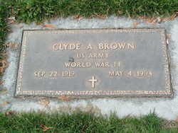
Clyde Arthur Brown
| Birth | : | 22 Sep 1919 Tyrone, Texas County, Oklahoma, USA |
| Death | : | 4 May 1994 Wenatchee, Chelan County, Washington, USA |
| Burial | : | Saint Stephens Cemetery, Bridgewater, McCook County, USA |
| Coordinate | : | 43.5574989, -97.4766998 |
| Description | : | EAST WENATCHEE - Clyde A. Brown, 74, a resident of East Wenatchee for 28 years, died Wednesday, May 4, 1994, in Central Washington Hospital. He was born Sept. 22, 1919, to William Henry and Idella Mae (Bodine) Brown at Tyrone, Okla. He spent his early years in Oklahoma, Texas and Arizona, before moving with his family to the Yakima Valley in the mid-1930s. He attended Cowiche High School where he played baseball. Following high school, he joined the National Guard. He transferred to the U.S. Army in March of 1941. He served during World War II in the South Pacific with the... Read More |
frequently asked questions (FAQ):
-
Where is Clyde Arthur Brown's memorial?
Clyde Arthur Brown's memorial is located at: Saint Stephens Cemetery, Bridgewater, McCook County, USA.
-
When did Clyde Arthur Brown death?
Clyde Arthur Brown death on 4 May 1994 in Wenatchee, Chelan County, Washington, USA
-
Where are the coordinates of the Clyde Arthur Brown's memorial?
Latitude: 43.5574989
Longitude: -97.4766998
Family Members:
Parent

Spouse
Flowers:


Nearby Cemetories:
1. Saint Stephens Cemetery
Bridgewater, McCook County, USA
Coordinate: 43.5574989, -97.4766998
2. Bridgewater Cemetery
Bridgewater, McCook County, USA
Coordinate: 43.5541600, -97.5059400
3. Pleasant Prairie Cemetery
Bridgewater, McCook County, USA
Coordinate: 43.5430984, -97.4496994
4. Rasmussen Cemetery
Bridgewater, McCook County, USA
Coordinate: 43.5283012, -97.5567017
5. Hofer Cemetery
Freeman, Hutchinson County, USA
Coordinate: 43.4726830, -97.5299150
6. Adrian Cemetery
Freeman, Hutchinson County, USA
Coordinate: 43.4730320, -97.4196550
7. Schrag Farm Cemetery
Bridgewater, McCook County, USA
Coordinate: 43.4760720, -97.5570940
8. Our Lady of Lourdes Catholic Cemetery
Dolton, Turner County, USA
Coordinate: 43.4871320, -97.3732960
9. Rose Hill Cemetery
McCook County, USA
Coordinate: 43.5119019, -97.3478012
10. Riverside Cemetery
Canistota, McCook County, USA
Coordinate: 43.5360985, -97.3283005
11. Kleinkassel Cemetery
Hutchinson County, USA
Coordinate: 43.4369011, -97.4997025
12. Neu Hutterthal Mennonite Cemetery
Hutchinson County, USA
Coordinate: 43.4510040, -97.5605320
13. Saint Martins Catholic Cemetery
Emery, Hanson County, USA
Coordinate: 43.6147003, -97.6271973
14. Emery Community Cemetery
Emery, Hanson County, USA
Coordinate: 43.5572014, -97.6474991
15. Salem Mennonite Brethren Church Cemetery
Hutchinson County, USA
Coordinate: 43.4440240, -97.5660950
16. Mennonite Cemetery
Dolton, Turner County, USA
Coordinate: 43.4472008, -97.3788986
17. New Hope Cemetery
Hanson County, USA
Coordinate: 43.5102997, -97.6457977
18. Anna Koerner Burial Site
Hutchinson County, USA
Coordinate: 43.4290258, -97.4196065
19. West Vermillion Cemetery
Marion, Turner County, USA
Coordinate: 43.4706001, -97.3189011
20. Dick Cemetery
Turner County, USA
Coordinate: 43.4528008, -97.3319016
21. Elfert Cemetery
Hanson County, USA
Coordinate: 43.5727997, -97.6868973
22. Hutterthal Mennonite Church Cemetery
Freeman, Hutchinson County, USA
Coordinate: 43.4041400, -97.4605000
23. Saint Peters Lutheran Cemetery
Clayton, Hutchinson County, USA
Coordinate: 43.4721985, -97.6557999
24. Canistota Cemetery
Canistota, McCook County, USA
Coordinate: 43.6035995, -97.2671967