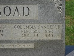
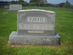
Columbia Martha “Lummie” Sandefur Goad
| Birth | : | 25 Feb 1860 Patrick County, Virginia, USA |
| Death | : | 19 Apr 1945 Carroll County, Virginia, USA |
| Burial | : | Schurz Paiute Indian Cemetery, Schurz, Mineral County, USA |
| Coordinate | : | 38.9740982, -118.8443985 |
frequently asked questions (FAQ):
-
Where is Columbia Martha “Lummie” Sandefur Goad's memorial?
Columbia Martha “Lummie” Sandefur Goad's memorial is located at: Schurz Paiute Indian Cemetery, Schurz, Mineral County, USA.
-
When did Columbia Martha “Lummie” Sandefur Goad death?
Columbia Martha “Lummie” Sandefur Goad death on 19 Apr 1945 in Carroll County, Virginia, USA
-
Where are the coordinates of the Columbia Martha “Lummie” Sandefur Goad's memorial?
Latitude: 38.9740982
Longitude: -118.8443985
Family Members:
Parent
Spouse
Siblings
Children
Flowers:
Nearby Cemetories:
1. Schurz Paiute Indian Cemetery
Schurz, Mineral County, USA
Coordinate: 38.9740982, -118.8443985
2. Valley View Cemetery
Yerington, Lyon County, USA
Coordinate: 38.9643593, -119.1384888
3. Yerington Paiute Memorial Cemetery
Yerington, Lyon County, USA
Coordinate: 38.9367900, -119.1924100
4. Elm Tree Cemetery
Yerington, Lyon County, USA
Coordinate: 38.8274994, -119.1682968
5. Virginia Mahon Gravesite
Walker Lake, Mineral County, USA
Coordinate: 38.6531300, -118.7615500
6. Rawhide Cemetery
Mineral County, USA
Coordinate: 39.0424995, -118.4019012
7. Pine Grove Cemetery
Pine Grove, Lyon County, USA
Coordinate: 38.6825000, -119.1255000
8. Wrightman Ranch Cemetery
Fallon, Churchill County, USA
Coordinate: 39.2026000, -118.4540000
9. Valley Grove Cemetery
Smith, Lyon County, USA
Coordinate: 38.8020510, -119.3383030
10. Saint Marys Episcopal Church Cemetery
Nixon, Washoe County, USA
Coordinate: 38.8329910, -119.3573040
11. Hillcrest Cemetery
Smith, Lyon County, USA
Coordinate: 38.7867012, -119.3343964
12. Turner Grave Site
Churchill County, USA
Coordinate: 39.2915479, -118.4477394
13. Saint Clair Cemetery
Fallon, Churchill County, USA
Coordinate: 39.4150009, -118.7782974
14. Allen Road Cemetery
Fallon, Churchill County, USA
Coordinate: 39.4275000, -118.8000000
15. Fort Churchill Cemetery
Lyon County, USA
Coordinate: 39.2956009, -119.2667007
16. Everett Family Cemetery
Wellington, Lyon County, USA
Coordinate: 38.7844880, -119.3903490
17. Hawthorne Cemetery
Hawthorne, Mineral County, USA
Coordinate: 38.5340004, -118.6253967
18. Chinese Cemetery
Hawthorne, Mineral County, USA
Coordinate: 38.5334300, -118.6144800
19. Poinsettia Burial Ground
Hawthorne, Mineral County, USA
Coordinate: 38.7787400, -118.2624100
20. Holy Trinity Episcopal Church Columbarium
Fallon, Churchill County, USA
Coordinate: 39.4701760, -118.7755950
21. Rosewood Drive Cemetery
Fallon, Churchill County, USA
Coordinate: 39.4731400, -118.8431100
22. Gardens Cemetery
Fallon, Churchill County, USA
Coordinate: 39.4751000, -118.7234000
23. Churchill County Cemetery
Fallon, Churchill County, USA
Coordinate: 39.4812900, -118.7518500
24. McMichael Family Cemetery
Douglas County, USA
Coordinate: 38.7380900, -119.4315700

