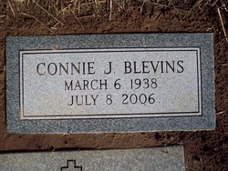
Connie Jean Reed Blevins
| Birth | : | 6 Mar 1938 Cabell County, West Virginia, USA |
| Death | : | 8 Jul 2006 Huntington, Cabell County, West Virginia, USA |
| Burial | : | Dawson Cemetery, Kidder County, USA |
| Coordinate | : | 46.8642006, -99.7200012 |
| Plot | : | Upper III Section |
| Inscription | : | CONNIE J. BLEVINS MARCH 6, 1938 JULY 8, 2006 |
| Description | : | CONNIE JEAN REED BLEVINS, 68, of Huntington, W.Va., passed away Saturday, July 8, 2006, in Hospice House of Huntington. Funeral services will be conducted 12:30 p.m. Tuesday, July 11, 2006, at Chapman's Mortuary, Huntington, with Dr. David B. Lemming officiating. Burial will be in Forest Memorial Park, Milton, W.Va. She was born March 6, 1938, in Cabell County, West Virginia, a daughter of the late Able and Norma Harris Reed. In addition to her parents, two husbands, one sister and five brothers also preceded her in death. She was a homemaker and a member of Lewis Memorial Baptist Church. Survivors... Read More |
frequently asked questions (FAQ):
-
Where is Connie Jean Reed Blevins's memorial?
Connie Jean Reed Blevins's memorial is located at: Dawson Cemetery, Kidder County, USA.
-
When did Connie Jean Reed Blevins death?
Connie Jean Reed Blevins death on 8 Jul 2006 in Huntington, Cabell County, West Virginia, USA
-
Where are the coordinates of the Connie Jean Reed Blevins's memorial?
Latitude: 46.8642006
Longitude: -99.7200012
Family Members:
Parent
Spouse
Siblings
Flowers:
Nearby Cemetories:
1. Dawson Cemetery
Kidder County, USA
Coordinate: 46.8642006, -99.7200012
2. Tappen Cemetery
Tappen, Kidder County, USA
Coordinate: 46.8783000, -99.6375000
3. Fisher Cemetery
Tappen, Kidder County, USA
Coordinate: 46.8941994, -99.6374969
4. Liberty Cemetery
Kidder County, USA
Coordinate: 46.7846985, -99.7110977
5. Koestler Cemetery
Tappen, Kidder County, USA
Coordinate: 46.7845600, -99.7112000
6. Allen Cemetery
Kidder County, USA
Coordinate: 46.9155998, -99.8647003
7. Woodlawn Cemetery
Steele, Kidder County, USA
Coordinate: 46.8806000, -99.9094009
8. Holy Cross Cemetery
Steele, Kidder County, USA
Coordinate: 46.8463400, -99.9115500
9. Buckeye Lutheran Cemetery
Tappen, Kidder County, USA
Coordinate: 46.9950600, -99.6710000
10. Liberty Methodist Episcopal Cemetery
Kidder County, USA
Coordinate: 46.7196999, -99.7652969
11. Zoar Evangelical Cemetery
Kidder County, USA
Coordinate: 46.7337000, -99.6184200
12. Big Mound Battlefield State Historic Site
Tappen, Kidder County, USA
Coordinate: 47.0224080, -99.6288710
13. Crystal Springs Cemetery
Crystal Springs, Kidder County, USA
Coordinate: 46.8709590, -99.4541220
14. Glueckstal Cemetery
Kidder County, USA
Coordinate: 46.6831017, -99.6810989
15. Weiser Cemetery
Kidder County, USA
Coordinate: 47.0430984, -99.5646973
16. Fairview Cemetery
Lake Williams, Kidder County, USA
Coordinate: 47.0816803, -99.6518784
17. Friedens Cemetery
Kidder County, USA
Coordinate: 46.6909600, -99.5125900
18. Evangelical Lutheran Split Cemetery
Kidder County, USA
Coordinate: 46.7040200, -99.4488000
19. Evangelical Lutheran Cemetery
Streeter, Stutsman County, USA
Coordinate: 46.7042590, -99.4484080
20. Saint Peters Cemetery
Stutsman County, USA
Coordinate: 46.7905998, -99.3694000
21. Bethel Cemetery
Kidder County, USA
Coordinate: 46.6907997, -99.9950027
22. Pursian Lake Cemetery
Kidder County, USA
Coordinate: 46.6906100, -99.9955800
23. Peace Lutheran Cemetery
Kidder County, USA
Coordinate: 46.6464500, -99.5126500
24. Kleve Cemetery
Robinson, Kidder County, USA
Coordinate: 47.1112800, -99.8404200


