
| Birth | : | 11 May 1942 |
| Death | : | 27 Jul 2012 |
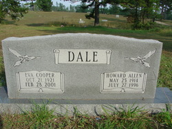
| Burial | : | Briar Oak Ridge Cemetery, Briar, Ripley County, USA |
| Coordinate | : | 36.6643800, -91.0557500 |
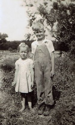
| Description | : | Connie Roy Dale, 70, of Doniphan, Missouri, died Friday, July 27, 2012, at his residence. Mr. Dale, son of Rector Allen and Emma May (Rackley) Dale, was born May 11, 1942, in Oregon County, Missouri. He was a life-long resident of Ripley County. Mr. Dale was a truck and bus driver and was a member of the Baptist Church. He enjoyed fishing with Charles, hunting, reading, working crossword puzzles, gardening, watching Gunsmoke and playing with his great-grandchildren. He also liked to swim with his friend, Rick, in the Blue Hole. On December 11, 1962, he was married to Sandra Silkwood... Read More |
frequently asked questions (FAQ):
-
Where is Connie Roy Dale's memorial?
Connie Roy Dale's memorial is located at: Briar Oak Ridge Cemetery, Briar, Ripley County, USA.
-
When did Connie Roy Dale death?
Connie Roy Dale death on 27 Jul 2012 in
-
Where are the coordinates of the Connie Roy Dale's memorial?
Latitude: 36.6643800
Longitude: -91.0557500
Family Members:
Parent
Spouse
Siblings
Children
Flowers:


Nearby Cemetories:
1. Briar Oak Ridge Cemetery
Briar, Ripley County, USA
Coordinate: 36.6643800, -91.0557500
2. Pine Cemetery
Ripley County, USA
Coordinate: 36.7161500, -91.0973000
3. Bardley Cemetery
Bardley, Ripley County, USA
Coordinate: 36.7016983, -91.1207962
4. Little Cemetery
Ripley County, USA
Coordinate: 36.6225014, -90.9860992
5. Chestnut Cemetery
Bennett, Ripley County, USA
Coordinate: 36.7132988, -90.9831009
6. Bennett Cemetery
Bennett, Ripley County, USA
Coordinate: 36.7318993, -90.9993973
7. Shirley Cemetery
Briar, Ripley County, USA
Coordinate: 36.6361008, -90.9580994
8. Gatewood Cemetery
Gatewood, Ripley County, USA
Coordinate: 36.5751600, -91.0900900
9. Kennon Cemetery
Ripley County, USA
Coordinate: 36.6082993, -90.9593964
10. Old Ponder Cemetery
Ripley County, USA
Coordinate: 36.5830994, -90.9871979
11. Pleasant Hill Cemetery
Calm, Oregon County, USA
Coordinate: 36.5950012, -91.1425018
12. Ponder Catholic Cemetery
Ponder, Ripley County, USA
Coordinate: 36.5814100, -90.9793800
13. Ponder Cemetery
Doniphan, Ripley County, USA
Coordinate: 36.5814018, -90.9792023
14. Hufstedler Cemetery
Ripley County, USA
Coordinate: 36.7543983, -90.9819031
15. Dobbs Lahue Cemetery
Riverton, Oregon County, USA
Coordinate: 36.6269300, -91.1823600
16. Wilson Cemetery
Doniphan, Ripley County, USA
Coordinate: 36.6391983, -90.9225006
17. Boze Mill Cemetery
Boze Mill, Oregon County, USA
Coordinate: 36.6631126, -91.1940231
18. Union Grove Cemetery
Ripley County, USA
Coordinate: 36.5597000, -90.9981003
19. Dobbs-LaHue Cemetery
Riverton, Oregon County, USA
Coordinate: 36.6233978, -91.1966476
20. Tucker Cemetery
Tucker (Gatewood), Ripley County, USA
Coordinate: 36.5426417, -91.0757139
21. Riverton Cemetery
Riverton, Oregon County, USA
Coordinate: 36.6476100, -91.2076900
22. Rosson Cemetery
Ripley County, USA
Coordinate: 36.6363983, -90.9060974
23. Liberty Cemetery
Calm, Oregon County, USA
Coordinate: 36.5586500, -91.1549600
24. Old Dalton Family Cemetery
Ponder, Ripley County, USA
Coordinate: 36.5568780, -90.9547810