
| Birth | : | 18 Feb 1942 Afton, Union County, Iowa, USA |
| Death | : | 17 Aug 2018 Excelsior Springs, Clay County, Missouri, USA |
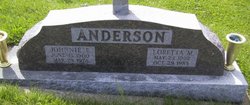
| Burial | : | Greenlawn Cemetery, Afton, Union County, USA |
| Coordinate | : | 41.0335999, -94.1856003 |
| Description | : | Constance Dady, 76, of Excelsior Springs, MO, formerly of Afton, passed away at home in her sleep in the early morning hours of August 17, 2018. She was surrounded by family and her precious poodles, Gembeau and Silver. Celebration of life funeral services will be 1:00 p.m. Saturday, August 25, 2018 at Powers Funeral Home in Afton. Pastor Jerry Richards will officiate the service. Burial will be at the Greenlawn Cemetery in Afton. Open visitation with family receiving friends will begin at noon, followed by the funeral service at 1 p.m. on Saturday. In lieu of flowers, please... Read More |
frequently asked questions (FAQ):
-
Where is Constance Amelia Anderson Dady's memorial?
Constance Amelia Anderson Dady's memorial is located at: Greenlawn Cemetery, Afton, Union County, USA.
-
When did Constance Amelia Anderson Dady death?
Constance Amelia Anderson Dady death on 17 Aug 2018 in Excelsior Springs, Clay County, Missouri, USA
-
Where are the coordinates of the Constance Amelia Anderson Dady's memorial?
Latitude: 41.0335999
Longitude: -94.1856003
Family Members:
Parent

Flowers:


Nearby Cemetories:
1. Greenlawn Cemetery
Afton, Union County, USA
Coordinate: 41.0335999, -94.1856003
2. Civil War Era Cemetery
Afton, Union County, USA
Coordinate: 41.0460854, -94.2025299
3. Saint Edwards Catholic Cemetery
Afton, Union County, USA
Coordinate: 41.0359993, -94.2129974
4. Norris Plot Cemetery
Afton, Union County, USA
Coordinate: 41.0079994, -94.1579971
5. Rollins Plot Cemetery
Afton, Union County, USA
Coordinate: 41.0040283, -94.2234802
6. County Home Cemetery
Creston, Union County, USA
Coordinate: 41.0449982, -94.2590027
7. Abel Cemetery
Arispe, Union County, USA
Coordinate: 40.9790001, -94.1429977
8. Mount Pisgah Cemetery
Thayer, Union County, USA
Coordinate: 41.0511017, -94.1007996
9. Browns Mountain Cemetery
Thayer, Union County, USA
Coordinate: 41.0499992, -94.0999985
10. Otterbein Cemetery
Thayer, Union County, USA
Coordinate: 40.9990005, -94.0879974
11. Beulah Cemetery
Thayer, Union County, USA
Coordinate: 41.0589981, -94.0759964
12. West Union Cemetery
Thayer, Union County, USA
Coordinate: 41.0191994, -94.0721970
13. Groesbeck Cemetery
Lorimor, Union County, USA
Coordinate: 41.1100006, -94.1230011
14. Cedar Grove Cemetery
Lorimor, Union County, USA
Coordinate: 41.1209984, -94.2200012
15. Bethel Cemetery
Thayer, Union County, USA
Coordinate: 41.0600014, -94.0693970
16. Dodge Center Cemetery
Afton, Union County, USA
Coordinate: 41.1279984, -94.1829987
17. Monette Cemetery
Lorimor, Union County, USA
Coordinate: 41.0800743, -94.0715866
18. Bragg Cemetery
Lorimor, Union County, USA
Coordinate: 41.1282997, -94.1433029
19. Evergreen Cemetery
Creston, Union County, USA
Coordinate: 41.1139984, -94.2839966
20. Thayer Catholic Cemetery
Thayer, Union County, USA
Coordinate: 41.0374985, -94.0357971
21. Claypool Cemetery
Thayer, Union County, USA
Coordinate: 41.0126114, -94.0303497
22. Old Jerusalem Cemetery
Creston, Union County, USA
Coordinate: 41.1159401, -94.3084335
23. Graceland Cemetery
Creston, Union County, USA
Coordinate: 41.0369987, -94.3519974
24. Lorimor Cemetery
Lorimor, Union County, USA
Coordinate: 41.1128006, -94.0516968