
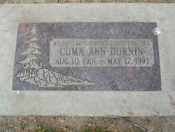
Cuma Ann Floyd Durnin
| Birth | : | 10 Aug 1901 Brownbranch, Taney County, Missouri, USA |
| Death | : | 13 May 1993 East Wenatchee, Douglas County, Washington, USA |
| Burial | : | Black Hills National Cemetery, Sturgis, Meade County, USA |
| Coordinate | : | 44.3689003, -103.4753036 |
| Description | : | Wenatchee World - Posted May 16, 1993 EAST WENATCHEE _ Cuma Ann Durnin, 91, of East Wenatchee, died Thursday, May 13, 1993, at her residence following an extended illness. She was born Aug. 10, 1901, to Amey and Emley (Clark) Floyd, at Brownbranch, Mo. She spent her early years in Missouri, then moved as a young woman to Washington. She worked as a waitress at Yakima. She moved to the Hawaiian Islands in 1934. She married Charles K. Durnin on Dec. 24, 1943, at Honolulu, where they lived until the end of the war. They returned to the mainland where they... Read More |
frequently asked questions (FAQ):
-
Where is Cuma Ann Floyd Durnin's memorial?
Cuma Ann Floyd Durnin's memorial is located at: Black Hills National Cemetery, Sturgis, Meade County, USA.
-
When did Cuma Ann Floyd Durnin death?
Cuma Ann Floyd Durnin death on 13 May 1993 in East Wenatchee, Douglas County, Washington, USA
-
Where are the coordinates of the Cuma Ann Floyd Durnin's memorial?
Latitude: 44.3689003
Longitude: -103.4753036
Family Members:
Parent
Spouse
Siblings

Children
Flowers:


Nearby Cemetories:
1. Black Hills National Cemetery
Sturgis, Meade County, USA
Coordinate: 44.3689003, -103.4753036
2. Curley Grimes Memorial Cemetery
Sturgis, Meade County, USA
Coordinate: 44.3764500, -103.4691300
3. Fort Meade National Cemetery
Sturgis, Meade County, USA
Coordinate: 44.4021988, -103.4757996
4. Bear Butte Cemetery
Sturgis, Meade County, USA
Coordinate: 44.4111595, -103.4947968
5. Saint Aloysius Cemetery
Sturgis, Meade County, USA
Coordinate: 44.4141340, -103.5193420
6. Pleasant Valley Cemetery
Tilford, Meade County, USA
Coordinate: 44.3192500, -103.3531160
7. Galena Cemetery
Galena, Lawrence County, USA
Coordinate: 44.3349220, -103.6438410
8. Crook City Cemetery
Crook City, Lawrence County, USA
Coordinate: 44.4432100, -103.6241500
9. Piedmont Cemetery
Piedmont, Meade County, USA
Coordinate: 44.2425780, -103.3871730
10. Oak Ridge Cemetery
Deadwood, Lawrence County, USA
Coordinate: 44.3891983, -103.6766968
11. Whitewood Cemetery
Whitewood, Lawrence County, USA
Coordinate: 44.4617820, -103.6330030
12. Roubaix Cemetery
Roubaix, Lawrence County, USA
Coordinate: 44.2789380, -103.6656600
13. Mount Moriah Cemetery
Deadwood, Lawrence County, USA
Coordinate: 44.3760986, -103.7253036
14. Saint Ambrose Cemetery
Deadwood, Lawrence County, USA
Coordinate: 44.3821983, -103.7266998
15. Nemo Cemetery
Nemo, Lawrence County, USA
Coordinate: 44.1872800, -103.5066410
16. Anderson Cemetery
Lawrence County, USA
Coordinate: 44.4747009, -103.6896973
17. South Lead Cemetery
Lead, Lawrence County, USA
Coordinate: 44.3478510, -103.7606260
18. Little Dane Cemetery
Saint Onge, Lawrence County, USA
Coordinate: 44.5252500, -103.6705540
19. Mountain Meadow Cemetery
Lawrence County, USA
Coordinate: 44.2038994, -103.6557999
20. West Lead Cemetery
Lead, Lawrence County, USA
Coordinate: 44.3484001, -103.7779999
21. Gate of Heaven Cemetery
Saint Onge, Lawrence County, USA
Coordinate: 44.5353000, -103.7237000
22. Terry Cemetery
Terry, Lawrence County, USA
Coordinate: 44.3344290, -103.8165110
23. Vale Cemetery
Vale, Butte County, USA
Coordinate: 44.6138992, -103.4052963
24. Holy Cross Cemetery
Englewood, Lawrence County, USA
Coordinate: 44.2818985, -103.8047028