
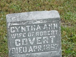
Cynthia Ann Yoder Covert
| Birth | : | 1825 Indiana, USA |
| Death | : | 1 Apr 1867 Davis County, Iowa, USA |
| Burial | : | Saint Andrews Churchyard, Hartburn, Northumberland Unitary Authority, England |
| Coordinate | : | 55.1683350, -1.8596667 |
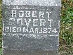
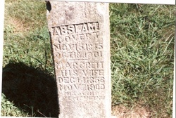
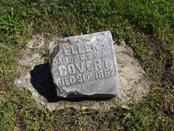
| Description | : | Cynthia Ann Yoder married Robert Covert on 5 January 1843 in Bartholomew co., Indiana. They were the parents of Jacob, Anna Belle, Margaret Jane, Absolom, Alexander, Martha and Ellen Covert. Daughter, Anna Belle - Memorial# 27027591 |
frequently asked questions (FAQ):
-
Where is Cynthia Ann Yoder Covert's memorial?
Cynthia Ann Yoder Covert's memorial is located at: Saint Andrews Churchyard, Hartburn, Northumberland Unitary Authority, England.
-
When did Cynthia Ann Yoder Covert death?
Cynthia Ann Yoder Covert death on 1 Apr 1867 in Davis County, Iowa, USA
-
Where are the coordinates of the Cynthia Ann Yoder Covert's memorial?
Latitude: 55.1683350
Longitude: -1.8596667
Family Members:
Parent
Spouse
Siblings

Children
Flowers:


Nearby Cemetories:
1. Saint Andrews Churchyard
Hartburn, Northumberland Unitary Authority, England
Coordinate: 55.1683350, -1.8596667
2. St Andrew Churchyard
Bolam, Northumberland Unitary Authority, England
Coordinate: 55.1376680, -1.8565600
3. St. John Churchyard
Meldon, Northumberland Unitary Authority, England
Coordinate: 55.1489650, -1.8144770
4. Tomb Garden, Harnham Hall
Belsay, Northumberland Unitary Authority, England
Coordinate: 55.1183970, -1.8862270
5. Holy Trinity Churchyard
Cambo, Northumberland Unitary Authority, England
Coordinate: 55.1659450, -1.9598470
6. Cambo Burial Ground
Cambo, Northumberland Unitary Authority, England
Coordinate: 55.1678800, -1.9665200
7. Saint Mary Magdalene Churchyard
Mitford, Northumberland Unitary Authority, England
Coordinate: 55.1645410, -1.7363020
8. Belsay Woodland Burials
Belsay, Northumberland Unitary Authority, England
Coordinate: 55.0985470, -1.8388940
9. St. Wilfrid Churchyard
Kirkharle, Northumberland Unitary Authority, England
Coordinate: 55.1381750, -1.9832180
10. Fairmoor Cemetery
Morpeth, Northumberland Unitary Authority, England
Coordinate: 55.1861980, -1.7163260
11. St Bartholomew Churchyard
Kirkwhelpington, Northumberland Unitary Authority, England
Coordinate: 55.1539930, -2.0070970
12. Newminster Abbey
Morpeth, Northumberland Unitary Authority, England
Coordinate: 55.1664000, -1.7044070
13. Saint Helen’s Churchyard
Longhorsley, Northumberland Unitary Authority, England
Coordinate: 55.2432500, -1.7588200
14. St. Mary the Virgin Churchyard
Morpeth, Northumberland Unitary Authority, England
Coordinate: 55.1597110, -1.6921530
15. St. Mary the Virgin Church
Morpeth, Northumberland Unitary Authority, England
Coordinate: 55.1598990, -1.6917760
16. St Cuthbert Churchyard
Hebron, Northumberland Unitary Authority, England
Coordinate: 55.2023450, -1.6963700
17. Holy Saviour Churchyard
Milbourne, Northumberland Unitary Authority, England
Coordinate: 55.0699360, -1.8177890
18. St Bartholomew Churchyard
Kirkheaton, Northumberland Unitary Authority, England
Coordinate: 55.0902060, -1.9740250
19. Brinkburn Priory
Brinkburn, Northumberland Unitary Authority, England
Coordinate: 55.2788120, -1.8191170
20. Brinkburn Priory and Manor House
Longframlington, Northumberland Unitary Authority, England
Coordinate: 55.2789620, -1.8194090
21. Saint John's Churchyard
Longhirst, Northumberland Unitary Authority, England
Coordinate: 55.1936200, -1.6474840
22. Holy Trinity Churchyard
Dalton, Northumberland Unitary Authority, England
Coordinate: 55.0423380, -1.8266440
23. St Andrew's Churchyard
Bothal, Northumberland Unitary Authority, England
Coordinate: 55.1731340, -1.6205890
24. Longframlington Church Cemetery Extension
Longframlington, Northumberland Unitary Authority, England
Coordinate: 55.3014700, -1.7950600