

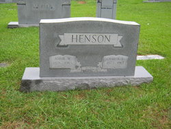
Cynthia Annie Webster Henson
| Birth | : | 20 Mar 1876 North Carolina, USA |
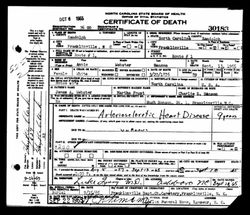
| Death | : | 13 Sep 1965 Franklinville, Randolph County, North Carolina, USA |
| Burial | : | First Baptist Church Cemetery, Franklinville, Randolph County, USA |
| Coordinate | : | 35.7482230, -79.6908630 |
| Description | : | Father: James A. Webster Mother: Martha Foust Marriage 1 Charlie Edgar Henson b: 2 AUG1873 in Randolph County, North Carolina *Married: 12 Feb 1899 —Randolph County, North Carolina Children: Charles Thomas Henson b: 12 Mar 1900 Eva Rachel Henson b: 1902 James Oscar Henson b: 14 Apr 1904 Gurney Lee Henson b: 6 Sept 1906 Ruby Iola Henson b: 12 Jan 1909 Carl Webster Henson b: 26 Sept 1910 Paul Hilliard Henson b: 29 Sep 1912 George Kermit Henson b: 01 Mar 1915 Hugh Glenn Henson b: 17... Read More |
frequently asked questions (FAQ):
-
Where is Cynthia Annie Webster Henson's memorial?
Cynthia Annie Webster Henson's memorial is located at: First Baptist Church Cemetery, Franklinville, Randolph County, USA.
-
When did Cynthia Annie Webster Henson death?
Cynthia Annie Webster Henson death on 13 Sep 1965 in Franklinville, Randolph County, North Carolina, USA
-
Where are the coordinates of the Cynthia Annie Webster Henson's memorial?
Latitude: 35.7482230
Longitude: -79.6908630
Family Members:
Parent

Spouse
Siblings
Children
Flowers:


Nearby Cemetories:
1. First Baptist Church Cemetery
Franklinville, Randolph County, USA
Coordinate: 35.7482230, -79.6908630
2. Franklinville United Methodist Church Cemetery
Franklinville, Randolph County, USA
Coordinate: 35.7462900, -79.7037500
3. Old Salem Cemetery
Franklinville, Randolph County, USA
Coordinate: 35.7414017, -79.6742020
4. Billy Trogdon Cemetery
Asheboro, Randolph County, USA
Coordinate: 35.7392800, -79.7219100
5. Clear View Baptist Church Cemetery
Franklinville, Randolph County, USA
Coordinate: 35.7530800, -79.7234300
6. Ramseur Wesleyan Church Cemetery
Ramseur, Randolph County, USA
Coordinate: 35.7305670, -79.6593030
7. Cedar Falls United Methodist Church Cemetery
Asheboro, Randolph County, USA
Coordinate: 35.7472920, -79.7338990
8. Cedar Falls Baptist Church Cemetery
Cedar Falls, Randolph County, USA
Coordinate: 35.7480800, -79.7357800
9. Providence Baptist Church Cemetery
Asheboro, Randolph County, USA
Coordinate: 35.7231400, -79.7237930
10. Pleasant Cross Christian Church Cemetery
Asheboro, Randolph County, USA
Coordinate: 35.7254000, -79.7268740
11. Sunset Knoll Cemetery
Ramseur, Randolph County, USA
Coordinate: 35.7313995, -79.6500015
12. Friendship AME Church Cemetery
Ramseur, Randolph County, USA
Coordinate: 35.7463280, -79.6437970
13. Patterson Grove Christian Church Cemetery
Ramseur, Randolph County, USA
Coordinate: 35.7743940, -79.6536550
14. Shady Grove Community Cemetery
Asheboro, Randolph County, USA
Coordinate: 35.7192180, -79.7287920
15. Harmony Baptist Church Cemetery
Ramseur, Randolph County, USA
Coordinate: 35.7241680, -79.6418910
16. Pleasant Ridge Christian Church Cemetery
Ramseur, Randolph County, USA
Coordinate: 35.7046860, -79.6670060
17. Whites Memorial Baptist Church Cemetery
Franklinville, Randolph County, USA
Coordinate: 35.7939680, -79.7149760
18. Parks-Stout Cemetery
Randolph County, USA
Coordinate: 35.7205460, -79.6373740
19. Whites Chapel United Methodist Church Cemetery
Liberty, Randolph County, USA
Coordinate: 35.7850520, -79.6422990
20. Odell Trogdon Cemetery
Grays Chapel, Randolph County, USA
Coordinate: 35.7947200, -79.7300200
21. Bible Truth Church Cemetery
Ramseur, Randolph County, USA
Coordinate: 35.7485370, -79.6204580
22. Cool Springs Baptist Church Cemetery
Franklinville, Randolph County, USA
Coordinate: 35.8072420, -79.6805660
23. York Family Cemetery
Ramseur, Randolph County, USA
Coordinate: 35.7603000, -79.6108000
24. Mill Creek Friends Cemetery
Asheboro, Randolph County, USA
Coordinate: 35.6922270, -79.6463380