

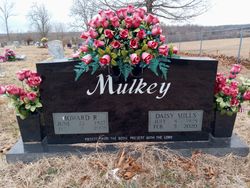
Daisy Marie Mills Mulkey
| Birth | : | 8 Jul 1928 Couch, Oregon County, Missouri, USA |
| Death | : | 5 Feb 2020 West Plains, Howell County, Missouri, USA |
| Burial | : | New Salem Cemetery, Couch, Oregon County, USA |
| Coordinate | : | 36.6042252, -91.3712463 |
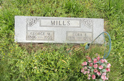
| Description | : | Daisy Marie Mills Mulkey, 91, was born the daughter of George Mills and Cora Norman Mills on July 8, 1928 in Couch, Missouri and departed this life February 5, 2020 at her home in West Plains, Missouri. Daisy was united in marriage to Howard Mulkey on September 8, 1946 in Mammoth Spring, Arkansas and they shared sixty-one years together until his death. Daisy was survived by and blessed with 5 children, Ray (Marcia) Mulkey, Springfield, Missouri; Steve (Daryl) Mulkey, Nampa, Idaho; Mark (Barb) Mulkey, West Plains, Missouri; Frances (Tim) Gingles, Peculiar, Missouri; Carol (Mike) Ford; Peace Valley, Missouri;... Read More |
frequently asked questions (FAQ):
-
Where is Daisy Marie Mills Mulkey's memorial?
Daisy Marie Mills Mulkey's memorial is located at: New Salem Cemetery, Couch, Oregon County, USA.
-
When did Daisy Marie Mills Mulkey death?
Daisy Marie Mills Mulkey death on 5 Feb 2020 in West Plains, Howell County, Missouri, USA
-
Where are the coordinates of the Daisy Marie Mills Mulkey's memorial?
Latitude: 36.6042252
Longitude: -91.3712463
Family Members:
Parent

Spouse

Siblings

Flowers:


Nearby Cemetories:
1. New Salem Cemetery
Couch, Oregon County, USA
Coordinate: 36.6042252, -91.3712463
2. Olon Tucker Farm Cemetery #2
Couch, Oregon County, USA
Coordinate: 36.5867000, -91.3705400
3. Baker Cemetery
Couch, Oregon County, USA
Coordinate: 36.6248283, -91.3932877
4. Garfield Cemetery
Garfield, Oregon County, USA
Coordinate: 36.5844400, -91.3253400
5. Cave Springs Cemetery #2
Alton, Oregon County, USA
Coordinate: 36.6488900, -91.3652900
6. Cave Springs Cemetery
Alton, Oregon County, USA
Coordinate: 36.6492004, -91.3655014
7. Crabb Cemetery
Couch, Oregon County, USA
Coordinate: 36.5988541, -91.4339752
8. Arytown Cemetery
Arytown, Oregon County, USA
Coordinate: 36.5539513, -91.3795776
9. Bonds Cemetery
Couch, Oregon County, USA
Coordinate: 36.5989914, -91.4346619
10. Russell Cemetery
Couch, Oregon County, USA
Coordinate: 36.5506477, -91.3991928
11. Adolph Ostrom Farm Cemetery
Thayer, Oregon County, USA
Coordinate: 36.5788160, -91.4426640
12. Guiteau-Risner Cemetery
Guiteau, Oregon County, USA
Coordinate: 36.5588074, -91.3156128
13. Norman Cemetery
Alton, Oregon County, USA
Coordinate: 36.6143990, -91.4499969
14. John Brown Cemetery
Jobe, Oregon County, USA
Coordinate: 36.5812111, -91.2953568
15. Copenhagen Cemetery
Couch, Oregon County, USA
Coordinate: 36.6347421, -91.4460619
16. Copenhagen Family Cemetery
Alton, Oregon County, USA
Coordinate: 36.6369684, -91.4464551
17. Crass Homestead
Myrtle, Oregon County, USA
Coordinate: 36.5359695, -91.3084671
18. Old Culp Place
Alton, Oregon County, USA
Coordinate: 36.6892400, -91.3760600
19. Lance Cemetery
Many Springs, Oregon County, USA
Coordinate: 36.6310997, -91.2699966
20. Midway Cemetery
Couch, Oregon County, USA
Coordinate: 36.6031690, -91.4788520
21. Cotton Creek Cemetery
Jobe, Oregon County, USA
Coordinate: 36.5844002, -91.2652969
22. Dills Cemetery
Alton, Oregon County, USA
Coordinate: 36.6596985, -91.4586029
23. Alton City Cemetery
Alton, Oregon County, USA
Coordinate: 36.6918983, -91.3982010
24. Many Springs Cemetery
Many Springs, Oregon County, USA
Coordinate: 36.6521200, -91.2695100