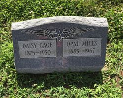
| Birth | : | 5 Jul 1875 Indiana, USA |
| Death | : | 21 Oct 1950 Cincinnati, Hamilton County, Ohio, USA |
| Burial | : | Maple Grove Cemetery, Brookville, Franklin County, USA |
| Coordinate | : | 39.4216995, -85.0216980 |
| Description | : | Daisy May Gage was the daughter of James W Gage & Mary Rosella Hutson, who are buried nearby. Daisy did not marry and had no issue. |
frequently asked questions (FAQ):
-
Where is Daisy May Gage's memorial?
Daisy May Gage's memorial is located at: Maple Grove Cemetery, Brookville, Franklin County, USA.
-
When did Daisy May Gage death?
Daisy May Gage death on 21 Oct 1950 in Cincinnati, Hamilton County, Ohio, USA
-
Where are the coordinates of the Daisy May Gage's memorial?
Latitude: 39.4216995
Longitude: -85.0216980
Family Members:
Parent
Siblings
Flowers:
Nearby Cemetories:
1. Maple Grove Cemetery
Brookville, Franklin County, USA
Coordinate: 39.4216995, -85.0216980
2. Berg-Harding Cemetery
Highland Center, Franklin County, USA
Coordinate: 39.4241667, -85.0113889
3. Old Brookville Cemetery
Brookville, Franklin County, USA
Coordinate: 39.4248505, -85.0097122
4. Vincent Cemetery
Franklin County, USA
Coordinate: 39.4281000, -85.0328000
5. Saint Michael Cemetery
Brookville, Franklin County, USA
Coordinate: 39.4308070, -85.0095360
6. Stringer Cemetery
Brookville, Franklin County, USA
Coordinate: 39.4057270, -85.0126160
7. Infirmary Cemetery
Brookville, Franklin County, USA
Coordinate: 39.4056000, -85.0125000
8. Martin Cemetery
Brookville, Franklin County, USA
Coordinate: 39.4189000, -85.0478000
9. Warne Cemetery
Brookville, Franklin County, USA
Coordinate: 39.4336000, -85.0472000
10. Stoops Cemetery
Brookville, Franklin County, USA
Coordinate: 39.4249100, -85.0518900
11. Bradburn Family Cemetery
Brookville, Franklin County, USA
Coordinate: 39.4138640, -84.9825850
12. Brookville Township Cemetery
Brookville, Franklin County, USA
Coordinate: 39.4347000, -84.9828000
13. Woodworth Cemetery
Brookville, Franklin County, USA
Coordinate: 39.4078000, -84.9811000
14. Elder Cemetery
Brookville, Franklin County, USA
Coordinate: 39.3986250, -84.9848120
15. Saint Philomena Cemetery
Brookville, Franklin County, USA
Coordinate: 39.3914250, -85.0485390
16. Meyncke Cemetery
Brookville, Franklin County, USA
Coordinate: 39.3881660, -85.0016050
17. Wilson Cemetery
Yellow Bank, Franklin County, USA
Coordinate: 39.4303000, -85.0683000
18. Calpha Cemetery
Brookville, Franklin County, USA
Coordinate: 39.4260990, -85.0706760
19. Little Cedar Public Cemetery
Mound Haven, Franklin County, USA
Coordinate: 39.3911066, -84.9868303
20. West Family Cemetery
Brookville, Franklin County, USA
Coordinate: 39.4019300, -84.9700200
21. Utsler Cemetery
Brookville, Franklin County, USA
Coordinate: 39.3806000, -84.9961000
22. Little Cedar Grove Baptist Meeting House Cemetery
Franklin County, USA
Coordinate: 39.3872414, -84.9817886
23. Halstead Cemetery
Brookville, Franklin County, USA
Coordinate: 39.4357010, -85.0788050
24. Collett Cemetery
Yellow Bank, Franklin County, USA
Coordinate: 39.4417940, -85.0763440


