
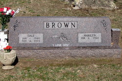
Dale “Brownie” Brown
| Birth | : | 1 Jan 1940 Neodesha, Wilson County, Kansas, USA |
| Death | : | 14 Nov 2004 Joplin, Jasper County, Missouri, USA |
| Burial | : | Moshassuck Cemetery, Central Falls, Providence County, USA |
| Coordinate | : | 41.8907089, -71.4024200 |
| Description | : | ~*~ DALE "BROWNIE" BROWN ~*~ (January 1, 1940 ~ November 14, 2004) Dale "Brownie" Brown, 64, of Pittsburg, Kansas, passed away at St. John's Regional Medical Center at Joplin, Mo. The son of Lonnie and Georgia Smith Brown. He was the owner of Brownies Towing and Auto Service on Langdon Lane south of Pittsburg. He married Marilyn Long on June 18, 1960 in Pittsburg< Ks. Children: Steve Brown and Julie Redd, both of Pittsburg, Ks. Ronnie Brown (deceased) Siblings: Norma Booe, Bill Brown, Larry Brown, and Don Brown, all of Pittsburg, Ks. George Brown of Lafayette, Colo. Ray Brown of Frontenac, Ks. He was preceded in death by Bud Brown, Mardel Denning, Marjorie... Read More |
frequently asked questions (FAQ):
-
Where is Dale “Brownie” Brown's memorial?
Dale “Brownie” Brown's memorial is located at: Moshassuck Cemetery, Central Falls, Providence County, USA.
-
When did Dale “Brownie” Brown death?
Dale “Brownie” Brown death on 14 Nov 2004 in Joplin, Jasper County, Missouri, USA
-
Where are the coordinates of the Dale “Brownie” Brown's memorial?
Latitude: 41.8907089
Longitude: -71.4024200
Family Members:
Parent

Siblings
Children
Flowers:


Nearby Cemetories:
1. Moshassuck Cemetery
Central Falls, Providence County, USA
Coordinate: 41.8907089, -71.4024200
2. Whipple-Northup Lot
Lincoln, Providence County, USA
Coordinate: 41.8995370, -71.4168610
3. Pierce Park and Riverwalk
Central Falls, Providence County, USA
Coordinate: 41.8938300, -71.3833000
4. Friends Burial Ground
Lincoln, Providence County, USA
Coordinate: 41.9006000, -71.4180000
5. Arnold Lot
Lincoln, Providence County, USA
Coordinate: 41.9009000, -71.4182000
6. Christ Church Cemetery
Lincoln, Providence County, USA
Coordinate: 41.9070816, -71.4021378
7. Jencks-Phetteplace-Whipple Lot
Lincoln, Providence County, USA
Coordinate: 41.9017330, -71.4187510
8. Rhode Island Historical Cemetery Lincoln #81
Lincoln, Providence County, USA
Coordinate: 41.9015560, -71.4191330
9. Mineral Spring Cemetery
Pawtucket, Providence County, USA
Coordinate: 41.8756450, -71.3919830
10. Saint Patricks Church Cemetery
Cumberland, Providence County, USA
Coordinate: 41.9070778, -71.3930817
11. Governor Joseph Jencks Lot
Pawtucket, Providence County, USA
Coordinate: 41.8790310, -71.3831690
12. Arnold Lot
Lincoln, Providence County, USA
Coordinate: 41.8817400, -71.4242600
13. Saint Johns Ukrainian Cemetery
Cumberland, Providence County, USA
Coordinate: 41.9076805, -71.3888626
14. Saint Patricks Cemetery
Cumberland, Providence County, USA
Coordinate: 41.9083290, -71.3900375
15. Austin-Thayer-Gorton Lot
Lincoln, Providence County, USA
Coordinate: 41.9092520, -71.4146090
16. Old Saint Marys Cemetery
Pawtucket, Providence County, USA
Coordinate: 41.8717117, -71.3885193
17. Consolation Church Grounds
Pawtucket, Providence County, USA
Coordinate: 41.8902140, -71.3727310
18. William Blackstone Memorial Park
Cumberland, Providence County, USA
Coordinate: 41.9148216, -71.3995132
19. Emerson Cemetery
Cumberland, Providence County, USA
Coordinate: 41.9148360, -71.3995040
20. Oak Grove Cemetery
Pawtucket, Providence County, USA
Coordinate: 41.8844910, -71.3709030
21. Cumberland Cemetery
Cumberland, Providence County, USA
Coordinate: 41.9133072, -71.3879623
22. Old Indian Cemetery
Cumberland, Providence County, USA
Coordinate: 41.9135132, -71.3865662
23. Olney Burial Ground
Lincoln, Providence County, USA
Coordinate: 41.8910000, -71.4381000
24. Rhode Island Historical Cemetery Lincoln #61
Lincoln, Providence County, USA
Coordinate: 41.8814780, -71.4372690