
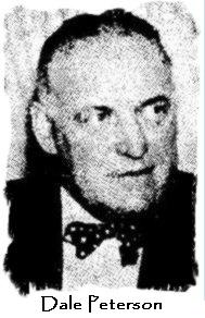
Dale E Peterson
| Birth | : | 1900 |
| Death | : | 31 May 1950 Dickinson County, Iowa, USA |
| Burial | : | Osage Cemetery, Osage, Mitchell County, USA |
| Coordinate | : | 43.2916700, -92.8201700 |
| Description | : | Rites Set for Dale Peterson Osage, Iowa — Funeral services for Dale Peterson, 49, who drowned in Lake Okoboji Tuesday evening, will be held Friday at the Methodist church, the Rev. C. D. James officiating. Burial will be in the Osage cemetery. Masonic rites will be held at the cemetery. Survivors include his parents, Mr. and Mrs. B. E. Peterson of Osage, his wife, Garnet Welch Peterson, daughter Janet and son James, both college students. The accident occurred when Peterson attempted to step from a larger motorboat to a smaller one containing the son of Herbert Langer of Des Moines.... Read More |
frequently asked questions (FAQ):
-
Where is Dale E Peterson's memorial?
Dale E Peterson's memorial is located at: Osage Cemetery, Osage, Mitchell County, USA.
-
When did Dale E Peterson death?
Dale E Peterson death on 31 May 1950 in Dickinson County, Iowa, USA
-
Where are the coordinates of the Dale E Peterson's memorial?
Latitude: 43.2916700
Longitude: -92.8201700
Family Members:
Parent

Spouse
Children
Flowers:


Nearby Cemetories:
1. Osage Cemetery
Osage, Mitchell County, USA
Coordinate: 43.2916700, -92.8201700
2. Sacred Heart Cemetery
Osage, Mitchell County, USA
Coordinate: 43.2742004, -92.7917023
3. South Osage Mennonite Church Cemetery
Osage, Mitchell County, USA
Coordinate: 43.2544556, -92.7915573
4. Tucker Cemetery
Osage, Mitchell County, USA
Coordinate: 43.2494011, -92.8319016
5. Oak Grove Cemetery
Mitchell, Mitchell County, USA
Coordinate: 43.3156013, -92.8707962
6. Calvary Cemetery
Osage, Mitchell County, USA
Coordinate: 43.2238998, -92.8300018
7. Orchard Cemetery
Orchard, Mitchell County, USA
Coordinate: 43.2249985, -92.7838898
8. Dudley Cemetery
Dudley (historical), Mitchell County, USA
Coordinate: 43.2252998, -92.8743973
9. Riverview Cemetery
Saint Ansgar, Mitchell County, USA
Coordinate: 43.3430328, -92.9220200
10. Rock Creek Cemetery
Meroa, Mitchell County, USA
Coordinate: 43.2352791, -92.9225006
11. Eden Presbyterian Cemetery
Meroa, Mitchell County, USA
Coordinate: 43.2131004, -92.9103012
12. West End Cemetery
Meroa, Mitchell County, USA
Coordinate: 43.2216682, -92.9250031
13. Saint Ansgar Cemetery
Saint Ansgar, Mitchell County, USA
Coordinate: 43.3777809, -92.9094391
14. Immanuel Lutheran Cemetery
Saint Ansgar, Mitchell County, USA
Coordinate: 43.3717003, -92.9257965
15. First Lutheran Cemetery
Saint Ansgar, Mitchell County, USA
Coordinate: 43.3841705, -92.9194412
16. Liberty Cemetery
Little Cedar, Mitchell County, USA
Coordinate: 43.3856010, -92.7230988
17. Beaver Creek Cemetery
Brownville, Mitchell County, USA
Coordinate: 43.3397217, -92.6727829
18. Blakestad Cemetery
Saint Ansgar, Mitchell County, USA
Coordinate: 43.3711014, -92.9400024
19. Saint Johns Lutheran Cemetery
Rock Creek, Mitchell County, USA
Coordinate: 43.3295560, -92.9849770
20. Saint Peters Cemetery
New Haven, Mitchell County, USA
Coordinate: 43.2858315, -92.6427765
21. Saint Johns Lutheran Old Cemetery
Rock Creek, Mitchell County, USA
Coordinate: 43.3313904, -92.9897232
22. Stillwater Cemetery
Orchard, Mitchell County, USA
Coordinate: 43.2130585, -92.6780624
23. McKinley Cemetery
Saint Ansgar, Mitchell County, USA
Coordinate: 43.3906400, -92.9368300
24. Howardville Cemetery
Floyd, Floyd County, USA
Coordinate: 43.1866989, -92.7016983