
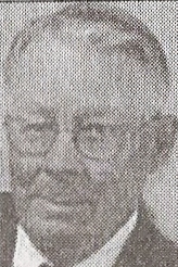

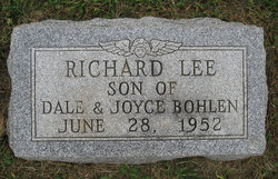
Dale Herman Bohlen
| Birth | : | 20 Sep 1931 Glenvil, Clay County, Nebraska, USA |
| Death | : | 4 May 2012 Hastings, Adams County, Nebraska, USA |
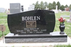
| Burial | : | Glenvil Cemetery, Glenvil, Clay County, USA |
| Coordinate | : | 40.5088400, -98.2604700 |
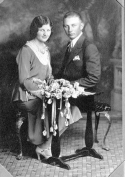
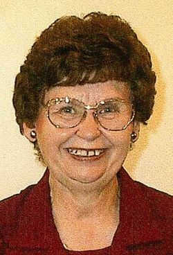
| Description | : | Dale H. Bohlen, 80, passed away Friday, May 4, 2012 at Mary Lanning Memorial HealthCare, Hastings, Nebraska. Dale was born September 20, 1931 in Glenvil, Nebraska to Herman & Sophia Frieda (Tjarks) Bohlen. Dale graduated from Glenvil High School in 1949. Dale married Joyce (Sherman) on November 4, 1951 at Immanuel Lutheran Church, Glenvil, Nebraska. He served with the U.S. Army from November 4, 1952 until September 30, 1954, during the Korean War. Dale lived and farmed in the Glenvil area for most of his life. He was a member of Immanuel Lutheran Church where he served on the Church... Read More |
frequently asked questions (FAQ):
-
Where is Dale Herman Bohlen's memorial?
Dale Herman Bohlen's memorial is located at: Glenvil Cemetery, Glenvil, Clay County, USA.
-
When did Dale Herman Bohlen death?
Dale Herman Bohlen death on 4 May 2012 in Hastings, Adams County, Nebraska, USA
-
Where are the coordinates of the Dale Herman Bohlen's memorial?
Latitude: 40.5088400
Longitude: -98.2604700
Family Members:
Parent

Spouse
Children
Flowers:


Nearby Cemetories:
1. Glenvil Cemetery
Glenvil, Clay County, USA
Coordinate: 40.5088400, -98.2604700
2. Saint Pauls Lutheran Cemetery
Adams County, USA
Coordinate: 40.5104530, -98.2872960
3. Glenville Union Cemetery
Glenvil, Clay County, USA
Coordinate: 40.5308980, -98.2052220
4. True Dutch Reformed Cemetery
Pauline, Adams County, USA
Coordinate: 40.4801300, -98.3160600
5. Scandinavian Lutheran Cemetery
Pauline, Adams County, USA
Coordinate: 40.4800700, -98.3162900
6. Fleming Farm Pet Cemetery
Hastings, Adams County, USA
Coordinate: 40.5547500, -98.3156100
7. Hanover Presbyterian Church Cemetery
Adams County, USA
Coordinate: 40.4802900, -98.3353850
8. South Inland Cemetery
Clay County, USA
Coordinate: 40.5682900, -98.2217500
9. Anandale Cemetery
Glenvil, Clay County, USA
Coordinate: 40.4661900, -98.1935300
10. Zion Cemetery
Clay County, USA
Coordinate: 40.5382996, -98.1643982
11. Old Inland Cemetery
Hastings, Adams County, USA
Coordinate: 40.5872300, -98.2974500
12. Inland Cemetery
Clay County, USA
Coordinate: 40.5964012, -98.2581024
13. Spring Ranch Cemetery
Clay County, USA
Coordinate: 40.4065100, -98.2484100
14. Kingston Cemetery
Adams County, USA
Coordinate: 40.4383250, -98.3695220
15. Mount Sinai Cemetery
Hastings, Adams County, USA
Coordinate: 40.5978012, -98.3647003
16. Parkview Cemetery
Hastings, Adams County, USA
Coordinate: 40.5985985, -98.3677979
17. Blue Valley Cemetery
Ayr, Adams County, USA
Coordinate: 40.4488983, -98.4011002
18. Saint Marks Episcopal Chapel Columbarium
Hastings, Adams County, USA
Coordinate: 40.5877800, -98.3922100
19. First Presbyterian Columbarium
Hastings, Adams County, USA
Coordinate: 40.5895900, -98.3913100
20. Crosier Monastery Cemetery
Hastings, Adams County, USA
Coordinate: 40.6014740, -98.3787920
21. Highland Cemetery
Hastings, Adams County, USA
Coordinate: 40.5983009, -98.3906021
22. Grace Methodist Church Memorial Columbarium
Hastings, Adams County, USA
Coordinate: 40.5937480, -98.4082340
23. Immanuel Lutheran Church Cemetery
Ayr, Adams County, USA
Coordinate: 40.5247870, -98.4583300
24. Saint Martin-Loucky Cemetery
Deweese, Clay County, USA
Coordinate: 40.3652496, -98.1948624