
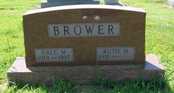
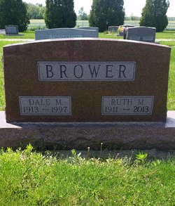
Dale M Brower
| Birth | : | 12 May 1913 |
| Death | : | 14 Apr 1997 |
| Burial | : | South Union Cemetery, Kokomo, Howard County, USA |
| Coordinate | : | 40.4745670, -86.3290160 |
| Description | : | Dale M. Brower, 83, rural Kokomo, died at 4 p.m. Monday, April 14, 1997, in St. Vincent Hospital, Indianapolis. Born May 12, 1913, in Howard County, he was the son of Leonidas and Mary Mason Brower. He was married June 5, 1932, in Howard County to Ruth Gillam, who survives. He owned and operated Shady Maples Mink Farm in Howard County, and was retired as a farmer and as director of Indiana State Agency for Surplus Property. He had 50-year memberships in New London Masonic Lodge, Order of the Eastern Star, Walton, and Scottish Rite and Murat Shrine, both of... Read More |
frequently asked questions (FAQ):
-
Where is Dale M Brower's memorial?
Dale M Brower's memorial is located at: South Union Cemetery, Kokomo, Howard County, USA.
-
When did Dale M Brower death?
Dale M Brower death on 14 Apr 1997 in
-
Where are the coordinates of the Dale M Brower's memorial?
Latitude: 40.4745670
Longitude: -86.3290160
Family Members:
Parent

Spouse
Siblings
Children

Flowers:


Nearby Cemetories:
1. South Union Cemetery
Kokomo, Howard County, USA
Coordinate: 40.4745670, -86.3290160
2. Miller Cemetery
Howard County, USA
Coordinate: 40.4643936, -86.3377228
3. Pleasant Hill Cemetery
Howard County, USA
Coordinate: 40.4531110, -86.3245450
4. Pete's Run Cemetery
Ervin Township, Howard County, USA
Coordinate: 40.4907960, -86.3565140
5. Price Cemetery
Ervin Township, Howard County, USA
Coordinate: 40.4748360, -86.2642600
6. Barnett Cemetery
Kokomo, Howard County, USA
Coordinate: 40.4757830, -86.2618590
7. Friends Cemetery
New London, Howard County, USA
Coordinate: 40.4446570, -86.2738480
8. Burlington Cemetery
Burlington, Carroll County, USA
Coordinate: 40.4813995, -86.3974991
9. Smith Cemetery
Forest, Clinton County, USA
Coordinate: 40.4203610, -86.3188500
10. Mound Cemetery
Poplar Grove, Howard County, USA
Coordinate: 40.5264015, -86.3535995
11. Old Prophet Cemetery
Clinton County, USA
Coordinate: 40.4225006, -86.3694000
12. Bassett Cemetery
Poplar Grove, Howard County, USA
Coordinate: 40.5374200, -86.3065300
13. Stringer Cemetery
Forest, Clinton County, USA
Coordinate: 40.4103012, -86.3475037
14. Russiaville Cemetery
Russiaville, Howard County, USA
Coordinate: 40.4196880, -86.2762570
15. Shiloh Cemetery
Kokomo, Howard County, USA
Coordinate: 40.4895250, -86.2411520
16. North Union Cemetery
Kappa Corner, Howard County, USA
Coordinate: 40.5372780, -86.2805810
17. Sims Cemetery
Middlefork, Clinton County, USA
Coordinate: 40.4091988, -86.3803024
18. Pickett Cemetery
Howard County, USA
Coordinate: 40.5524580, -86.3421430
19. Arthur Cemetery
Burlington Township, Carroll County, USA
Coordinate: 40.4957000, -86.4285000
20. Middlefork Cemetery
Middlefork, Clinton County, USA
Coordinate: 40.4124107, -86.3925171
21. Brown Cemetery
Ervin Township, Howard County, USA
Coordinate: 40.5508890, -86.3581420
22. Twin Springs Cemetery
Kokomo, Howard County, USA
Coordinate: 40.4641280, -86.2244470
23. Old Taylor Cemetery
Russiaville, Howard County, USA
Coordinate: 40.4103000, -86.2640000
24. Grays Cemetery
Middlefork, Clinton County, USA
Coordinate: 40.4180984, -86.4160995