
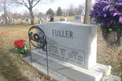
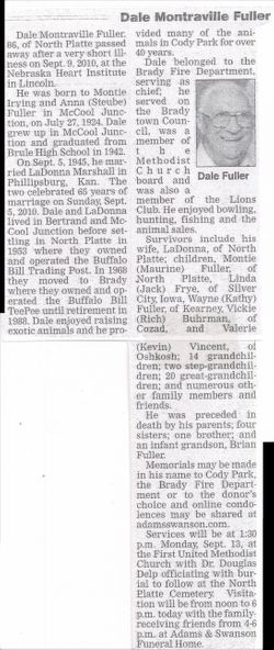
Dale Montraville Fuller
| Birth | : | 24 Jul 1924 McCool Junction, York County, Nebraska, USA |
| Death | : | 9 Sep 2010 Lincoln, Lancaster County, Nebraska, USA |
| Burial | : | Highland Cemetery, Wichita, Sedgwick County, USA |
| Coordinate | : | 37.7028008, -97.3007965 |
| Description | : | Buried Sept 13,2010 Lot 982 Section D Space- 01 Dale Montraville Fuller July 27,1924-Sept 9,2010 Dale Montraville Fuller, age 86, of North Platte passed away September 9, 2010 at the Nebraska Heart Institute in Lincoln, NE. He was born to Montie Irving and Anna (Steube) Fuller in McCool Junction, NE on July 27, 1924. Dale grew up in McCool Junction and graduated from Brule High School in 1942. On September 5, 1945 he married LaDonna Marshall in Phillipsburg, Kansas. The two celebrated 65 years of marriage on Sunday, September 5, 2010. Dale and LaDonna lived in Bertrand and McCool Junction before settling in North Platte in... Read More |
frequently asked questions (FAQ):
-
Where is Dale Montraville Fuller's memorial?
Dale Montraville Fuller's memorial is located at: Highland Cemetery, Wichita, Sedgwick County, USA.
-
When did Dale Montraville Fuller death?
Dale Montraville Fuller death on 9 Sep 2010 in Lincoln, Lancaster County, Nebraska, USA
-
Where are the coordinates of the Dale Montraville Fuller's memorial?
Latitude: 37.7028008
Longitude: -97.3007965
Family Members:
Parent

Spouse

Siblings
Flowers:


Nearby Cemetories:
1. Temple Emanuel Cemetery
Wichita, Sedgwick County, USA
Coordinate: 37.7014000, -97.3008000
2. Maple Grove Cemetery
Wichita, Sedgwick County, USA
Coordinate: 37.7036018, -97.2949982
3. Saint James Episcopal Church Columbarium
Wichita, Sedgwick County, USA
Coordinate: 37.6865600, -97.2930000
4. Mission Chapel Mausoleum
Wichita, Sedgwick County, USA
Coordinate: 37.7231200, -97.2955100
5. White Chapel Memorial Gardens
Wichita, Sedgwick County, USA
Coordinate: 37.7162018, -97.2806015
6. East Heights United Methodist Memorial Garden
Wichita, Sedgwick County, USA
Coordinate: 37.6854100, -97.2845500
7. Old Mission Mausoleum
Wichita, Sedgwick County, USA
Coordinate: 37.7242600, -97.2967400
8. Old Mission Cemetery
Wichita, Sedgwick County, USA
Coordinate: 37.7243996, -97.2964020
9. Wichita Hebrew Cemetery
Wichita, Sedgwick County, USA
Coordinate: 37.7201004, -97.2798004
10. Calvary Cemetery
Wichita, Sedgwick County, USA
Coordinate: 37.6781006, -97.2949982
11. Wichita Park Cemetery and Mausoleum
Wichita, Sedgwick County, USA
Coordinate: 37.7277985, -97.2960968
12. Saint Johns Episcopal Church Columbarium
Wichita, Sedgwick County, USA
Coordinate: 37.6918950, -97.3339670
13. Shirley Tilford Memorial Garden
Wichita, Sedgwick County, USA
Coordinate: 37.6942700, -97.3359600
14. Mount Saint Mary Convent Cemetery
Wichita, Sedgwick County, USA
Coordinate: 37.6704000, -97.2904000
15. Saint Stephen's Episcopal Church Columbarium
Wichita, Sedgwick County, USA
Coordinate: 37.6999272, -97.2505590
16. Adorers of The Blood of Christ Convent Cemetery
Wichita, Sedgwick County, USA
Coordinate: 37.6677700, -97.3787800
17. Cornerstone Pentecostal Holiness Church
Wichita, Sedgwick County, USA
Coordinate: 37.6578700, -97.3705700
18. Pierpont Cemetery
Sedgwick County, USA
Coordinate: 37.7011400, -97.2077500
19. Ascension Cemetery
Bel Aire, Sedgwick County, USA
Coordinate: 37.7675018, -97.2533035
20. Greenwich Cemetery
Wichita, Sedgwick County, USA
Coordinate: 37.7518997, -97.2266998
21. Lutheran Cemetery
Wichita, Sedgwick County, USA
Coordinate: 37.7664986, -97.2443008
22. Kensington Gardens Cemetery
Wichita, Sedgwick County, USA
Coordinate: 37.7230988, -97.2040024
23. Lakeview Cemetery & Mausoleum
Wichita, Sedgwick County, USA
Coordinate: 37.7086601, -97.1978989
24. Reflection Pointe Cemetery
Wichita, Sedgwick County, USA
Coordinate: 37.6344800, -97.2264100