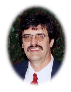
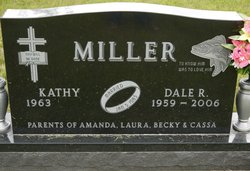
Dale R. Miller
| Birth | : | 21 Sep 1959 Watertown, Codington County, South Dakota, USA |
| Death | : | 12 Mar 2006 Watertown, Codington County, South Dakota, USA |
| Burial | : | Sand Spring Cemetery, Friendsville, Garrett County, USA |
| Coordinate | : | 39.6711006, -79.4597015 |
| Description | : | Dale R. Miller, age 46, of Watertown, SD, passed away on Sunday, March 12, 2006 in his home. Funeral services were held at 10:00 a.m., Thursday, March 16, 2006 at the Immaculate Conception Church with Father James Bream officiating. Interment in St. Mary's Cemetery, Watertown, SD. Music was furnished by the Immaculate Conception Church Choir. Visitation was on Wednesday, from 4-8 p.m. with a scripture service at 7:00 p.m. and a Rosary at 7:45 p.m. at the Wight, Comes & Sogn Funeral Chapel. Pallbearers were Gary Brandsrud, Bob Dahl, Michael Price, Steve Frerichs, Shannon Morris, and Justin Layton.... Read More |
frequently asked questions (FAQ):
-
Where is Dale R. Miller's memorial?
Dale R. Miller's memorial is located at: Sand Spring Cemetery, Friendsville, Garrett County, USA.
-
When did Dale R. Miller death?
Dale R. Miller death on 12 Mar 2006 in Watertown, Codington County, South Dakota, USA
-
Where are the coordinates of the Dale R. Miller's memorial?
Latitude: 39.6711006
Longitude: -79.4597015
Family Members:
Parent
Flowers:
Nearby Cemetories:
1. Sand Spring Cemetery
Friendsville, Garrett County, USA
Coordinate: 39.6711006, -79.4597015
2. Humberson Cemetery
Friendsville, Garrett County, USA
Coordinate: 39.6768200, -79.4342100
3. VanSickle Cemetery
Hazelton, Preston County, USA
Coordinate: 39.6800840, -79.4850690
4. Blooming Rose Church Cemetery
Friendsville, Garrett County, USA
Coordinate: 39.6558900, -79.4399500
5. Webb Chapel Cemetery
Hazelton, Preston County, USA
Coordinate: 39.6648210, -79.4915600
6. Cuppett-Falkner Cemetery
Hazelton, Preston County, USA
Coordinate: 39.6493900, -79.4879280
7. Andrew Friend Cemetery
Friendsville, Garrett County, USA
Coordinate: 39.6631700, -79.4197000
8. Emberson Cemetery
Friendsville, Garrett County, USA
Coordinate: 39.6716995, -79.4150009
9. Asher Glade Cemetery
Friendsville, Garrett County, USA
Coordinate: 39.7047005, -79.4443970
10. Friend Family Graveyard
Friendsville, Garrett County, USA
Coordinate: 39.6622000, -79.4124200
11. Keeler Glade Cemetery
Garrett County, USA
Coordinate: 39.6308000, -79.4768000
12. Steele Cemetery
Friendsville, Garrett County, USA
Coordinate: 39.6650009, -79.4005966
13. Savage Cemetery
Hazelton, Preston County, USA
Coordinate: 39.6323470, -79.5003360
14. Markleysburg Cemetery
Markleysburg, Fayette County, USA
Coordinate: 39.7253000, -79.4469600
15. Frazee Ridge Cemetery
Garrett County, USA
Coordinate: 39.7114600, -79.4099200
16. Mitchell Cemetery
Glade Farms, Preston County, USA
Coordinate: 39.6925470, -79.5294020
17. Great Crossings Cemetery
Garrett County, USA
Coordinate: 39.7127991, -79.4067001
18. Myers Frazee Cemetery
Henry Clay Township, Fayette County, USA
Coordinate: 39.7299800, -79.4517700
19. Thomas Cemetery
Markleysburg, Fayette County, USA
Coordinate: 39.7322006, -79.4574966
20. Cuppett - Teets Cemetery
Glade Farms, Preston County, USA
Coordinate: 39.7101700, -79.5225000
21. Glover Cemetery
Markleysburg, Fayette County, USA
Coordinate: 39.7330589, -79.4530563
22. Jeffreys Cemetery
Hazelton, Preston County, USA
Coordinate: 39.6446160, -79.5351210
23. Andrew Umble Cemetery
Markleysburg, Fayette County, USA
Coordinate: 39.7385200, -79.4536100
24. Sisler Cemetery
Mountain Dale, Preston County, USA
Coordinate: 39.6081009, -79.4938965


