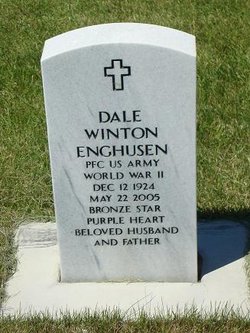
Dale Winton Enghusen
| Birth | : | 18 Dec 1924 Poplar, Roosevelt County, Montana, USA |
| Death | : | 22 May 2005 Billings, Yellowstone County, Montana, USA |
| Burial | : | Wallabadah General Cemetery, Wallabadah, Liverpool Plains Shire, Australia |
| Coordinate | : | -31.5463600, 150.8253800 |
| Plot | : | Section A, Site R5-7 |
| Inscription | : | PFC US ARMY WORLD WAR II BRONZE STAR PURPLE HEART BELOVED HUSBAND AND FATHER |
| Description | : | Suggested Edit Obituary from Billings Gazette 26 May 2005 DALE WINTON ENGHUSEN Dale Winton Enghusen, 80, died Sunday, May 22, 2005, of cancer. He was born December 18, 1924, to George W and Alpha (Wicks) Enghusen in Poplar, Montana. The family moved to Brockton in 1932 and then to Sidney, Montana in 1935, where Dale completed his high school education. In 1943, Dale entered the Army. He was trained as a communications specialist and served in the 328th Field Artillery with the 85th "Custer" Division, first in Africa and then in Italy in WWII. In October 1943, Dale... Read More |
frequently asked questions (FAQ):
-
Where is Dale Winton Enghusen's memorial?
Dale Winton Enghusen's memorial is located at: Wallabadah General Cemetery, Wallabadah, Liverpool Plains Shire, Australia.
-
When did Dale Winton Enghusen death?
Dale Winton Enghusen death on 22 May 2005 in Billings, Yellowstone County, Montana, USA
-
Where are the coordinates of the Dale Winton Enghusen's memorial?
Latitude: -31.5463600
Longitude: 150.8253800
Family Members:
Spouse
Flowers:
Nearby Cemetories:
1. Wallabadah General Cemetery
Wallabadah, Liverpool Plains Shire, Australia
Coordinate: -31.5463600, 150.8253800
2. Quirindi General Cemetery
Quirindi, Liverpool Plains Shire, Australia
Coordinate: -31.5182600, 150.6869300
3. Quirindi Lawn Cemetery
Quirindi, Liverpool Plains Shire, Australia
Coordinate: -31.5182600, 150.6869300
4. Old Quirindi Burial Ground (Defunct)
Quirindi, Liverpool Plains Shire, Australia
Coordinate: -31.5177689, 150.6779610
5. Willow Tree Cemetery
Willow Tree, Liverpool Plains Shire, Australia
Coordinate: -31.6533740, 150.7283810
6. Willow Tree Catholic Cemetery
Willow Tree, Liverpool Plains Shire, Australia
Coordinate: -31.6646200, 150.7267100
7. Quipolly General Cemetery
Quipolly, Liverpool Plains Shire, Australia
Coordinate: -31.4480100, 150.6145450
8. Werris Creek General Cemetery
Werris Creek, Liverpool Plains Shire, Australia
Coordinate: -31.3342800, 150.6535400
9. Currabubula Cemetery
Currabubula, Liverpool Plains Shire, Australia
Coordinate: -31.2639201, 150.7484767
10. Walhallow Cemetery
Caroona, Liverpool Plains Shire, Australia
Coordinate: -31.4029460, 150.4242460
11. Breeza General Cemetery
Breeza, Gunnedah Shire, Australia
Coordinate: -31.2498300, 150.4610290
12. Spring Ridge Cemetery
Spring Ridge, Liverpool Plains Shire, Australia
Coordinate: -31.3874828, 150.2835445
13. Blackville Catholic Cemetery
Blackville, Liverpool Plains Shire, Australia
Coordinate: -31.6440290, 150.2371790
14. Colly Blue Cemetery
Colly Blue, Liverpool Plains Shire, Australia
Coordinate: -31.4579540, 150.1393320
15. Curlewis Cemetery
Curlewis, Gunnedah Shire, Australia
Coordinate: -31.1268010, 150.2691040
16. Carroll General Cemetery
Carroll, Gunnedah Shire, Australia
Coordinate: -30.9947500, 150.4495200
17. Muswellbrook Cemetery
Muswellbrook, Muswellbrook Shire, Australia
Coordinate: -32.2620530, 150.9004740
18. Muswellbrook War Cemetery
Muswellbrook, Muswellbrook Shire, Australia
Coordinate: -32.2631300, 150.9013900
19. St James Church Cemetery
Muswellbrook, Muswellbrook Shire, Australia
Coordinate: -32.2641590, 150.8900180
20. Sisters of Mercy Cemetery
Gunnedah, Gunnedah Shire, Australia
Coordinate: -30.9805057, 150.2607847
21. Wybong Cemetery
Wybong, Muswellbrook Shire, Australia
Coordinate: -32.2771470, 150.6375970
22. Gunnedah Memorial Park
Gunnedah, Gunnedah Shire, Australia
Coordinate: -30.9929200, 150.2320660
23. Gunnedah General Cemetery
Gunnedah, Gunnedah Shire, Australia
Coordinate: -30.9840660, 150.2425840
24. Giants Creek Cemetery
Sandy Hollow, Muswellbrook Shire, Australia
Coordinate: -32.3249630, 150.5482480


