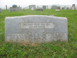
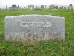
Damon Goble Atkins
| Birth | : | 10 Jul 1911 |
| Death | : | 26 Feb 2001 Salem, Salem City, Virginia, USA |
| Burial | : | Cannaday Cemetery, Floyd, Floyd County, USA |
| Coordinate | : | 36.9255980, -80.2040820 |
| Description | : | Roanoke Times, Tuesday, February 27, 2001 Page B2, Column 2 Damon Goble Atkins Damon Goble Atkins, 89, of Salem, passed away Monday, February 26, 2001 in a Salem hospital. He is survived by eleven children. Donald and Carol Atkins, Roanoke, Shirley and Ervin Richards, Chicago, Libby and Dave White, Chattanooga, Julia and Howard Alley Daniels, W. Va., Diane and John McNeil, Montvale, Gracie and Billy Conner, Salem, Johnny Mills, Roanoke, Clyde and Joyce Mills, N. C., Andrew and Betty Atkins, Salem, Anthony Atkins, Dillyn, Va., Steve and Christine Mills, Sylvian, W. Va., 38 grandchildren and 37 great grandchildren; also two sisters, Virgie Cox,... Read More |
frequently asked questions (FAQ):
-
Where is Damon Goble Atkins's memorial?
Damon Goble Atkins's memorial is located at: Cannaday Cemetery, Floyd, Floyd County, USA.
-
When did Damon Goble Atkins death?
Damon Goble Atkins death on 26 Feb 2001 in Salem, Salem City, Virginia, USA
-
Where are the coordinates of the Damon Goble Atkins's memorial?
Latitude: 36.9255980
Longitude: -80.2040820
Family Members:
Parent
Spouse
Siblings
Children
Flowers:
Nearby Cemetories:
1. Cannaday Cemetery
Floyd, Floyd County, USA
Coordinate: 36.9255980, -80.2040820
2. West Cemetery
Smart, Floyd County, USA
Coordinate: 36.9365630, -80.1976930
3. Underwood Cemetery
Floyd, Floyd County, USA
Coordinate: 36.9128780, -80.2031780
4. Yeatts Cemetery
Pizarro, Floyd County, USA
Coordinate: 36.9389000, -80.2199000
5. Brammer Cemetery
Floyd, Floyd County, USA
Coordinate: 36.9163984, -80.2261629
6. Gillespie Cemetery
Floyd, Floyd County, USA
Coordinate: 36.9389229, -80.1848935
7. Radford Cemetery
Floyd, Floyd County, USA
Coordinate: 36.9389190, -80.1848500
8. Harvestwood Cemetery
Floyd, Floyd County, USA
Coordinate: 36.9277955, -80.2352426
9. Graham Cemetery
Pizarro, Floyd County, USA
Coordinate: 36.9172780, -80.2387120
10. Beckner Cemetery #2
Floyd County, USA
Coordinate: 36.9517870, -80.1855830
11. Sweeney Cemetery
Floyd, Floyd County, USA
Coordinate: 36.9509640, -80.2243460
12. County Line Primitive Baptist Church Cemetery
Floyd County, USA
Coordinate: 36.9032070, -80.2293160
13. Agee Family Cemetery
Mabry Mill, Floyd County, USA
Coordinate: 36.9032070, -80.2293160
14. Little River Cemetery
Pizarro, Floyd County, USA
Coordinate: 36.9520520, -80.2252900
15. Shortt Cemetery
Floyd, Floyd County, USA
Coordinate: 36.8983120, -80.2290800
16. Peters Family Cemetery
Floyd, Floyd County, USA
Coordinate: 36.9578403, -80.1854498
17. Huff Cemetery
Floyd County, USA
Coordinate: 36.9221500, -80.2512650
18. Barton Cemetery
Floyd, Floyd County, USA
Coordinate: 36.8920230, -80.2278370
19. Shortt Cemetery
Floyd, Floyd County, USA
Coordinate: 36.8894120, -80.2222810
20. Floyd County Farm Cemetery
Floyd, Floyd County, USA
Coordinate: 36.9606960, -80.2320990
21. Boyd-Nolen Cemetery
Franklin County, USA
Coordinate: 36.8798890, -80.1855590
22. Strickler Cemetery
Floyd, Floyd County, USA
Coordinate: 36.9609570, -80.2451350
23. Claytor Family Cemetery
Copper Hill, Floyd County, USA
Coordinate: 36.9736138, -80.2123514
24. Elkanah Thompson Cemetery
Pizarro, Floyd County, USA
Coordinate: 36.9580790, -80.1558260

