
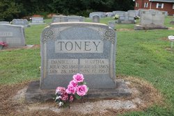
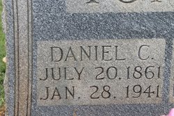
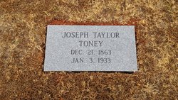
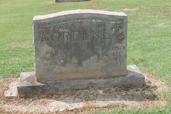
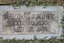
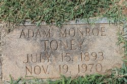
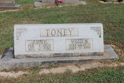
Daniel C Toney
| Birth | : | 20 Jul 1861 Rutherford County, North Carolina, USA |
| Death | : | 28 Jan 1941 Rutherford County, North Carolina, USA |
| Burial | : | St. Mary's Churchyard, Cholsey, South Oxfordshire District, England |
| Coordinate | : | 51.5788078, -1.1589500 |
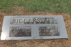
| Description | : | Daniel Toney in the North Carolina, Death Certificates, 1909-1976 Name: Daniel Toney Gender: Male Race: White Age: 80 Birth Date: 20 Jul 1861 Birth Place: Rutherford Death Date: 28 Jan 1942 Death Location: Golden Valley, Rutherford, North Carolina Spouse's Name: Martha Biggerstaff Father's name: Draper Toney Mother's name: Huldah Luckadoo |
frequently asked questions (FAQ):
-
Where is Daniel C Toney's memorial?
Daniel C Toney's memorial is located at: St. Mary's Churchyard, Cholsey, South Oxfordshire District, England.
-
When did Daniel C Toney death?
Daniel C Toney death on 28 Jan 1941 in Rutherford County, North Carolina, USA
-
Where are the coordinates of the Daniel C Toney's memorial?
Latitude: 51.5788078
Longitude: -1.1589500
Family Members:
Parent

Spouse

Siblings

Children

Flowers:


Nearby Cemetories:
1. St. Mary's Churchyard
Cholsey, South Oxfordshire District, England
Coordinate: 51.5788078, -1.1589500
2. St. John the Baptist South Moreton
South Moreton, South Oxfordshire District, England
Coordinate: 51.5881630, -1.1895850
3. St. John the Baptist Church (Defunct)
Mongwell, South Oxfordshire District, England
Coordinate: 51.5860980, -1.1233580
4. St. Mary's Churchyard
North Stoke, South Oxfordshire District, England
Coordinate: 51.5714910, -1.1228080
5. South Moreton Strict Baptist Chapel
South Moreton, South Oxfordshire District, England
Coordinate: 51.5900300, -1.1924310
6. St Michael's Cemetery
Aston Tirrold, South Oxfordshire District, England
Coordinate: 51.5730994, -1.1967145
7. St John the Baptist
Moulsford, South Oxfordshire District, England
Coordinate: 51.5531050, -1.1482640
8. All Saints Churchyard
Aston Upthorpe, South Oxfordshire District, England
Coordinate: 51.5715900, -1.2037500
9. St. Leonard's Churchyard
Wallingford, South Oxfordshire District, England
Coordinate: 51.5972711, -1.1230712
10. St. Mary-le-More Churchyard
Wallingford, South Oxfordshire District, England
Coordinate: 51.5993878, -1.1249488
11. All Saints Churchyard
North Moreton, South Oxfordshire District, England
Coordinate: 51.6021922, -1.1898247
12. All Hallows Graveyard
Wallingford, South Oxfordshire District, England
Coordinate: 51.6020520, -1.1242267
13. Saint Peter's Churchyard
Wallingford, South Oxfordshire District, England
Coordinate: 51.6005819, -1.1215970
14. Saint James Churchyard
Brightwell cum Sotwell, South Oxfordshire District, England
Coordinate: 51.6120200, -1.1549800
15. St Andrew Churchyard
South Stoke, South Oxfordshire District, England
Coordinate: 51.5479065, -1.1377167
16. St Mary Magdalene Churchyard
Crowmarsh Gifford, South Oxfordshire District, England
Coordinate: 51.5992169, -1.1139564
17. St. Agatha New Churchyard
Brightwell cum Sotwell, South Oxfordshire District, England
Coordinate: 51.6131480, -1.1665480
18. Wallingford Cemetery
Wallingford, South Oxfordshire District, England
Coordinate: 51.6058200, -1.1232000
19. St. Mary the Virgin Cemetery
Ipsden, South Oxfordshire District, England
Coordinate: 51.5674164, -1.0866686
20. St. Michael Churchyard
Blewbury, Vale of White Horse District, England
Coordinate: 51.5693100, -1.2346100
21. St. Helen's Churchyard
Benson, South Oxfordshire District, England
Coordinate: 51.6200200, -1.1127400
22. St. Helen Churchyard Extension
Benson, South Oxfordshire District, England
Coordinate: 51.6201400, -1.1121200
23. Benson War Memorial
Benson, South Oxfordshire District, England
Coordinate: 51.6207890, -1.1108700
24. St Andrew's Church
East Hagbourne, South Oxfordshire District, England
Coordinate: 51.5901700, -1.2427700