
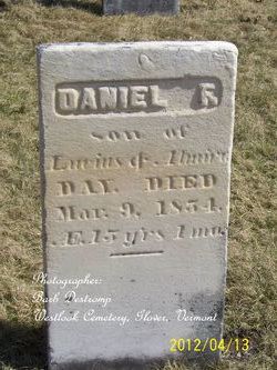
Daniel F. Day
| Birth | : | 1839 |
| Death | : | 9 Mar 1854 Greensboro, Orleans County, Vermont, USA |
| Burial | : | Oak Grove Cemetery, Le Roy, McLean County, USA |
| Coordinate | : | 40.3391991, -88.7358017 |
| Description | : | 15 yrs, 1 mo., son of Lucius and Almira Day. |
frequently asked questions (FAQ):
-
Where is Daniel F. Day's memorial?
Daniel F. Day's memorial is located at: Oak Grove Cemetery, Le Roy, McLean County, USA.
-
When did Daniel F. Day death?
Daniel F. Day death on 9 Mar 1854 in Greensboro, Orleans County, Vermont, USA
-
Where are the coordinates of the Daniel F. Day's memorial?
Latitude: 40.3391991
Longitude: -88.7358017
Family Members:
Parent

Siblings
Flowers:


Nearby Cemetories:
1. Oak Grove Cemetery
Le Roy, McLean County, USA
Coordinate: 40.3391991, -88.7358017
2. Howard Cemetery
Le Roy, McLean County, USA
Coordinate: 40.3384514, -88.7318115
3. Gilmore Cemetery
Le Roy, McLean County, USA
Coordinate: 40.3403460, -88.7923840
4. Deffenbaugh Family Cemetery
Le Roy, McLean County, USA
Coordinate: 40.3017502, -88.7753067
5. Barnes Cemetery
Ellsworth, McLean County, USA
Coordinate: 40.4081001, -88.6931000
6. Rutledge Cemetery
Le Roy, McLean County, USA
Coordinate: 40.3414993, -88.8386002
7. Love Cemetery
Sabina, McLean County, USA
Coordinate: 40.3918000, -88.6563200
8. Dawson Cemetery
Ellsworth, McLean County, USA
Coordinate: 40.4197006, -88.7117004
9. Frankeberger Cemetery
Ellsworth, McLean County, USA
Coordinate: 40.4239006, -88.7328033
10. Lebo Cemetery
Downs, McLean County, USA
Coordinate: 40.4075012, -88.8091660
11. Garr Cemetery
Downs, McLean County, USA
Coordinate: 40.4008500, -88.8344190
12. Rucker Chapel Cemetery
Wapella, DeWitt County, USA
Coordinate: 40.2599983, -88.8152771
13. Arrowsmith Township Cemetery
Arrowsmith, McLean County, USA
Coordinate: 40.4282990, -88.6658020
14. Creel Cemetery
McLean County, USA
Coordinate: 40.4223180, -88.8213300
15. Walden Family Cemetery
DeWitt County, USA
Coordinate: 40.2527060, -88.8234110
16. Johnson Cemetery
Solomon, DeWitt County, USA
Coordinate: 40.2344780, -88.7929611
17. Campground Cemetery
Farmer City, DeWitt County, USA
Coordinate: 40.2299995, -88.6785965
18. Hopewell Cemetery
Downs, McLean County, USA
Coordinate: 40.3996240, -88.8712190
19. City Cemetery
Farmer City, DeWitt County, USA
Coordinate: 40.2397232, -88.6447220
20. Polen Family Cemetery
Solomon, DeWitt County, USA
Coordinate: 40.2359700, -88.8211700
21. Pleasant Grove Cemetery
Downs, McLean County, USA
Coordinate: 40.4285202, -88.8456802
22. Peasley Cemetery
Downs, McLean County, USA
Coordinate: 40.3450012, -88.8963928
23. Hoover Cemetery
McLean County, USA
Coordinate: 40.4485470, -88.8090560
24. Walters Cemetery
Solomon, DeWitt County, USA
Coordinate: 40.2317009, -88.8208008