
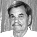

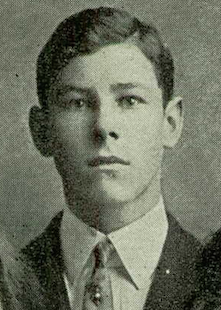
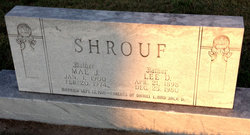
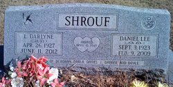
Daniel Lee Shrouf
| Birth | : | 3 Sep 1923 Concordia, Cloud County, Kansas, USA |
| Death | : | 9 Feb 2009 Junction City, Geary County, Kansas, USA |
| Burial | : | Mayflower Cemetery, Duxbury, Plymouth County, USA |
| Coordinate | : | 42.0331001, -70.6952972 |
| Description | : | Daniel Lee Shrouf , 85, of Junction City, died Monday, Feb. 9, 2009, at the Geary County Hospital. The family provided some of the following information. Daniel was born Sept. 3, 1923, in Concordia, to Lee D. and Mae Jesse (Roe) Shrouf. He graduated in 1941 from Concordia High School and served in the U.S. Army 1943-1946 with the 20th Armored Division, Central Europe Campaign as a scout. He married Lillian Darlyne Drury April 16, 1949. He was a35-year employee of the Kansas Highway Commission and Kansas Department of Transportation as a civil engineer, retiring in 1981 due to heart problems. Dan was a... Read More |
frequently asked questions (FAQ):
-
Where is Daniel Lee Shrouf's memorial?
Daniel Lee Shrouf's memorial is located at: Mayflower Cemetery, Duxbury, Plymouth County, USA.
-
When did Daniel Lee Shrouf death?
Daniel Lee Shrouf death on 9 Feb 2009 in Junction City, Geary County, Kansas, USA
-
Where are the coordinates of the Daniel Lee Shrouf's memorial?
Latitude: 42.0331001
Longitude: -70.6952972
Family Members:
Parent
Spouse
Children
Flowers:


Nearby Cemetories:
1. Smith Tomb
Duxbury, Plymouth County, USA
Coordinate: 42.0347870, -70.6912280
2. Standish Burial Ground
Duxbury, Plymouth County, USA
Coordinate: 42.0250664, -70.6875076
3. Saint John the Evangelist Episcopal Cemetery
Duxbury, Plymouth County, USA
Coordinate: 42.0368300, -70.6742700
4. Weston Tomb
Duxbury, Plymouth County, USA
Coordinate: 42.0689160, -70.7191710
5. Dingley Cemetery
Duxbury, Plymouth County, USA
Coordinate: 42.0657997, -70.7272034
6. Evergreen Cemetery
Kingston, Plymouth County, USA
Coordinate: 41.9944800, -70.7317400
7. Old Burying Ground
Kingston, Plymouth County, USA
Coordinate: 41.9943800, -70.7321300
8. Watson Cemetery
Plymouth, Plymouth County, USA
Coordinate: 42.0119490, -70.6358560
9. Baker Cemetery
Marshfield, Plymouth County, USA
Coordinate: 42.0837700, -70.7157200
10. Old Winslow Burying Ground
Marshfield, Plymouth County, USA
Coordinate: 42.0857000, -70.6808000
11. Ashdod Cemetery
Duxbury, Plymouth County, USA
Coordinate: 42.0670600, -70.7526300
12. Chapel Burying Ground
Pembroke, Plymouth County, USA
Coordinate: 42.0230600, -70.7715700
13. Saint Joseph Cemetery
Kingston, Plymouth County, USA
Coordinate: 41.9846992, -70.7380981
14. Chapel Cemetery
Marshfield, Plymouth County, USA
Coordinate: 42.0916214, -70.7090836
15. Cedar Grove Cemetery
Marshfield, Plymouth County, USA
Coordinate: 42.0918045, -70.7086487
16. Sachem Lodge Cemetery
Pembroke, Plymouth County, USA
Coordinate: 42.0577500, -70.7773900
17. Howland Cemetery
Marshfield, Plymouth County, USA
Coordinate: 42.0980500, -70.7146000
18. Pleasant Mountain Pet Rest
Plymouth, Plymouth County, USA
Coordinate: 41.9630360, -70.6918110
19. Christ Episcopal Church Columbarium
Plymouth, Plymouth County, USA
Coordinate: 41.9625100, -70.6737500
20. Pine Grove Cemetery
Pembroke, Plymouth County, USA
Coordinate: 42.0847015, -70.7641983
21. Vine Hills Cemetery
Plymouth, Plymouth County, USA
Coordinate: 41.9556200, -70.6792800
22. Beth Jacob Cemetery
Plymouth, Plymouth County, USA
Coordinate: 41.9553300, -70.6792600
23. Coles Hill Burial Ground
Plymouth, Plymouth County, USA
Coordinate: 41.9573330, -70.6624000
24. Burial Hill
Plymouth, Plymouth County, USA
Coordinate: 41.9559822, -70.6656876