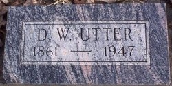
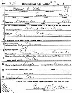
Daniel Wilson Utter
| Birth | : | 22 Sep 1861 Harrison County, Missouri, USA |
| Death | : | 20 Sep 1947 Flathead County, Montana, USA |
| Burial | : | Resurrection Cemetery, Wyoming, Kent County, USA |
| Coordinate | : | 42.8905983, -85.6819000 |
| Description | : | Parents: Richard F. Utter, Lydia Jane Neff Spouse: Lucinda Robinson Montana, Death Index NAME: Daniel Utter DEATH DATE: 21 Sep 1947 DEATH COUNTY: Flathead |
frequently asked questions (FAQ):
-
Where is Daniel Wilson Utter's memorial?
Daniel Wilson Utter's memorial is located at: Resurrection Cemetery, Wyoming, Kent County, USA.
-
When did Daniel Wilson Utter death?
Daniel Wilson Utter death on 20 Sep 1947 in Flathead County, Montana, USA
-
Where are the coordinates of the Daniel Wilson Utter's memorial?
Latitude: 42.8905983
Longitude: -85.6819000
Family Members:
Parent
Siblings
Children
Flowers:
Nearby Cemetories:
1. Resurrection Cemetery
Wyoming, Kent County, USA
Coordinate: 42.8905983, -85.6819000
2. Holy Trinity Columbarium
Wyoming, Kent County, USA
Coordinate: 42.8669010, -85.6847490
3. Rest Lawn Memorial Park
Grand Rapids, Kent County, USA
Coordinate: 42.9007988, -85.6438980
4. Pine Hill Cemetery
Kentwood, Kent County, USA
Coordinate: 42.8675003, -85.6363983
5. Oak Grove Cemetery
Grand Rapids, Kent County, USA
Coordinate: 42.9136009, -85.6314011
6. Woodlawn Cemetery
Grand Rapids, Kent County, USA
Coordinate: 42.9160995, -85.6303024
7. Maple Grove Cemetery
Kentwood, Kent County, USA
Coordinate: 42.9033300, -85.6203400
8. Garfield Park Cemetery
Grand Rapids, Kent County, USA
Coordinate: 42.9221992, -85.6307983
9. Grandville Cemetery
Grandville, Kent County, USA
Coordinate: 42.9043999, -85.7514038
10. Oakhill Cemetery
Grand Rapids, Kent County, USA
Coordinate: 42.9411011, -85.6517029
11. Kent Memorial Gardens
Byron Center, Kent County, USA
Coordinate: 42.8356018, -85.6883011
12. Sleepy Hollow Pet Cemetery and Crematory
Byron Center, Kent County, USA
Coordinate: 42.8477040, -85.7329940
13. Saint Andrews Catholic Cemetery
Grand Rapids, Kent County, USA
Coordinate: 42.9463997, -85.6567001
14. Blain Cemetery
Cutlerville, Kent County, USA
Coordinate: 42.8414001, -85.6335983
15. Grace Episcopal Church Columbarium
Grand Rapids, Kent County, USA
Coordinate: 42.9413390, -85.6242730
16. Winchester Cemetery
Byron Center, Kent County, USA
Coordinate: 42.8246994, -85.6980972
17. Boynton Cemetery
Byron Center, Kent County, USA
Coordinate: 42.8377991, -85.7433014
18. Westminster Presbyterian Church Columbarium
Grand Rapids, Kent County, USA
Coordinate: 42.9619070, -85.6646760
19. First United Methodist Church Columbarium
Grand Rapids, Kent County, USA
Coordinate: 42.9634200, -85.6633300
20. Central Reformed Church Crypt
Grand Rapids, Kent County, USA
Coordinate: 42.9634410, -85.6563430
21. Gerald R Ford Museum
Grand Rapids, Kent County, USA
Coordinate: 42.9668140, -85.6771000
22. Fulton Street Cemetery
Grand Rapids, Kent County, USA
Coordinate: 42.9639200, -85.6486400
23. River Bend Cemetery
Walker, Kent County, USA
Coordinate: 42.9352989, -85.7750015
24. Weaver Cemetery
Byron Township, Kent County, USA
Coordinate: 42.8041992, -85.6828003


