

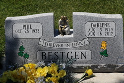
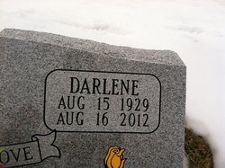
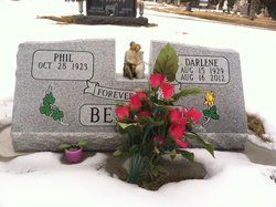
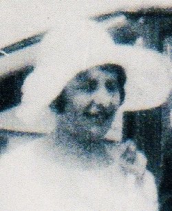
Darlene Elizabeth Enright Bestgen
| Birth | : | 15 Aug 1929 Aberdeen, Brown County, South Dakota, USA |
| Death | : | 16 Aug 2012 Sturgis, Meade County, South Dakota, USA |
| Burial | : | Saint Aloysius Cemetery, Sturgis, Meade County, USA |
| Coordinate | : | 44.4141340, -103.5193420 |
| Description | : | Darlene Enright Bestgen, 83, Whitewood, died Thursday, August 16, 2012 at the Sturgis Regional Hospital. Visitation will be 3:30 p.m. until 9 p.m. Monday, with rosary services beginning at 7 p.m. at the Kinkade Funeral Chapel in Sturgis. Funeral services will be 10 a.m. Tuesday, August 21, 2012 at St. Martin's Chapel in Sturgis with Fr. Christopher Hathaway officiating. Burial follows at the St. Aloysius Cemetery. Memorials have been established to Right to Life and the Fraternity of St. Peter. Darlene requested Masses be offered for her soul in place of flowers. Darlene was born August 15, 1929, at Aberdeen, SD, to Earl and... Read More |
frequently asked questions (FAQ):
-
Where is Darlene Elizabeth Enright Bestgen's memorial?
Darlene Elizabeth Enright Bestgen's memorial is located at: Saint Aloysius Cemetery, Sturgis, Meade County, USA.
-
When did Darlene Elizabeth Enright Bestgen death?
Darlene Elizabeth Enright Bestgen death on 16 Aug 2012 in Sturgis, Meade County, South Dakota, USA
-
Where are the coordinates of the Darlene Elizabeth Enright Bestgen's memorial?
Latitude: 44.4141340
Longitude: -103.5193420
Family Members:
Parent

Spouse

Siblings
Flowers:


Nearby Cemetories:
1. Saint Aloysius Cemetery
Sturgis, Meade County, USA
Coordinate: 44.4141340, -103.5193420
2. Bear Butte Cemetery
Sturgis, Meade County, USA
Coordinate: 44.4111595, -103.4947968
3. Fort Meade National Cemetery
Sturgis, Meade County, USA
Coordinate: 44.4021988, -103.4757996
4. Curley Grimes Memorial Cemetery
Sturgis, Meade County, USA
Coordinate: 44.3764500, -103.4691300
5. Black Hills National Cemetery
Sturgis, Meade County, USA
Coordinate: 44.3689003, -103.4753036
6. Crook City Cemetery
Crook City, Lawrence County, USA
Coordinate: 44.4432100, -103.6241500
7. Whitewood Cemetery
Whitewood, Lawrence County, USA
Coordinate: 44.4617820, -103.6330030
8. Oak Ridge Cemetery
Deadwood, Lawrence County, USA
Coordinate: 44.3891983, -103.6766968
9. Galena Cemetery
Galena, Lawrence County, USA
Coordinate: 44.3349220, -103.6438410
10. Anderson Cemetery
Lawrence County, USA
Coordinate: 44.4747009, -103.6896973
11. Saint Ambrose Cemetery
Deadwood, Lawrence County, USA
Coordinate: 44.3821983, -103.7266998
12. Mount Moriah Cemetery
Deadwood, Lawrence County, USA
Coordinate: 44.3760986, -103.7253036
13. Pleasant Valley Cemetery
Tilford, Meade County, USA
Coordinate: 44.3192500, -103.3531160
14. Little Dane Cemetery
Saint Onge, Lawrence County, USA
Coordinate: 44.5252500, -103.6705540
15. Roubaix Cemetery
Roubaix, Lawrence County, USA
Coordinate: 44.2789380, -103.6656600
16. South Lead Cemetery
Lead, Lawrence County, USA
Coordinate: 44.3478510, -103.7606260
17. Gate of Heaven Cemetery
Saint Onge, Lawrence County, USA
Coordinate: 44.5353000, -103.7237000
18. Piedmont Cemetery
Piedmont, Meade County, USA
Coordinate: 44.2425780, -103.3871730
19. West Lead Cemetery
Lead, Lawrence County, USA
Coordinate: 44.3484001, -103.7779999
20. Beals Cemetery
Vale, Butte County, USA
Coordinate: 44.6185989, -103.4366989
21. Vale Cemetery
Vale, Butte County, USA
Coordinate: 44.6138992, -103.4052963
22. Terry Cemetery
Terry, Lawrence County, USA
Coordinate: 44.3344290, -103.8165110
23. Nemo Cemetery
Nemo, Lawrence County, USA
Coordinate: 44.1872800, -103.5066410
24. Mountain Meadow Cemetery
Lawrence County, USA
Coordinate: 44.2038994, -103.6557999