
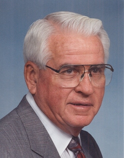


Darrel Maurice “Odie” Oleson
| Birth | : | 20 Aug 1924 Laurens, Pocahontas County, Iowa, USA |
| Death | : | 24 Jan 2015 Mesa, Maricopa County, Arizona, USA |
| Burial | : | Laurens Cemetery, Laurens, Pocahontas County, USA |
| Coordinate | : | 42.8438988, -94.8330994 |
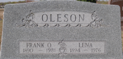
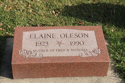
| Description | : | Darrel “Odie” Oleson - age 90, of Laurens, passed away on Saturday, January 24, 2015, in Mesa, Arizona. Darrel Maurice Oleson was born August 20, 1924, in Laurens, Iowa. He was the son of Frank and Lena (Coon) Oleson. He graduated from Laurens High School in 1942 and served in the U.S. Army during WW II. In 1944, Odie married Elaine Spencer in Gilmore City. The couple settled in Laurens where Odie worked for the Laurens Lumber Co. and then for C.I. Hersom Construction Co. He then owned and operated O.K. Roofing Co. in Laurens for many years, retiring in the... Read More |
frequently asked questions (FAQ):
-
Where is Darrel Maurice “Odie” Oleson's memorial?
Darrel Maurice “Odie” Oleson's memorial is located at: Laurens Cemetery, Laurens, Pocahontas County, USA.
-
When did Darrel Maurice “Odie” Oleson death?
Darrel Maurice “Odie” Oleson death on 24 Jan 2015 in Mesa, Maricopa County, Arizona, USA
-
Where are the coordinates of the Darrel Maurice “Odie” Oleson's memorial?
Latitude: 42.8438988
Longitude: -94.8330994
Family Members:
Parent

Spouse
Siblings

Flowers:


Nearby Cemetories:
1. Laurens Cemetery
Laurens, Pocahontas County, USA
Coordinate: 42.8438988, -94.8330994
2. Calvary Cemetery
Laurens, Pocahontas County, USA
Coordinate: 42.8403015, -94.8368988
3. Swan Lake Cemetery
Laurens, Pocahontas County, USA
Coordinate: 42.8511009, -94.8925018
4. Garton Family Cemetery
Marathon, Buena Vista County, USA
Coordinate: 42.8297000, -94.9334500
5. Washington Cemetery
Havelock, Pocahontas County, USA
Coordinate: 42.8363250, -94.7091440
6. Marshall Cemetery
Pocahontas County, USA
Coordinate: 42.7633018, -94.8930969
7. Poland Township Cemetery
Marathon, Buena Vista County, USA
Coordinate: 42.8610992, -94.9916992
8. Fairfield Cemetery
Albert City, Buena Vista County, USA
Coordinate: 42.7783012, -94.9692001
9. Smith Cemetery
Albert City, Buena Vista County, USA
Coordinate: 42.8142014, -94.9925003
10. Rush Lake Cemetery
Rush Lake Township, Palo Alto County, USA
Coordinate: 42.9497185, -94.7383270
11. Garfield Township Cemetery
Webb, Clay County, USA
Coordinate: 42.9538994, -94.9392014
12. Saint Mary's Cemetery
Rush Lake Township, Palo Alto County, USA
Coordinate: 42.9560000, -94.6980000
13. Dover Township Cemetery
Varina, Pocahontas County, USA
Coordinate: 42.6896100, -94.8524200
14. Calvary Cemetery
Pocahontas, Pocahontas County, USA
Coordinate: 42.7335000, -94.6597000
15. Summit Hill Cemetery
Pocahontas, Pocahontas County, USA
Coordinate: 42.7315000, -94.6595000
16. Saint John's Lutheran Cemetery
Albert City, Buena Vista County, USA
Coordinate: 42.7200920, -94.9947630
17. Ellington Cemetery
Ellington Township, Palo Alto County, USA
Coordinate: 42.9377000, -94.6240400
18. Powhatan Cemetery
Plover, Pocahontas County, USA
Coordinate: 42.8557396, -94.5801773
19. Osborn Cemetery
Webb, Clay County, USA
Coordinate: 42.9346918, -95.0608244
20. Silver Lake Cemetery
Silver Lake Township, Palo Alto County, USA
Coordinate: 43.0386009, -94.8597031
21. Calvary Cemetery
Silver Lake Township, Palo Alto County, USA
Coordinate: 43.0386009, -94.8613968
22. Saint Columbkilles Cemetery
Varina, Pocahontas County, USA
Coordinate: 42.6467018, -94.8443985
23. Saint Johns Church Of Christ Cemetery
Storm Lake, Buena Vista County, USA
Coordinate: 42.7108002, -95.0428009
24. Varina Cemetery
Newell Township, Buena Vista County, USA
Coordinate: 42.6539993, -94.9339981