
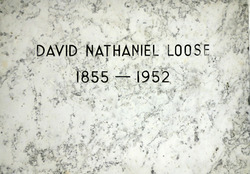
David Nathaniel Loose
| Birth | : | 6 Feb 1855 Lancaster, Lancaster County, Pennsylvania, USA |
| Death | : | 30 Jan 1952 Orlando, Orange County, Florida, USA |
| Burial | : | St. Anne's Churchyard, Chapeltown, Blackburn with Darwen Unitary Authority, England |
| Coordinate | : | 53.6371710, -2.4030440 |
frequently asked questions (FAQ):
-
Where is David Nathaniel Loose's memorial?
David Nathaniel Loose's memorial is located at: St. Anne's Churchyard, Chapeltown, Blackburn with Darwen Unitary Authority, England.
-
When did David Nathaniel Loose death?
David Nathaniel Loose death on 30 Jan 1952 in Orlando, Orange County, Florida, USA
-
Where are the coordinates of the David Nathaniel Loose's memorial?
Latitude: 53.6371710
Longitude: -2.4030440
Family Members:
Spouse

Flowers:


Nearby Cemetories:
1. St. Anne's Churchyard
Chapeltown, Blackburn with Darwen Unitary Authority, England
Coordinate: 53.6371710, -2.4030440
2. Methodist Church Churchyard
Edgworth, Blackburn with Darwen Unitary Authority, England
Coordinate: 53.6424280, -2.3962830
3. Edgworth Congregational Chapelyard
Edgworth, Blackburn with Darwen Unitary Authority, England
Coordinate: 53.6476280, -2.3967210
4. Hawkshaw Methodist Church Cemetery
Hawkshaw, Metropolitan Borough of Bury, England
Coordinate: 53.6313490, -2.3674190
5. St Mary Churchyard
Hawkshaw, Metropolitan Borough of Bury, England
Coordinate: 53.6307270, -2.3636210
6. Christ Church Churchyard
Egerton, Metropolitan Borough of Bolton, England
Coordinate: 53.6237080, -2.4389210
7. Congregational Churchyard
Affetside, Metropolitan Borough of Bury, England
Coordinate: 53.6175200, -2.3705800
8. Tottington Road Methodist Church Churchyard
Harwood, Metropolitan Borough of Bolton, England
Coordinate: 53.6079190, -2.3904960
9. St. Maxentius Churchyard
Bradshaw, Metropolitan Borough of Bolton, England
Coordinate: 53.6056800, -2.4014800
10. Harwood Methodist Church Cemetery
Harwood, Metropolitan Borough of Bolton, England
Coordinate: 53.6028240, -2.3903990
11. Greenmount United Reformed Churchyard
Greenmount, Metropolitan Borough of Bury, England
Coordinate: 53.6254581, -2.3381465
12. St Paul Churchyard
Astley Bridge, Metropolitan Borough of Bolton, England
Coordinate: 53.5996230, -2.4314330
13. St Anne Churchyard
Tottington, Metropolitan Borough of Bury, England
Coordinate: 53.6161499, -2.3409030
14. Bolton Cemetery
Astley Bridge, Metropolitan Borough of Bolton, England
Coordinate: 53.5989150, -2.4370830
15. St. John's Churchyard
Tottington, Metropolitan Borough of Bury, England
Coordinate: 53.6141180, -2.3400670
16. Christ Church Churchyard
Harwood, Metropolitan Borough of Bolton, England
Coordinate: 53.5948860, -2.3821990
17. Emmanuel Churchyard
Holcombe, Metropolitan Borough of Bury, England
Coordinate: 53.6463000, -2.3293400
18. Ramsbottom Cemetery
Ramsbottom, Metropolitan Borough of Bury, England
Coordinate: 53.6372986, -2.3271000
19. St. Paul's Churchyard
Halliwell, Metropolitan Borough of Bolton, England
Coordinate: 53.5955450, -2.4475770
20. Darwen Eastern Cemetery
Darwen, Blackburn with Darwen Unitary Authority, England
Coordinate: 53.6769300, -2.4547700
21. Darwen Cemetery
Darwen, Blackburn with Darwen Unitary Authority, England
Coordinate: 53.6781400, -2.4598300
22. St Peter Churchyard
Belmont, Blackburn with Darwen Unitary Authority, England
Coordinate: 53.6379520, -2.4955480
23. Ainsworth Methodist Churchyard
Ainsworth, Metropolitan Borough of Bury, England
Coordinate: 53.5877390, -2.3623810
24. Belmont Congregational Churchyard
Belmont, Blackburn with Darwen Unitary Authority, England
Coordinate: 53.6419917, -2.4955512