

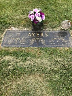
Dawn Marie Wagoner Ayers
| Birth | : | 13 Nov 1941 Pulaski, Pulaski County, Virginia, USA |
| Death | : | 6 Sep 2016 Cana, Carroll County, Virginia, USA |
| Burial | : | Bear Trail Baptist Church Cemetery, Cana, Carroll County, USA |
| Coordinate | : | 36.6263910, -80.6655010 |
| Description | : | Mrs. Dawn Marie Wagoner Ayers, 74, of Cana, VA, passed away Tuesday morning, September 6, 2016, at her home. Mrs. Ayers was born November 13, 1941, in Pulaski, VA, the daughter of the late James and Mary Cruff Wagoner. Dawn formerly owned and operated Ayers Produce in Pulaski, VA, and was a member of Bear Trail Baptist Church. She was a hard worker who was dearly loved by all who knew her. She is survived by her children, Larry Ayers and his fiancée, Tammy Horton, Gary and Lucretia Ayers, Judy and Howard Williams, Michael Ayers and his fiancée, Lisa Thompson,... Read More |
frequently asked questions (FAQ):
-
Where is Dawn Marie Wagoner Ayers's memorial?
Dawn Marie Wagoner Ayers's memorial is located at: Bear Trail Baptist Church Cemetery, Cana, Carroll County, USA.
-
When did Dawn Marie Wagoner Ayers death?
Dawn Marie Wagoner Ayers death on 6 Sep 2016 in Cana, Carroll County, Virginia, USA
-
Where are the coordinates of the Dawn Marie Wagoner Ayers's memorial?
Latitude: 36.6263910
Longitude: -80.6655010
Family Members:
Flowers:


Nearby Cemetories:
1. Bear Trail Baptist Church Cemetery
Cana, Carroll County, USA
Coordinate: 36.6263910, -80.6655010
2. Thomas Cemetery
Fancy Gap, Carroll County, USA
Coordinate: 36.6312940, -80.6592180
3. Leftwich Family Cemetery
Cana, Carroll County, USA
Coordinate: 36.6211110, -80.6758350
4. Rigney Family Cemetery
Cana, Carroll County, USA
Coordinate: 36.6233650, -80.6806990
5. Crooked Oak Moravian Church Cemetery
Cana, Carroll County, USA
Coordinate: 36.6385210, -80.6507840
6. Edwards Cemetery
Cana, Carroll County, USA
Coordinate: 36.6154480, -80.6904890
7. Rocky Ford Christian Church Cemetery
Cana, Carroll County, USA
Coordinate: 36.6080580, -80.6857110
8. Ayers Cemetery
Fancy Gap, Carroll County, USA
Coordinate: 36.6502800, -80.6563873
9. Wash Edwards Cemetery
Fancy Gap, Carroll County, USA
Coordinate: 36.6505890, -80.6777920
10. Tate Cemetery
Fancy Gap, Carroll County, USA
Coordinate: 36.6522590, -80.6835610
11. King Family Cemetery
Cana, Carroll County, USA
Coordinate: 36.6211420, -80.7020900
12. King-Jones Cemetery
Cana, Carroll County, USA
Coordinate: 36.6224890, -80.7033540
13. Pauls Creek Baptist Church Cemetery
Cana, Carroll County, USA
Coordinate: 36.6072870, -80.6976360
14. Wisler Cemetery
Cana, Carroll County, USA
Coordinate: 36.5933240, -80.6756550
15. Elk Spur Cemetery
Fancy Gap, Carroll County, USA
Coordinate: 36.6583610, -80.6808950
16. Oak Grove Baptist Church Cemetery
Cana, Carroll County, USA
Coordinate: 36.6432470, -80.6280060
17. King Cemetery
Cana, Carroll County, USA
Coordinate: 36.6170430, -80.7070900
18. Cana Baptist Church Cemetery
Cana, Carroll County, USA
Coordinate: 36.5920764, -80.6717347
19. Morris Cemetery
Fancy Gap, Carroll County, USA
Coordinate: 36.6460991, -80.7018967
20. Primitive Baptist Church Of Jesus Christ Cemetery
Cana, Carroll County, USA
Coordinate: 36.5917320, -80.6737210
21. Harrold Cemetery
Carroll County, USA
Coordinate: 36.6199300, -80.6219970
22. Mount Bethel Moravian Graveyard
Cana, Carroll County, USA
Coordinate: 36.6053120, -80.6272700
23. Allen Cemetery
Cana, Carroll County, USA
Coordinate: 36.6155280, -80.6192210
24. Fancy Gap Pentecostal Holiness Church Cemetery
Cana, Carroll County, USA
Coordinate: 36.6227090, -80.7150880