
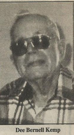
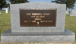

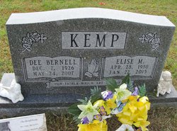
Dee Bernell Kemp
| Birth | : | 7 Dec 1926 New Madrid County, Missouri, USA |
| Death | : | 24 May 2007 East Prairie, Mississippi County, Missouri, USA |
| Burial | : | Dogwood Cemetery, Dogwood, Mississippi County, USA |
| Coordinate | : | 36.8231316, -89.4546738 |
| Description | : | Dee Bernell Kemp, 80, of East Prairie, MO, died at 9:50 a.m. May 24, 2007, at the East Prairie Nursing Center. Born Dec. 7, 1926, in New Madrid County, MO, son of the late John and Lillian Thresher Kemp, he lived all his life in New Madrid and Mississippi counties, where he was a retired farmer and was employed by the St. John's Levee District for more than 20 years. A member of the Full Gospel Church in East Prairie, he was a veteran of the U.S. Army, having served during the Korean War. In 1951, he married Elise Hardin,... Read More |
frequently asked questions (FAQ):
-
Where is Dee Bernell Kemp's memorial?
Dee Bernell Kemp's memorial is located at: Dogwood Cemetery, Dogwood, Mississippi County, USA.
-
When did Dee Bernell Kemp death?
Dee Bernell Kemp death on 24 May 2007 in East Prairie, Mississippi County, Missouri, USA
-
Where are the coordinates of the Dee Bernell Kemp's memorial?
Latitude: 36.8231316
Longitude: -89.4546738
Family Members:
Parent
Spouse
Siblings
Children

Flowers:


Nearby Cemetories:
1. Dogwood Cemetery
Dogwood, Mississippi County, USA
Coordinate: 36.8231316, -89.4546738
2. Armer Cemetery
East Prairie, Mississippi County, USA
Coordinate: 36.8703003, -89.4608002
3. Big Opening Cemetery
New Madrid County, USA
Coordinate: 36.8089500, -89.5247100
4. Memorial Park Cemetery
East Prairie, Mississippi County, USA
Coordinate: 36.7837868, -89.3962479
5. Zilafro Cemetery
East Prairie, Mississippi County, USA
Coordinate: 36.7544960, -89.4100550
6. Greer Family Cemetery
Mississippi County, USA
Coordinate: 36.8017967, -89.3569275
7. Harper Cemetery
Mississippi County, USA
Coordinate: 36.7429200, -89.4150000
8. Pryor Cemetery
Mississippi County, USA
Coordinate: 36.7429680, -89.4147530
9. Bright Prospect Cemetery
Miner, Scott County, USA
Coordinate: 36.8844948, -89.5352707
10. Sikes Family Cemetery
Sikeston, New Madrid County, USA
Coordinate: 36.8410380, -89.5697350
11. Anniston Cemetery
Anniston, Mississippi County, USA
Coordinate: 36.8235100, -89.3336500
12. Bloomfield Cemetery
New Madrid County, USA
Coordinate: 36.7453003, -89.5382996
13. Calvary Cemetery
Charleston, Mississippi County, USA
Coordinate: 36.9212200, -89.3864000
14. Sikeston Memorial Park
Sikeston, New Madrid County, USA
Coordinate: 36.8630981, -89.5867004
15. Oak Grove Cemetery
Charleston, Mississippi County, USA
Coordinate: 36.9227982, -89.3858032
16. Sikeston City Cemetery
Sikeston, Scott County, USA
Coordinate: 36.8696442, -89.5867538
17. Dalton Cemetery
Charleston, Mississippi County, USA
Coordinate: 36.8698880, -89.3194700
18. Hart Cemetery
Miner, Scott County, USA
Coordinate: 36.8986015, -89.5721970
19. Calhoun Cemetery
Mississippi County, USA
Coordinate: 36.7672005, -89.3191986
20. Pulltight Cemetery
Pulltight, Mississippi County, USA
Coordinate: 36.7796300, -89.3108600
21. Matthews Cemetery
Matthews, New Madrid County, USA
Coordinate: 36.7496986, -89.5817032
22. Garden Of Memories Cemetery
Sikeston, Scott County, USA
Coordinate: 36.8650017, -89.6035995
23. Pleasant Valley Cemetery
Sikeston, Scott County, USA
Coordinate: 36.9418983, -89.5132980
24. Hunter Memorial Cemetery
Sikeston, Scott County, USA
Coordinate: 36.8844200, -89.5952800