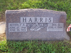
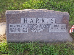
Dee Dae Harris
| Birth | : | 6 Jun 1944 Lexington, Dawson County, Nebraska, USA |
| Death | : | 5 Sep 2011 Lincoln, Lancaster County, Nebraska, USA |
| Burial | : | Rose Hill Cemetery, Callaway, Custer County, USA |
| Coordinate | : | 41.2783012, -99.9203033 |
| Description | : | Dee Dae Harris, 67, of Lincoln, Nebraska, died Monday, September 5, 2011, at BryanLGH Medical Center West in Lincoln. Dee was born June 6, 1944, at Lexington, Nebraska to W.O. and Loretta (Bybee) Harris and was named after the victory, on the same date, in World War II. Dee attended Callaway high school where he met his future wife, Beverly Ann Pitkin. After 4 years in the Navy Dee and Bev married. Dee was employed by Salem Trucking out of Lincoln until he retired several years ago. He enjoyed his long-neck Budweiser's, cigarette smoking, telling jokes and stories; collecting coins, guns and... Read More |
frequently asked questions (FAQ):
-
Where is Dee Dae Harris's memorial?
Dee Dae Harris's memorial is located at: Rose Hill Cemetery, Callaway, Custer County, USA.
-
When did Dee Dae Harris death?
Dee Dae Harris death on 5 Sep 2011 in Lincoln, Lancaster County, Nebraska, USA
-
Where are the coordinates of the Dee Dae Harris's memorial?
Latitude: 41.2783012
Longitude: -99.9203033
Family Members:
Spouse
Flowers:
Nearby Cemetories:
1. Rose Hill Cemetery
Callaway, Custer County, USA
Coordinate: 41.2783012, -99.9203033
2. Kingsbury Cemetery
Callaway, Custer County, USA
Coordinate: 41.3097000, -99.9681015
3. Michaels Cemetery
Callaway, Custer County, USA
Coordinate: 41.2956480, -99.8536800
4. Fairview Cemetery
Callaway, Custer County, USA
Coordinate: 41.3353004, -99.9216995
5. Schreyer Homestead Family Cemetery
Custer County, USA
Coordinate: 41.3330100, -99.9769800
6. Sand Valley Cemetery
Callaway, Custer County, USA
Coordinate: 41.2775002, -100.0242004
7. Lodi Cemetery
Custer County, USA
Coordinate: 41.2196999, -99.8497009
8. Stop Table Cemetery
Custer County, USA
Coordinate: 41.2350006, -100.0642014
9. Riverside Cemetery
Custer County, USA
Coordinate: 41.2447014, -99.7581024
10. Table Lawn Cemetery
Broken Bow, Custer County, USA
Coordinate: 41.3873500, -99.8255500
11. Woldheim Cemetery
Custer County, USA
Coordinate: 41.3852997, -100.0246964
12. Oconto Cemetery
Oconto, Custer County, USA
Coordinate: 41.1477000, -99.7802000
13. Sells Valley Cemetery
Custer County, USA
Coordinate: 41.1624985, -100.0927963
14. Saint Mary Cemetery
Oconto, Custer County, USA
Coordinate: 41.1478004, -99.7639008
15. Tallin Cemetery
Custer County, USA
Coordinate: 41.2625504, -100.1762543
16. Cliff Table Cemetery
Merna, Custer County, USA
Coordinate: 41.4694100, -99.9626800
17. Pleasant Valley Cemetery
Oconto, Custer County, USA
Coordinate: 41.0895000, -99.9890000
18. Christ Lutheran Cemetery
Oconto, Custer County, USA
Coordinate: 41.0759000, -99.8560000
19. Custer Center Cemetery
Broken Bow, Custer County, USA
Coordinate: 41.4377000, -99.7040000
20. Saint Joseph Cemetery
Broken Bow, Custer County, USA
Coordinate: 41.4049988, -99.6647034
21. Kilfoil Cemetery
Merna, Custer County, USA
Coordinate: 41.4883003, -99.7878036
22. Ortello Cemetery
Merna, Custer County, USA
Coordinate: 41.5113983, -99.9024963
23. Powell Canyon Cemetery
Custer County, USA
Coordinate: 41.4543991, -100.1280975
24. Kilmer Valley Cemetery
Lincoln County, USA
Coordinate: 41.3025017, -100.2347031


