

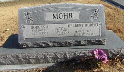
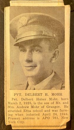
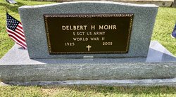
Delbert Hubert Mohr
| Birth | : | 2 Mar 1925 Etna, Scotland County, Missouri, USA |
| Death | : | 22 Jun 2002 Kirksville, Adair County, Missouri, USA |
| Burial | : | Saint Josephs Catholic Church Cemetery, Taneytown, Carroll County, USA |
| Coordinate | : | 39.6579800, -77.1791900 |
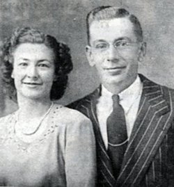
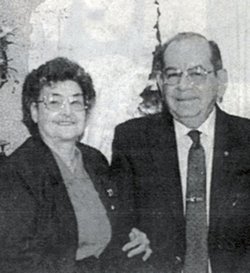
| Description | : | Delbert Hubert Mohr, 77, of Canton, died Saturday, June 22, 2002, at the Northeast Regional Medical Center, in Kirksville. Born March 2, 1925, in Etna, Mo., a son of Andrew W. and Clara (Horn) Mohr. He married the former Dorcas J. Caldwell on December 21, 1947, in Wyaconda. She survives. Mr. Mohr was a member of the First Baptist Church of Canton. He was a farmer before moving to Canton and after moving to Canton worked at Western Augo, the water plant, and the Post Office, before retiring from the Lock and Dam. Survivors... Read More |
frequently asked questions (FAQ):
-
Where is Delbert Hubert Mohr's memorial?
Delbert Hubert Mohr's memorial is located at: Saint Josephs Catholic Church Cemetery, Taneytown, Carroll County, USA.
-
When did Delbert Hubert Mohr death?
Delbert Hubert Mohr death on 22 Jun 2002 in Kirksville, Adair County, Missouri, USA
-
Where are the coordinates of the Delbert Hubert Mohr's memorial?
Latitude: 39.6579800
Longitude: -77.1791900
Family Members:
Parent

Spouse
Siblings


Nearby Cemetories:
1. Saint Josephs Catholic Church Cemetery
Taneytown, Carroll County, USA
Coordinate: 39.6579800, -77.1791900
2. Grace United Church of Christ Cemetery
Taneytown, Carroll County, USA
Coordinate: 39.6610000, -77.1795800
3. Trinity Lutheran Cemetery
Taneytown, Carroll County, USA
Coordinate: 39.6626900, -77.1760600
4. Baptist Road Cemetery
Taneytown, Carroll County, USA
Coordinate: 39.6706900, -77.2023900
5. Mount Pleasant United Methodist Cemetery
Taneytown, Carroll County, USA
Coordinate: 39.6455994, -77.1508026
6. Piney Creek Reformed Presbyterian Church Cemetery
Taneytown, Carroll County, USA
Coordinate: 39.6984500, -77.1977600
7. Piney Creek Church of the Brethren Cemetery
Taneytown, Carroll County, USA
Coordinate: 39.7033005, -77.1536026
8. Sunrise Cemetery
Harney, Carroll County, USA
Coordinate: 39.7125015, -77.2031021
9. Mount Union Lutheran Church Cemetery
Union Bridge, Carroll County, USA
Coordinate: 39.5957985, -77.1772003
10. Mayberry First Church of God Cemetery
Mayberry, Carroll County, USA
Coordinate: 39.6417800, -77.0985300
11. Mountain View Cemetery
Harney, Carroll County, USA
Coordinate: 39.7196500, -77.2098600
12. Keysville Union Cemetery
Keysville, Carroll County, USA
Coordinate: 39.6328500, -77.2590800
13. Lynn Family Cemetery
Middleburg, Carroll County, USA
Coordinate: 39.5924988, -77.2102966
14. Emmanuel Baust Church Cemetery
Westminster, Carroll County, USA
Coordinate: 39.6215400, -77.1002700
15. Middleburg United Methodist Church Cemetery
Middleburg, Carroll County, USA
Coordinate: 39.5938988, -77.2202988
16. Stong Family Cemetery
Union Bridge, Carroll County, USA
Coordinate: 39.5901520, -77.1474440
17. Saint James Reformed Cemetery
Mount Joy Township, Adams County, USA
Coordinate: 39.7312000, -77.1583000
18. Uniontown Church of God Cemetery
Uniontown, Carroll County, USA
Coordinate: 39.5950012, -77.1194000
19. Saint Pauls Lutheran Cemetery
Uniontown, Carroll County, USA
Coordinate: 39.5929222, -77.1208191
20. Mount Joy Cemetery
Carroll County, USA
Coordinate: 39.5922012, -77.1216965
21. Elizabeth Horn Gravesite
Arters Mill, Carroll County, USA
Coordinate: 39.6646700, -77.0717900
22. Uniontown Methodist Cemetery
Uniontown, Carroll County, USA
Coordinate: 39.5940666, -77.1104202
23. Whitmore Family Cemetery
Emmitsburg, Frederick County, USA
Coordinate: 39.6556900, -77.2904200
24. Roop Family Cemetery
Ladiesburg, Frederick County, USA
Coordinate: 39.5730600, -77.2177300