
| Birth | : | 12 Sep 1871 |
| Death | : | 24 Dec 1953 |
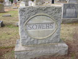
| Burial | : | Hunt Cemetery, West Sonora, Preble County, USA |
| Coordinate | : | 39.9100500, -84.5313400 |
| Plot | : | Row 3 |
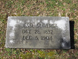
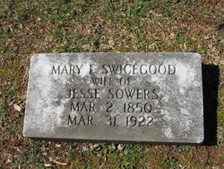
| Description | : | Daughter of Jesse Sowers and Mary Swicegood Sowers Wife of John Walter |
frequently asked questions (FAQ):
-
Where is Delia Amanda Sowers Myers's memorial?
Delia Amanda Sowers Myers's memorial is located at: Hunt Cemetery, West Sonora, Preble County, USA.
-
When did Delia Amanda Sowers Myers death?
Delia Amanda Sowers Myers death on 24 Dec 1953 in
-
Where are the coordinates of the Delia Amanda Sowers Myers's memorial?
Latitude: 39.9100500
Longitude: -84.5313400
Family Members:
Parent
Spouse

Siblings
Children
Flowers:


Nearby Cemetories:
1. Hunt Cemetery
West Sonora, Preble County, USA
Coordinate: 39.9100500, -84.5313400
2. Gordon Cemetery
Gordon, Darke County, USA
Coordinate: 39.9283840, -84.5063390
3. Ithaca Lutheran Cemetery
Ithaca, Darke County, USA
Coordinate: 39.9357490, -84.5517200
4. Verona Cemetery
Verona, Preble County, USA
Coordinate: 39.8958015, -84.4961014
5. Ithaca Cemetery
Ithaca, Darke County, USA
Coordinate: 39.9431000, -84.5597000
6. Brown Cemetery
West Manchester, Preble County, USA
Coordinate: 39.8950005, -84.5958328
7. Roselawn Cemetery
Lewisburg, Preble County, USA
Coordinate: 39.8518982, -84.5428009
8. Lower Lewisburg Cemetery
Lewisburg, Preble County, USA
Coordinate: 39.8453331, -84.5369339
9. Dry Fork Cemetery
West Manchester, Preble County, USA
Coordinate: 39.8795433, -84.6157150
10. Castine Cemetery
Castine, Darke County, USA
Coordinate: 39.9306050, -84.6210650
11. Railroad Cemetery
Castine, Darke County, USA
Coordinate: 39.9183410, -84.6244710
12. Bachman Cemetery
Bachman, Montgomery County, USA
Coordinate: 39.8613620, -84.4602300
13. Old Castine Cemetery
Castine, Darke County, USA
Coordinate: 39.9383011, -84.6250000
14. Saint Johns Evangelical Lutheran Cemetery
Lewisburg, Preble County, USA
Coordinate: 39.8385620, -84.4880680
15. Parish Cemetery
Arlington, Montgomery County, USA
Coordinate: 39.8660660, -84.4297028
16. Arlington Cemetery
Brookville, Montgomery County, USA
Coordinate: 39.8652992, -84.4297028
17. Arnett Cemetery
Miami County, USA
Coordinate: 39.9546220, -84.4172500
18. Monroe Cemetery
Eldorado, Preble County, USA
Coordinate: 39.8878710, -84.6562140
19. Phillipsburg Christian Cemetery
Phillipsburg, Montgomery County, USA
Coordinate: 39.9068240, -84.4026870
20. Wares Chapel Cemetery
West Manchester, Preble County, USA
Coordinate: 39.8644447, -84.6466675
21. Mote Cemetery
Pitsburg, Darke County, USA
Coordinate: 39.9916801, -84.4562836
22. Pleasant View Church Cemetery
Eldorado, Preble County, USA
Coordinate: 39.8860700, -84.6611710
23. Phillipsburg Cemetery
Phillipsburg, Montgomery County, USA
Coordinate: 39.9124985, -84.3974991
24. Old South Fork Friends Cemetery
Phillipsburg, Montgomery County, USA
Coordinate: 39.9043330, -84.3971670