
| Birth | : | 21 Feb 1878 Muscatine County, Iowa, USA |
| Death | : | 15 Aug 1966 Fremont, Dodge County, Nebraska, USA |
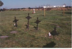
| Burial | : | Ridge Cemetery, Fremont, Dodge County, USA |
| Coordinate | : | 41.4425011, -96.5231018 |
| Plot | : | South Half |
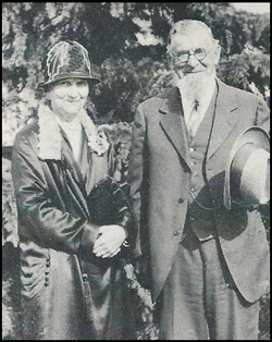
| Description | : | Private services for Mrs. Frank Gardner, 88, Dodge County Community Hospital Annex, will be at 10 a.m. tomorrow at Lattin-Dugan-Chambers Chapel, with Rev. Frederick Muller officiating. Mrs. Gardner died yesterday at Dodge County Hospital. She was born Feb. 21, 1878, in Muscatine, Iowa. She has lived in this community about 80 years. She was married to George Petersen who died in 1903. She married Frank Gardner Sept. 11,1912. He died Nov. 14, 1964. She was a member of the Methodist Church and the Eastern Star. Survivors are a son Victor Petersen, and a sister, Sarah E.... Read More |
frequently asked questions (FAQ):
-
Where is Della B Brenner Peterson Gardner's memorial?
Della B Brenner Peterson Gardner's memorial is located at: Ridge Cemetery, Fremont, Dodge County, USA.
-
When did Della B Brenner Peterson Gardner death?
Della B Brenner Peterson Gardner death on 15 Aug 1966 in Fremont, Dodge County, Nebraska, USA
-
Where are the coordinates of the Della B Brenner Peterson Gardner's memorial?
Latitude: 41.4425011
Longitude: -96.5231018
Family Members:
Parent

Spouse
Siblings
Flowers:


Nearby Cemetories:
1. Ridge Cemetery
Fremont, Dodge County, USA
Coordinate: 41.4425011, -96.5231018
2. Calvary Cemetery
Fremont, Dodge County, USA
Coordinate: 41.4435997, -96.5271988
3. Memorial Cemetery
Fremont, Dodge County, USA
Coordinate: 41.4516210, -96.5058210
4. First Congregational Church Columbarium
Fremont, Dodge County, USA
Coordinate: 41.4439000, -96.4974300
5. Saint James Episcopal Church Columbarium
Fremont, Dodge County, USA
Coordinate: 41.4334370, -96.4944130
6. Critten Barrett Cemetery
Cedar Bluffs, Saunders County, USA
Coordinate: 41.4229110, -96.5577650
7. Maple Grove Cemetery
Cedar Bluffs, Saunders County, USA
Coordinate: 41.3880997, -96.6006012
8. Bluffs Trinity Lutheran Cemetery
Fremont, Dodge County, USA
Coordinate: 41.5098080, -96.5973720
9. Platteville Cemetery
Saunders County, USA
Coordinate: 41.3506012, -96.5410995
10. Wiegand Cemetery
Cedar Bluffs, Saunders County, USA
Coordinate: 41.3819008, -96.6205978
11. Pohocco Lutheran Church Cemetery
Leshara, Saunders County, USA
Coordinate: 41.3462715, -96.5026627
12. Hartung Cemetery
Washington County, USA
Coordinate: 41.5182991, -96.4257965
13. Johannes Cemetery
Cedar Bluffs, Saunders County, USA
Coordinate: 41.3788986, -96.6438980
14. Maple Creek Christian Cemetery
Fremont, Dodge County, USA
Coordinate: 41.5390200, -96.5973600
15. Little Flower Cemetery
Pohocco Township, Saunders County, USA
Coordinate: 41.3350860, -96.4834470
16. Union Cemetery
Cedar Bluffs, Saunders County, USA
Coordinate: 41.3513985, -96.6108017
17. Fontanelle Lutheran Cemetery
Fontanelle, Washington County, USA
Coordinate: 41.5384827, -96.4214783
18. Gods Acre Cemetery
Arlington, Washington County, USA
Coordinate: 41.5060997, -96.3677979
19. Bethel Methodist Cemetery
Dodge County, USA
Coordinate: 41.5583687, -96.6172409
20. Saint Marys Cemetery
Saunders County, USA
Coordinate: 41.3932991, -96.6943970
21. Arlington Cemetery
Arlington, Washington County, USA
Coordinate: 41.4597015, -96.3392029
22. Valley Cemetery
Valley, Douglas County, USA
Coordinate: 41.3446999, -96.3794022
23. Green Mound Cemetery
Saunders County, USA
Coordinate: 41.2855988, -96.5250015
24. Colby-Morley Cemetery
Arlington, Washington County, USA
Coordinate: 41.4664050, -96.3126470