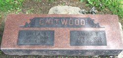
Della Belinda Tyree Chitwood
| Birth | : | 10 Aug 1882 Montrose, Henry County, Missouri, USA |
| Death | : | 5 Jan 1961 Carthage, Jasper County, Missouri, USA |
| Burial | : | Appleton City Cemetery, Appleton City, St. Clair County, USA |
| Coordinate | : | 38.1747017, -94.0235977 |
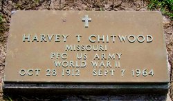
| Description | : | Della was the daughter of James H. Tyree and Katherine Massey. On August 16, 1902 in St. Clair Co., she married James Thomas Chitwood. (Della was previously married to an Unknown Capps or Copps. No record of possible Capps/Copps children.) James Chitwood and Della Tyree had three known children: Constance V. (c1904 AR), Marie E. (c1907 MO), and Harvey T. (1912 MO). |
frequently asked questions (FAQ):
-
Where is Della Belinda Tyree Chitwood's memorial?
Della Belinda Tyree Chitwood's memorial is located at: Appleton City Cemetery, Appleton City, St. Clair County, USA.
-
When did Della Belinda Tyree Chitwood death?
Della Belinda Tyree Chitwood death on 5 Jan 1961 in Carthage, Jasper County, Missouri, USA
-
Where are the coordinates of the Della Belinda Tyree Chitwood's memorial?
Latitude: 38.1747017
Longitude: -94.0235977
Family Members:
Parent
Spouse
Siblings
Children
Flowers:
Nearby Cemetories:
1. Appleton City Cemetery
Appleton City, St. Clair County, USA
Coordinate: 38.1747017, -94.0235977
2. Fennewald Cemetery
Appleton City, St. Clair County, USA
Coordinate: 38.2080994, -94.0271988
3. Spring Grove Cemetery
St. Clair County, USA
Coordinate: 38.1250000, -94.0066986
4. Ridgeway Cemetery
St. Clair County, USA
Coordinate: 38.1114006, -93.9931030
5. Meyers Cemetery
Rockville, Bates County, USA
Coordinate: 38.1193650, -94.0815930
6. Montrose Mound Cemetery
Montrose, Henry County, USA
Coordinate: 38.2406150, -93.9805380
7. Blackwell Cemetery
Bates County, USA
Coordinate: 38.1810989, -94.1183014
8. Montrose Cemetery
Montrose, Henry County, USA
Coordinate: 38.2569008, -94.0038986
9. Round Prairie Cemetery
Bates County, USA
Coordinate: 38.1380997, -94.1247025
10. Daller Cemetery
St. Clair County, USA
Coordinate: 38.0988998, -93.9664001
11. Snodgrass Union Cemetery
Bates County, USA
Coordinate: 38.2583008, -94.0761032
12. Ditty Cemetery
St. Clair County, USA
Coordinate: 38.0908012, -93.9664001
13. Saint Mary's Cemetery
Montrose, Henry County, USA
Coordinate: 38.2705320, -93.9932730
14. Myers Cemetery
Hudson, Bates County, USA
Coordinate: 38.2050018, -94.1519012
15. Bean Cemetery
Appleton City, St. Clair County, USA
Coordinate: 38.0960999, -93.9325027
16. Dickison Cemetery
Bates County, USA
Coordinate: 38.2641300, -94.1032650
17. Short Cemetery
St. Clair County, USA
Coordinate: 38.0797005, -93.9464035
18. Rockville Cemetery
Rockville, Bates County, USA
Coordinate: 38.0647011, -94.0663986
19. Harmony Church Cemetery
St. Clair County, USA
Coordinate: 38.1249199, -93.8898163
20. Saint Ludger's Cemetery
Germantown, Henry County, USA
Coordinate: 38.2930450, -94.0252380
21. Westfield Cemetery
St. Clair County, USA
Coordinate: 38.1707993, -93.8677979
22. Teays Chapel Cemetery
Deepwater, Henry County, USA
Coordinate: 38.2188200, -93.8753280
23. Dewees Cemetery
Pleasant Gap, Bates County, USA
Coordinate: 38.1803770, -94.1858160
24. Vickers Cemetery
Montrose, Henry County, USA
Coordinate: 38.2921982, -93.9518967


