

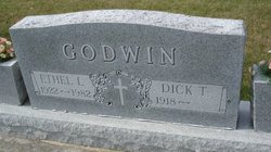
Dick Thomas Godwin
| Birth | : | 30 Apr 1918 Montana, USA |
| Death | : | 16 Jan 2010 Panora, Guthrie County, Iowa, USA |
| Burial | : | St. Mary the Virgin Churchyard, Prescot, Metropolitan Borough of Knowsley, England |
| Coordinate | : | 53.4284600, -2.8067000 |
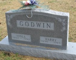
| Description | : | Dick T. Godwin, 91, son of Harry & Viola (Dickey) Godwin, was born April 30,1918 in Montana. He passed away Saturday, January 16, 2010 at the Panora Nursing and Rehab Center. He attended Panora schools. He married Ethel Ermeling and to this union seven children were born. They made their home in various communities in and around Guthrie County. Dick worked as a farmer and an auctioneer. Dick retired from farming in 1981. Ethel passed away in 1982. On January 28, 1986, Dick married Donna White. They made their home in Yale, Iowa. He retired from auctioneering in 2000. He enjoyed antiques,... Read More |
frequently asked questions (FAQ):
-
Where is Dick Thomas Godwin's memorial?
Dick Thomas Godwin's memorial is located at: St. Mary the Virgin Churchyard, Prescot, Metropolitan Borough of Knowsley, England.
-
When did Dick Thomas Godwin death?
Dick Thomas Godwin death on 16 Jan 2010 in Panora, Guthrie County, Iowa, USA
-
Where are the coordinates of the Dick Thomas Godwin's memorial?
Latitude: 53.4284600
Longitude: -2.8067000
Family Members:
Parent

Spouse
Siblings

Children

Flowers:


Nearby Cemetories:
1. St. Mary the Virgin Churchyard
Prescot, Metropolitan Borough of Knowsley, England
Coordinate: 53.4284600, -2.8067000
2. Prescot Cemetery
Prescot, Metropolitan Borough of Knowsley, England
Coordinate: 53.4266620, -2.8081590
3. St. Nicholas' Churchyard
Whiston, Metropolitan Borough of Knowsley, England
Coordinate: 53.4069736, -2.8028920
4. Knowsley Cemetery
Knowsley, Metropolitan Borough of Knowsley, England
Coordinate: 53.4083240, -2.7847870
5. St. Michael Churchyard
Huyton with Roby, Metropolitan Borough of Knowsley, England
Coordinate: 53.4139560, -2.8396720
6. St. Agnes Roman Catholic
Huyton with Roby, Metropolitan Borough of Knowsley, England
Coordinate: 53.4090600, -2.8320100
7. St Michael Churchyard Extension
Huyton with Roby, Metropolitan Borough of Knowsley, England
Coordinate: 53.4143310, -2.8418050
8. St Ann’s Graveyard
Rainhill, Metropolitan Borough of St Helens, England
Coordinate: 53.4157487, -2.7638276
9. Christ Church Churchyard
Eccleston, Metropolitan Borough of St Helens, England
Coordinate: 53.4542560, -2.7778900
10. St. Bartholomew's Churchyard
Huyton with Roby, Metropolitan Borough of Knowsley, England
Coordinate: 53.4120023, -2.8556125
11. St Bartholomew's Churchyard
Rainhill, Metropolitan Borough of St Helens, England
Coordinate: 53.4076231, -2.7513287
12. St. Mary's Churchyard
Knowsley, Metropolitan Borough of Knowsley, England
Coordinate: 53.4561960, -2.8528580
13. GreenAcres Cemetery
Rainford, Metropolitan Borough of St Helens, England
Coordinate: 53.4713530, -2.8064280
14. Yew Tree Roman Catholic Cemetery
West Derby, Metropolitan Borough of Liverpool, England
Coordinate: 53.4285700, -2.8790700
15. St. Helen's Cemetery and Crematorium
St Helens, Metropolitan Borough of St Helens, England
Coordinate: 53.4678993, -2.7607000
16. Windleshaw Chantry
St Helens, Metropolitan Borough of St Helens, England
Coordinate: 53.4672417, -2.7550773
17. Friends Meeting House, Hardshaw, St Helens
St Helens, Metropolitan Borough of St Helens, England
Coordinate: 53.4518340, -2.7320414
18. St Nicholas Churchyard
St Helens, Metropolitan Borough of St Helens, England
Coordinate: 53.4284660, -2.7213830
19. St. John the Evangelist Churchyard
Knotty Ash, Metropolitan Borough of Liverpool, England
Coordinate: 53.4160757, -2.8913708
20. All Saints Churchyard
Childwall, Metropolitan Borough of Liverpool, England
Coordinate: 53.3952880, -2.8816030
21. Broadgreen Jewish Cemetery
Liverpool, Metropolitan Borough of Liverpool, England
Coordinate: 53.4101320, -2.8977320
22. St. Anne and Blessed Dominic Churchyard
St Helens, Metropolitan Borough of St Helens, England
Coordinate: 53.4330960, -2.7083700
23. St. Nicholas Churchyard
Halewood, Metropolitan Borough of Knowsley, England
Coordinate: 53.3694400, -2.8284900
24. St Swithins Churchyard
Liverpool, Metropolitan Borough of Liverpool, England
Coordinate: 53.4585631, -2.9012280