
| Birth | : | 26 May 1872 Minonk, Woodford County, Illinois, USA |
| Death | : | 2 Feb 1945 Clay County, Nebraska, USA |
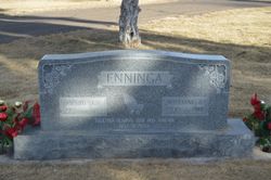
| Burial | : | Saint Pauls Lutheran Cemetery, Adams County, USA |
| Coordinate | : | 40.5104530, -98.2872960 |
| Plot | : | Record # 100, Section A, Block 4, Lot 2, Grave 1 |
frequently asked questions (FAQ):
-
Where is Dirk H “Dick” Enninga's memorial?
Dirk H “Dick” Enninga's memorial is located at: Saint Pauls Lutheran Cemetery, Adams County, USA.
-
When did Dirk H “Dick” Enninga death?
Dirk H “Dick” Enninga death on 2 Feb 1945 in Clay County, Nebraska, USA
-
Where are the coordinates of the Dirk H “Dick” Enninga's memorial?
Latitude: 40.5104530
Longitude: -98.2872960
Family Members:
Parent

Spouse
Siblings
Children
Flowers:


Nearby Cemetories:
1. Saint Pauls Lutheran Cemetery
Adams County, USA
Coordinate: 40.5104530, -98.2872960
2. Glenvil Cemetery
Glenvil, Clay County, USA
Coordinate: 40.5088400, -98.2604700
3. True Dutch Reformed Cemetery
Pauline, Adams County, USA
Coordinate: 40.4801300, -98.3160600
4. Scandinavian Lutheran Cemetery
Pauline, Adams County, USA
Coordinate: 40.4800700, -98.3162900
5. Hanover Presbyterian Church Cemetery
Adams County, USA
Coordinate: 40.4802900, -98.3353850
6. Fleming Farm Pet Cemetery
Hastings, Adams County, USA
Coordinate: 40.5547500, -98.3156100
7. Glenville Union Cemetery
Glenvil, Clay County, USA
Coordinate: 40.5308980, -98.2052220
8. South Inland Cemetery
Clay County, USA
Coordinate: 40.5682900, -98.2217500
9. Old Inland Cemetery
Hastings, Adams County, USA
Coordinate: 40.5872300, -98.2974500
10. Anandale Cemetery
Glenvil, Clay County, USA
Coordinate: 40.4661900, -98.1935300
11. Inland Cemetery
Clay County, USA
Coordinate: 40.5964012, -98.2581024
12. Kingston Cemetery
Adams County, USA
Coordinate: 40.4383250, -98.3695220
13. Zion Cemetery
Clay County, USA
Coordinate: 40.5382996, -98.1643982
14. Mount Sinai Cemetery
Hastings, Adams County, USA
Coordinate: 40.5978012, -98.3647003
15. Blue Valley Cemetery
Ayr, Adams County, USA
Coordinate: 40.4488983, -98.4011002
16. Parkview Cemetery
Hastings, Adams County, USA
Coordinate: 40.5985985, -98.3677979
17. Spring Ranch Cemetery
Clay County, USA
Coordinate: 40.4065100, -98.2484100
18. Saint Marks Episcopal Chapel Columbarium
Hastings, Adams County, USA
Coordinate: 40.5877800, -98.3922100
19. First Presbyterian Columbarium
Hastings, Adams County, USA
Coordinate: 40.5895900, -98.3913100
20. Crosier Monastery Cemetery
Hastings, Adams County, USA
Coordinate: 40.6014740, -98.3787920
21. Highland Cemetery
Hastings, Adams County, USA
Coordinate: 40.5983009, -98.3906021
22. Grace Methodist Church Memorial Columbarium
Hastings, Adams County, USA
Coordinate: 40.5937480, -98.4082340
23. Immanuel Lutheran Church Cemetery
Ayr, Adams County, USA
Coordinate: 40.5247870, -98.4583300
24. Ingleside Cemetery
Adams County, USA
Coordinate: 40.5862340, -98.4464990