
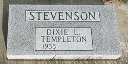
Dixie Lee Templeton Stevenson
| Birth | : | 29 Dec 1933 Etterville, Miller County, Missouri, USA |
| Death | : | 14 Aug 2015 Kennewick, Benton County, Washington, USA |
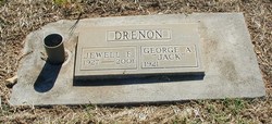
| Burial | : | Los Molinos Cemetery, Los Molinos, Tehama County, USA |
| Coordinate | : | 40.0475650, -122.1011820 |
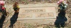
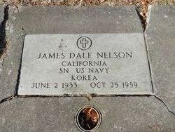
| Description | : | JMA# R455141 When Dixie was a very young child, her family relocated to Red Bluff, California where her father worked on the Shasta Dam and at orchards at that place. Dixie was the daughter of Arley William Tempelton and Nina Farley Tempelton. They bought a ranch at Los Molinas, California and Dixie graduated from the high school at that place. She then went to work for an insurance agency at Red Bluff. Dixie married first to James Nelson on 21 January 1956 at Red Bluff. They made their home at that place but soon relocated to Redding, California where, her husband... Read More |
frequently asked questions (FAQ):
-
Where is Dixie Lee Templeton Stevenson's memorial?
Dixie Lee Templeton Stevenson's memorial is located at: Los Molinos Cemetery, Los Molinos, Tehama County, USA.
-
When did Dixie Lee Templeton Stevenson death?
Dixie Lee Templeton Stevenson death on 14 Aug 2015 in Kennewick, Benton County, Washington, USA
-
Where are the coordinates of the Dixie Lee Templeton Stevenson's memorial?
Latitude: 40.0475650
Longitude: -122.1011820
Family Members:
Parent

Spouse
Siblings
Flowers:


Nearby Cemetories:
1. Los Molinos Cemetery
Los Molinos, Tehama County, USA
Coordinate: 40.0475650, -122.1011820
2. Tehama Cemetery
Tehama, Tehama County, USA
Coordinate: 40.0233002, -122.1433029
3. Growney Ranch Family Cemetery
Red Bluff, Tehama County, USA
Coordinate: 40.1167300, -122.1952500
4. New Clairvaux Abbey Cemetery
Vina, Tehama County, USA
Coordinate: 39.9381450, -122.0641890
5. Vina Cemetery
Vina, Tehama County, USA
Coordinate: 39.9636440, -121.9957070
6. Sunset Hill Cemetery
Corning, Tehama County, USA
Coordinate: 39.9271600, -122.1586100
7. Oak Hill Cemetery
Red Bluff, Tehama County, USA
Coordinate: 40.1699982, -122.2433014
8. Red Bluff Memorial Chapel Mausoleum & Columbarium
Red Bluff, Tehama County, USA
Coordinate: 40.1717130, -122.2466860
9. Saint Mary's Cemetery
Red Bluff, Tehama County, USA
Coordinate: 40.1716995, -122.2521973
10. Kirkwood Cemetery
Corning, Tehama County, USA
Coordinate: 39.8624992, -122.1519012
11. Pine Creek Cemetery
Chico, Butte County, USA
Coordinate: 39.8617240, -121.9842480
12. Red Bank Cemetery
Red Bank, Tehama County, USA
Coordinate: 40.1036970, -122.4458540
13. Cameron-Davis Cemetery
Tehama County, USA
Coordinate: 40.2709800, -121.8778500
14. Orland Masonic Cemetery
Orland, Glenn County, USA
Coordinate: 39.7684760, -122.1943310
15. Elmore Cemetery
Flournoy, Tehama County, USA
Coordinate: 39.8642006, -122.4005966
16. Bragg Cemetery
Nord, Butte County, USA
Coordinate: 39.7750980, -121.9568170
17. Inks Creek Cemetery
Tehama County, USA
Coordinate: 40.3419800, -122.1297100
18. Graves Cemetery
Orland, Glenn County, USA
Coordinate: 39.7827988, -122.2930984
19. Cohasset Cemetery
Cohasset, Butte County, USA
Coordinate: 39.9124880, -121.7333220
20. Benner Family Cemetery
Tehama County, USA
Coordinate: 40.1826890, -121.7183500
21. Cottonwood Creek Ranch Cemetery
Cottonwood, Shasta County, USA
Coordinate: 40.3663100, -122.2598800
22. Paskenta Cemetery
Corning, Tehama County, USA
Coordinate: 39.9002991, -122.5089035
23. Orland Catholic Cemetery
Orland, Glenn County, USA
Coordinate: 39.7030983, -122.1393967
24. Orland IOOF Cemetery
Orland, Glenn County, USA
Coordinate: 39.7026000, -122.1401000