


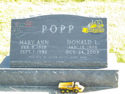
Donald Lee Popp
| Birth | : | 18 Jan 1938 Mitchell County, Iowa, USA |
| Death | : | 24 Oct 2009 Osage, Mitchell County, Iowa, USA |
| Burial | : | Sacred Heart Cemetery, Osage, Mitchell County, USA |
| Coordinate | : | 43.2742004, -92.7917023 |
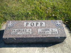
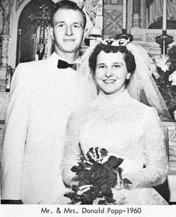
| Description | : | OSAGE - Donald Lee Popp, age 71, of Osage, passed away unexpectedly at his home Saturday (Oct. 24, 2009). Mass of Christian burial will be held at 10 a.m. Tuesday, Oct. 27, 2009, at the Sacred Heart Catholic Church in Osage with the Rev. John Moser officiating. Burial will be in the Sacred Heart Cemetery.Visitation is from 4 to 8 p.m. today at the Champion-Bucheit Funeral Home in Osage where there will be a scripture service at 8 p.m.Don was born Jan. 18, 1938, in Mitchell County, the son of John and Frances (Falk) Popp. He attended Rock No. 1... Read More |
frequently asked questions (FAQ):
-
Where is Donald Lee Popp's memorial?
Donald Lee Popp's memorial is located at: Sacred Heart Cemetery, Osage, Mitchell County, USA.
-
When did Donald Lee Popp death?
Donald Lee Popp death on 24 Oct 2009 in Osage, Mitchell County, Iowa, USA
-
Where are the coordinates of the Donald Lee Popp's memorial?
Latitude: 43.2742004
Longitude: -92.7917023
Family Members:
Parent

Spouse
Siblings

Flowers:


Nearby Cemetories:
1. Sacred Heart Cemetery
Osage, Mitchell County, USA
Coordinate: 43.2742004, -92.7917023
2. South Osage Mennonite Church Cemetery
Osage, Mitchell County, USA
Coordinate: 43.2544556, -92.7915573
3. Osage Cemetery
Osage, Mitchell County, USA
Coordinate: 43.2916700, -92.8201700
4. Tucker Cemetery
Osage, Mitchell County, USA
Coordinate: 43.2494011, -92.8319016
5. Orchard Cemetery
Orchard, Mitchell County, USA
Coordinate: 43.2249985, -92.7838898
6. Calvary Cemetery
Osage, Mitchell County, USA
Coordinate: 43.2238998, -92.8300018
7. Oak Grove Cemetery
Mitchell, Mitchell County, USA
Coordinate: 43.3156013, -92.8707962
8. Dudley Cemetery
Dudley (historical), Mitchell County, USA
Coordinate: 43.2252998, -92.8743973
9. Rock Creek Cemetery
Meroa, Mitchell County, USA
Coordinate: 43.2352791, -92.9225006
10. Stillwater Cemetery
Orchard, Mitchell County, USA
Coordinate: 43.2130585, -92.6780624
11. Eden Presbyterian Cemetery
Meroa, Mitchell County, USA
Coordinate: 43.2131004, -92.9103012
12. Beaver Creek Cemetery
Brownville, Mitchell County, USA
Coordinate: 43.3397217, -92.6727829
13. Saint Peters Cemetery
New Haven, Mitchell County, USA
Coordinate: 43.2858315, -92.6427765
14. Howardville Cemetery
Floyd, Floyd County, USA
Coordinate: 43.1866989, -92.7016983
15. West End Cemetery
Meroa, Mitchell County, USA
Coordinate: 43.2216682, -92.9250031
16. Riverview Cemetery
Saint Ansgar, Mitchell County, USA
Coordinate: 43.3430328, -92.9220200
17. Liberty Cemetery
Little Cedar, Mitchell County, USA
Coordinate: 43.3856010, -92.7230988
18. Saint Ansgar Cemetery
Saint Ansgar, Mitchell County, USA
Coordinate: 43.3777809, -92.9094391
19. Immanuel Lutheran Cemetery
Saint Ansgar, Mitchell County, USA
Coordinate: 43.3717003, -92.9257965
20. First Lutheran Cemetery
Saint Ansgar, Mitchell County, USA
Coordinate: 43.3841705, -92.9194412
21. Blakestad Cemetery
Saint Ansgar, Mitchell County, USA
Coordinate: 43.3711014, -92.9400024
22. Saint Johns Lutheran Cemetery
Rock Creek, Mitchell County, USA
Coordinate: 43.3295560, -92.9849770
23. Saint Johns Lutheran Old Cemetery
Rock Creek, Mitchell County, USA
Coordinate: 43.3313904, -92.9897232
24. Stacyville Cemetery
Stacyville, Mitchell County, USA
Coordinate: 43.4294014, -92.7908020