Donald LeRoy Sederdahl
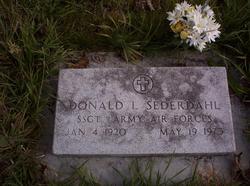
| Birth | : | 4 Jan 1920 Hettinger, Adams County, North Dakota, USA |
| Death | : | 19 May 1973 Helena, Lewis and Clark County, Montana, USA |
| Burial | : | Highland Cemetery, Cameron, Marshall County, USA |
| Coordinate | : | 39.8403015, -80.5594025 |
| Plot | : | Blk 03- Lot 12- Div D-1 |
frequently asked questions (FAQ):
-
Where is Donald LeRoy Sederdahl's memorial?
Donald LeRoy Sederdahl's memorial is located at: Highland Cemetery, Cameron, Marshall County, USA.
-
When did Donald LeRoy Sederdahl death?
Donald LeRoy Sederdahl death on 19 May 1973 in Helena, Lewis and Clark County, Montana, USA
-
Where are the coordinates of the Donald LeRoy Sederdahl's memorial?
Latitude: 39.8403015
Longitude: -80.5594025
Family Members:
Parent
Spouse
Siblings
Flowers:
Nearby Cemetories:
1. Highland Cemetery
Cameron, Marshall County, USA
Coordinate: 39.8403015, -80.5594025
2. Clouston Cemetery
Clouston, Marshall County, USA
Coordinate: 39.8478012, -80.5567017
3. Howard Cemetery
Cameron, Marshall County, USA
Coordinate: 39.8311005, -80.5505981
4. Strope Cemetery
Cameron, Marshall County, USA
Coordinate: 39.8283005, -80.5531006
5. Cameron Cemetery
Cameron, Marshall County, USA
Coordinate: 39.8272018, -80.5733032
6. Fletcher-Earliwine Cemetery
Marshall County, USA
Coordinate: 39.8666992, -80.5381012
7. Bane Cemetery
Marshall County, USA
Coordinate: 39.8731003, -80.5639038
8. Rock Lick Cemetery
Marshall County, USA
Coordinate: 39.8699989, -80.5318985
9. Fork Ridge Baptist Cemetery
Glen Easton, Marshall County, USA
Coordinate: 39.8717003, -80.5907974
10. Hubbs Cemetery
Marshall County, USA
Coordinate: 39.8502998, -80.6093979
11. Big Run Cemetery
Big Run, Marshall County, USA
Coordinate: 39.7991982, -80.5563965
12. Slonaker Cemetery
Aleppo Township, Greene County, USA
Coordinate: 39.8238983, -80.5074997
13. Beeler Station Cemetery
Moundsville, Marshall County, USA
Coordinate: 39.8838997, -80.5911026
14. Hewitt Cemetery
McCracken, Greene County, USA
Coordinate: 39.8521500, -80.4949400
15. Wise Cemetery
Quiet Dell, Greene County, USA
Coordinate: 39.7992700, -80.5101400
16. Fork Ridge Cemetery
Moundsville, Marshall County, USA
Coordinate: 39.8675003, -80.6331024
17. Tedrow Cemetery
Aleppo Township, Greene County, USA
Coordinate: 39.8002000, -80.4921000
18. Sugar Grove Cemetery
McCracken, Greene County, USA
Coordinate: 39.8542000, -80.4750000
19. Easton Cemetery
Glen Easton, Marshall County, USA
Coordinate: 39.8354250, -80.6470380
20. Fork Ridge Christian Cemetery
Marshall County, USA
Coordinate: 39.8686690, -80.6405370
21. Fork Ridge Universalist Cemetery
Glen Easton, Marshall County, USA
Coordinate: 39.8689003, -80.6408005
22. Brushy Ridge Cemetery
Marshall County, USA
Coordinate: 39.8602982, -80.6472015
23. Bryan Home Cemetery
Bryan, Greene County, USA
Coordinate: 39.8752400, -80.4788300
24. Bosworth-Strope Cemetery
Aleppo Township, Greene County, USA
Coordinate: 39.7973130, -80.4794250

