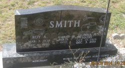
Donna Mae Squire Smith
| Birth | : | 15 Oct 1926 Indianola, Warren County, Iowa, USA |
| Death | : | 3 Dec 2011 Chadron, Dawes County, Nebraska, USA |
| Burial | : | White Clay Cemetery, Rushville, Sheridan County, USA |
| Coordinate | : | 42.9732820, -102.5667230 |
| Description | : | Donna Mae (Squire) Smith, 85, died Saturday, December 3, 2011 at her home in Chadron, NE. Donna was born October 15, 1926 in Indianola, Iowa to Donald R. and Bessie L (Merriam) Squire. Donna received her nursing education though the Cadet Nursing Corps from 1945 to 1948 at the Iowa Lutheran Hospital School of Nursing. On April 5, 1950 she was united in marriage to Roy A. Smith. Donna worked as a Registered Nurse at the U.S. Indian Health Services in Pine Ridge, SD from 1947 to 1950 and then again from 1976 to 2003. She lived in White Clay... Read More |
frequently asked questions (FAQ):
-
Where is Donna Mae Squire Smith's memorial?
Donna Mae Squire Smith's memorial is located at: White Clay Cemetery, Rushville, Sheridan County, USA.
-
When did Donna Mae Squire Smith death?
Donna Mae Squire Smith death on 3 Dec 2011 in Chadron, Dawes County, Nebraska, USA
-
Where are the coordinates of the Donna Mae Squire Smith's memorial?
Latitude: 42.9732820
Longitude: -102.5667230
Family Members:
Flowers:
Nearby Cemetories:
1. White Clay Cemetery
Rushville, Sheridan County, USA
Coordinate: 42.9732820, -102.5667230
2. Holy Cross Cemetery
Pine Ridge, Oglala Lakota County, USA
Coordinate: 43.0194016, -102.5503006
3. Pine Ridge Presbyterian Cemetery
Pine Ridge, Oglala Lakota County, USA
Coordinate: 43.0235200, -102.5506200
4. Abold Family Cemetery
Rushville, Sheridan County, USA
Coordinate: 42.8863500, -102.6158000
5. Red Cloud Cemetery
Pine Ridge, Oglala Lakota County, USA
Coordinate: 43.0776839, -102.5837514
6. Holly Cemetery
Rushville, Sheridan County, USA
Coordinate: 42.8575120, -102.5370990
7. Saint Aloysius Cemetery
Sheridan County, USA
Coordinate: 42.9015500, -102.4025500
8. Wolf Creek Community Cemetery
Oglala Lakota County, USA
Coordinate: 43.0405750, -102.3966490
9. Cortier Family Cemetery
Oglala Lakota County, USA
Coordinate: 43.1160000, -102.6210000
10. Beaver Valley Cemetery
Sheridan County, USA
Coordinate: 42.8880997, -102.7517014
11. Tashnke-Ko-Ki-Pa-Pi Cemetery
Oglala Lakota County, USA
Coordinate: 43.1222000, -102.6560974
12. Saint James Cemetery
Oglala Lakota County, USA
Coordinate: 43.1356010, -102.6397018
13. Lamont Cemetery
Wounded Knee, Oglala Lakota County, USA
Coordinate: 43.1006012, -102.4107971
14. Bomar Cemetery
Hay Springs, Sheridan County, USA
Coordinate: 42.8062000, -102.6459600
15. Spotted Bear Family Cemetery
Denby, Oglala Lakota County, USA
Coordinate: 43.0608200, -102.3376600
16. Saint Matthews Episcopal Cemetery
Slim Butte, Oglala Lakota County, USA
Coordinate: 43.0780530, -102.7873140
17. Native American Cemetery
Oglala, Oglala Lakota County, USA
Coordinate: 43.0886002, -102.3550034
18. Amity Cemetery
Sheridan County, USA
Coordinate: 42.8036003, -102.4389038
19. Bethel Cemetery
Sheridan County, USA
Coordinate: 42.9011002, -102.3208008
20. Novotny Cemetery
Hay Springs, Sheridan County, USA
Coordinate: 42.7742004, -102.5963974
21. Our Lady of Lourdes Catholic Cemetery
Slim Butte, Oglala Lakota County, USA
Coordinate: 43.0619800, -102.8166200
22. Slim Buttes Cemetery
Pine Ridge, Oglala Lakota County, USA
Coordinate: 43.0621700, -102.8168100
23. Messiah Episcopal Cemetery
Wounded Knee, Oglala Lakota County, USA
Coordinate: 43.1499300, -102.3779400
24. Presbyterian Cemetery
Wounded Knee, Oglala Lakota County, USA
Coordinate: 43.1503300, -102.3781000


