

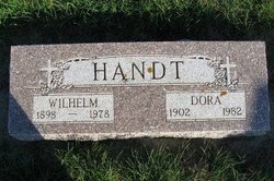
Dora Esther Wright Handt
| Birth | : | 22 Dec 1902 Floyd County, Iowa, USA |
| Death | : | 29 May 1982 Waterloo, Black Hawk County, Iowa, USA |
| Burial | : | Calvary Cemetery, Osage, Mitchell County, USA |
| Coordinate | : | 43.2238998, -92.8300018 |
| Description | : | Mitchell County Press, Wednesday, June 2, 1982 Funeral services for Dora Handt, 79, formerly of Osage, who died Saturday, May 29, 1982, at a Waterloo nursing home, were held Tuesday, June 1, at Champion Funeral Home, Osage, with the Reverend Robert B. Ward of Grace United Methodist Church, Waterloo officiating. Burial will be in Calvary Cemetery, rural Osage. |
frequently asked questions (FAQ):
-
Where is Dora Esther Wright Handt's memorial?
Dora Esther Wright Handt's memorial is located at: Calvary Cemetery, Osage, Mitchell County, USA.
-
When did Dora Esther Wright Handt death?
Dora Esther Wright Handt death on 29 May 1982 in Waterloo, Black Hawk County, Iowa, USA
-
Where are the coordinates of the Dora Esther Wright Handt's memorial?
Latitude: 43.2238998
Longitude: -92.8300018
Family Members:
Parent
Spouse
Siblings
Children
Flowers:


Nearby Cemetories:
1. Calvary Cemetery
Osage, Mitchell County, USA
Coordinate: 43.2238998, -92.8300018
2. Tucker Cemetery
Osage, Mitchell County, USA
Coordinate: 43.2494011, -92.8319016
3. Dudley Cemetery
Dudley (historical), Mitchell County, USA
Coordinate: 43.2252998, -92.8743973
4. Orchard Cemetery
Orchard, Mitchell County, USA
Coordinate: 43.2249985, -92.7838898
5. South Osage Mennonite Church Cemetery
Osage, Mitchell County, USA
Coordinate: 43.2544556, -92.7915573
6. Sacred Heart Cemetery
Osage, Mitchell County, USA
Coordinate: 43.2742004, -92.7917023
7. Eden Presbyterian Cemetery
Meroa, Mitchell County, USA
Coordinate: 43.2131004, -92.9103012
8. Osage Cemetery
Osage, Mitchell County, USA
Coordinate: 43.2916700, -92.8201700
9. Rock Creek Cemetery
Meroa, Mitchell County, USA
Coordinate: 43.2352791, -92.9225006
10. West End Cemetery
Meroa, Mitchell County, USA
Coordinate: 43.2216682, -92.9250031
11. Oak Grove Cemetery
Mitchell, Mitchell County, USA
Coordinate: 43.3156013, -92.8707962
12. Howardville Cemetery
Floyd, Floyd County, USA
Coordinate: 43.1866989, -92.7016983
13. Rudd Evergreen Cemetery
Rudd, Floyd County, USA
Coordinate: 43.1417007, -92.9214020
14. Stillwater Cemetery
Orchard, Mitchell County, USA
Coordinate: 43.2130585, -92.6780624
15. Oakwood Cemetery
Floyd, Floyd County, USA
Coordinate: 43.1178017, -92.7307968
16. Ulsterville Cemetery
Ulster Township, Floyd County, USA
Coordinate: 43.0936012, -92.8842010
17. Riverview Cemetery
Saint Ansgar, Mitchell County, USA
Coordinate: 43.3430328, -92.9220200
18. Park Cemetery
Nora Springs, Floyd County, USA
Coordinate: 43.1444016, -92.9982986
19. Saint Peters Cemetery
New Haven, Mitchell County, USA
Coordinate: 43.2858315, -92.6427765
20. Spring Grove Cemetery
Nora Springs, Floyd County, USA
Coordinate: 43.1631012, -93.0211029
21. Rock Grove Township Cemetery
Nora Springs, Floyd County, USA
Coordinate: 43.1227989, -92.9880981
22. Saint Johns Lutheran Cemetery
Rock Creek, Mitchell County, USA
Coordinate: 43.3295560, -92.9849770
23. Saint Johns Lutheran Old Cemetery
Rock Creek, Mitchell County, USA
Coordinate: 43.3313904, -92.9897232
24. Beaver Creek Cemetery
Brownville, Mitchell County, USA
Coordinate: 43.3397217, -92.6727829