
| Birth | : | 27 May 1924 Revillo, Grant County, South Dakota, USA |
| Death | : | 25 Jun 2019 Miller, Hand County, South Dakota, USA |
| Burial | : | Saint Lawrence Cemetery, Saint Lawrence, Hand County, USA |
| Coordinate | : | 44.5292015, -98.9321976 |
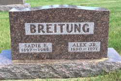
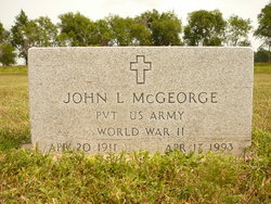
| Description | : | Doreen McGeorge Eisenbraun, 95, of Miller, went to be with her Lord Tuesday, June 25, 2019 at the Good Samaritan Center in Miller, SD. A private family graveside service will be at the St. Lawrence Cemetery. Doreen Frances was born on May 27, 1924 to Alex and Sadie (Varner) Breitung of Revillo, SD. Doreen was baptized shortly after birth and later confirmed in St. John’s Lutheran Church on May 21, 1939. Doreen married John McGeorge on June 30, 1943 and lived in the Clear Lake area for a number of years, before moving to the St.... Read More |
frequently asked questions (FAQ):
-
Where is Doreen Frances Breitung McGeorge Eisenbraun's memorial?
Doreen Frances Breitung McGeorge Eisenbraun's memorial is located at: Saint Lawrence Cemetery, Saint Lawrence, Hand County, USA.
-
When did Doreen Frances Breitung McGeorge Eisenbraun death?
Doreen Frances Breitung McGeorge Eisenbraun death on 25 Jun 2019 in Miller, Hand County, South Dakota, USA
-
Where are the coordinates of the Doreen Frances Breitung McGeorge Eisenbraun's memorial?
Latitude: 44.5292015
Longitude: -98.9321976
Family Members:
Parent

Spouse

Siblings
Flowers:


Nearby Cemetories:
1. Saint Lawrence Cemetery
Saint Lawrence, Hand County, USA
Coordinate: 44.5292015, -98.9321976
2. Saint Ann's Cemetery
Miller, Hand County, USA
Coordinate: 44.5222015, -98.9732971
3. G A R Cemetery
Miller, Hand County, USA
Coordinate: 44.5078011, -98.9858017
4. Hillcrest Cemetery
Miller, Hand County, USA
Coordinate: 44.5207000, -99.0006100
5. Beulah Cemetery
Vayland, Hand County, USA
Coordinate: 44.6060982, -98.8060989
6. Sunbeam Cemetery
Hand County, USA
Coordinate: 44.6777992, -98.8407974
7. Saint Josephs Catholic Cemetery
Hand County, USA
Coordinate: 44.4574400, -98.7100400
8. Wessington Cemetery
Hand County, USA
Coordinate: 44.4569016, -98.7102966
9. Morningside Cemetery
Ree Heights, Hand County, USA
Coordinate: 44.5147018, -99.1903000
10. Alden Cemetery
Hand County, USA
Coordinate: 44.6775017, -99.1203003
11. Burdette Cemetery
Burdette, Hand County, USA
Coordinate: 44.7002983, -98.7869034
12. McCord Cemetery
Wessington, Beadle County, USA
Coordinate: 44.3998500, -98.6673100
13. Buffalo Cemetery
Spink County, USA
Coordinate: 44.6918983, -98.6853027
14. Howell Cemetery
Miller, Hand County, USA
Coordinate: 44.7757988, -98.9766998
15. Rosehill Cemetery
Hand County, USA
Coordinate: 44.2980995, -98.7731018
16. Saint Johns Cemetery
Tulare, Spink County, USA
Coordinate: 44.7202988, -98.6600037
17. Mount Calvary Cemetery
Polo, Hand County, USA
Coordinate: 44.7827988, -99.1097031
18. Sand Creek Cemetery
Beadle County, USA
Coordinate: 44.3055800, -98.6791200
19. Garfield Cemetery
Spink County, USA
Coordinate: 44.6622009, -98.5535965
20. Ebenezer Baptist Cemetery
Hand County, USA
Coordinate: 44.2106018, -98.9056015
21. Bonilla Cemetery
Bonilla, Beadle County, USA
Coordinate: 44.5830994, -98.4835968
22. Saint Michaels Cemetery
Hand County, USA
Coordinate: 44.8302994, -99.1106033
23. Cedar Cemetery
Hand County, USA
Coordinate: 44.2775002, -99.2238998
24. New Zion Cemetery
Hand County, USA
Coordinate: 44.2043991, -98.8206024