
| Birth | : | 28 Dec 1905 Iowa, USA |
| Death | : | 11 Feb 1998 Mount Pleasant, Henry County, Iowa, USA |
| Burial | : | All Saints Churchyard, Frindsbury, Medway Unitary Authority, England |
| Coordinate | : | 51.4004440, 0.5058970 |
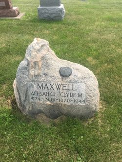
| Description | : | The Burlington Hawkeye, February 16, 1998 Doris Strothman Doris Maxwell Strothman, 92, of New London, died at 1230 p.m. Wednesday, Feb. 11, 1998, at Henry County Health Center in Mount Pleasant. Born Dec. 28, 1905, in Crawfordsville, she was the daughter of Clyde and Ashsah Smith Maxwell. On June 11, 1929, she married Charles F. Strothman in Crawfordsville. He died May 27, 1985. Mrs. Strothman graduated from Crawfordsville High School and what is now the University of Northern Iowa, Cedar Falls. She was a homemaker and country school teacher in Mount Union and Washington County. She did research for her husband,... Read More |
frequently asked questions (FAQ):
-
Where is Doris Achsah Maxwell Strothman's memorial?
Doris Achsah Maxwell Strothman's memorial is located at: All Saints Churchyard, Frindsbury, Medway Unitary Authority, England.
-
When did Doris Achsah Maxwell Strothman death?
Doris Achsah Maxwell Strothman death on 11 Feb 1998 in Mount Pleasant, Henry County, Iowa, USA
-
Where are the coordinates of the Doris Achsah Maxwell Strothman's memorial?
Latitude: 51.4004440
Longitude: 0.5058970
Family Members:
Parent

Spouse
Siblings
Children
Flowers:


Nearby Cemetories:
1. All Saints Churchyard
Frindsbury, Medway Unitary Authority, England
Coordinate: 51.4004440, 0.5058970
2. St Nicholas with St Mary Churchyard
Strood, Medway Unitary Authority, England
Coordinate: 51.3959790, 0.4931350
3. St Nicholas Churchyard
Rochester, Medway Unitary Authority, England
Coordinate: 51.3894170, 0.5035320
4. Rochester Castle Moat Burial Ground
Rochester, Medway Unitary Authority, England
Coordinate: 51.3894140, 0.5024580
5. Rochester Cathedral
Rochester, Medway Unitary Authority, England
Coordinate: 51.3889750, 0.5031160
6. Rochester Baptist Church
Rochester, Medway Unitary Authority, England
Coordinate: 51.3871570, 0.5052370
7. St Philip and St James Churchyard
Upnor, Medway Unitary Authority, England
Coordinate: 51.4106250, 0.5250480
8. St Margaret Churchyard
Rochester, Medway Unitary Authority, England
Coordinate: 51.3849380, 0.4993630
9. Brompton War Memorial
Chatham, Medway Unitary Authority, England
Coordinate: 51.3932140, 0.5293660
10. Strood Cemetery
Strood, Medway Unitary Authority, England
Coordinate: 51.3900220, 0.4838640
11. St Mary Churchyard
Chatham, Medway Unitary Authority, England
Coordinate: 51.3874550, 0.5244280
12. St George Churchyard
Chatham, Medway Unitary Authority, England
Coordinate: 51.3974070, 0.5346770
13. Chatham Unitarian Church
Chatham, Medway Unitary Authority, England
Coordinate: 51.3826090, 0.5195850
14. Chatham Burial Ground
Chatham, Medway Unitary Authority, England
Coordinate: 51.3849900, 0.5272600
15. St. Nicholas's Cemetery
Rochester, Medway Unitary Authority, England
Coordinate: 51.3780081, 0.5021076
16. St. Margaret's Cemetery
Rochester, Medway Unitary Authority, England
Coordinate: 51.3777000, 0.5011600
17. Chatham Naval Memorial
Chatham, Medway Unitary Authority, England
Coordinate: 51.3836479, 0.5321670
18. Fort Pitt Military Cemetery
Rochester, Medway Unitary Authority, England
Coordinate: 51.3769790, 0.5114570
19. St Matthew Churchyard
Borstal, Medway Unitary Authority, England
Coordinate: 51.3736150, 0.4868020
20. St John Evangelist Churchyard
Higham, Gravesham Borough, England
Coordinate: 51.4162102, 0.4616890
21. Chatham Maidstone Road Cemetery
Chatham, Medway Unitary Authority, England
Coordinate: 51.3703300, 0.5227600
22. St. Barnabas Church
Gillingham, Medway Unitary Authority, England
Coordinate: 51.3801400, 0.5505370
23. Chatham Palmerston Road Cemetery
Chatham, Medway Unitary Authority, England
Coordinate: 51.3678600, 0.5267300
24. St Mary Magdalene Churchyard
Gillingham, Medway Unitary Authority, England
Coordinate: 51.3903530, 0.5622230