

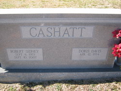
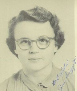
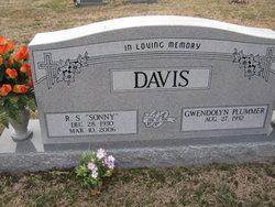
Doris Ann Davis Cashatt
| Birth | : | 12 Apr 1934 Randolph County, North Carolina, USA |
| Death | : | 5 Jun 2020 Randolph County, North Carolina, USA |
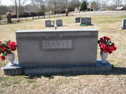
| Burial | : | Cedar Square Friends Meeting Cemetery, Randolph County, USA |
| Coordinate | : | 35.8872860, -79.8696320 |
| Description | : | Doris Ann Davis Cashatt, age 86, passed away peacefully at her home on June 5, 2020 after a brief illness. Born on April 12, 1934, Doris was the youngest daughter of Branson and Veva Davis. On April 3, 1954, she married Robert Sidney Cashatt. Mrs. Cashatt taught many children during her thirty-two years as a teacher at New Market School. She and her husband, Sidney owned and operated H & M Grocery and Hardware from 1983 – 2004. Doris was a lifetime member of Cedar Square Friends Meeting where she sang in the choir and taught... Read More |
frequently asked questions (FAQ):
-
Where is Doris Ann Davis Cashatt's memorial?
Doris Ann Davis Cashatt's memorial is located at: Cedar Square Friends Meeting Cemetery, Randolph County, USA.
-
When did Doris Ann Davis Cashatt death?
Doris Ann Davis Cashatt death on 5 Jun 2020 in Randolph County, North Carolina, USA
-
Where are the coordinates of the Doris Ann Davis Cashatt's memorial?
Latitude: 35.8872860
Longitude: -79.8696320
Family Members:
Parent

Spouse
Siblings

Children

Flowers:


Nearby Cemetories:
1. Cedar Square Friends Meeting Cemetery
Randolph County, USA
Coordinate: 35.8872860, -79.8696320
2. Galilee United Church of God Cemetery
Randleman, Randolph County, USA
Coordinate: 35.8887990, -79.8648480
3. Ebenezer United Methodist Church Cemetery
Archdale, Randolph County, USA
Coordinate: 35.9018700, -79.8760100
4. Faith Baptist Church Cemetery
Randolph County, USA
Coordinate: 35.8919040, -79.9005590
5. Glenola Baptist Church Cemetery
Archdale, Randolph County, USA
Coordinate: 35.8688390, -79.9041930
6. Glenola Community Cemetery
Glenola, Randolph County, USA
Coordinate: 35.8687190, -79.9052570
7. Bethel United Methodist Church Cemetery
Archdale, Randolph County, USA
Coordinate: 35.8707360, -79.9104050
8. Shady Grove Baptist Church Cemetery
Randolph County, USA
Coordinate: 35.8673020, -79.9154950
9. Fairfield United Methodist Church Cemetery
High Point, Guilford County, USA
Coordinate: 35.9208200, -79.9076600
10. Bell Welborn Cemetery
Randolph County, USA
Coordinate: 35.8400950, -79.8515080
11. Level Cross Baptist Church Cemetery
Randleman, Randolph County, USA
Coordinate: 35.8879530, -79.8081950
12. Marlboro Friends Meeting Cemetery
Sophia, Randolph County, USA
Coordinate: 35.8391650, -79.8854900
13. Guil-Rand Memorial Park
High Point, Guilford County, USA
Coordinate: 35.9218254, -79.9157677
14. Level Cross United Methodist Church Cemetery
Randleman, Randolph County, USA
Coordinate: 35.8871100, -79.8066620
15. Old Union United Methodist Church Cemetery
Sophia, Randolph County, USA
Coordinate: 35.8345500, -79.8571860
16. Mount Vernon United Methodist Church Cemetery
Trinity, Randolph County, USA
Coordinate: 35.8593270, -79.9372480
17. Centre Friends Meeting Cemetery
Greensboro, Guilford County, USA
Coordinate: 35.9212000, -79.8014000
18. Saint Peters UMC Cemetery
Randleman, Randolph County, USA
Coordinate: 35.8601310, -79.7956760
19. Saint Peter United Methodist Church Cemetery
Randleman Township, Randolph County, USA
Coordinate: 35.8601570, -79.7956300
20. Burnetts Chapel United Methodist Church Cemetery
Greensboro, Guilford County, USA
Coordinate: 35.9454800, -79.8276920
21. Community Baptist Church Cemetery
Greensboro, Guilford County, USA
Coordinate: 35.9548060, -79.8481770
22. Branson Mill Baptist Church Cemetery
Randolph County, USA
Coordinate: 35.9062540, -79.7822510
23. Mount Olive Wesleyan Church Cemetery
Sophia, Randolph County, USA
Coordinate: 35.8228920, -79.9131380
24. Trinity Holiness Church Cemetery
Sophia, Randolph County, USA
Coordinate: 35.8146050, -79.8427561