
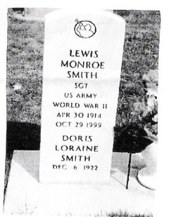
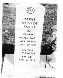
Doris Loriane Saxton Smith
| Birth | : | 6 Dec 1922 Alliance, Box Butte County, Nebraska, USA |
| Death | : | 12 May 2008 Alliance, Box Butte County, Nebraska, USA |
| Burial | : | West Cemetery, Shutesbury, Franklin County, USA |
| Coordinate | : | 42.4502300, -72.4242700 |
| Plot | : | Block 8 Sec. 2 |
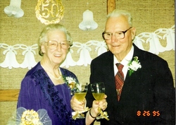
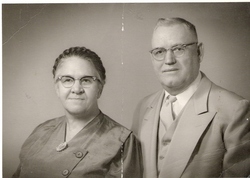
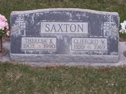
| Description | : | Doris is the oldest child of Clifford & Theresa (Lux) Saxton. She married Lewis Smith Aug 22, 1945 in California. There she raised her 3 children. She went back to Nebraska to care for her ailing mother in the late 1970's. Doris loved to cook and eat good food. She and my aunt taught me my love for crochet. She was a wealth of knowledge, when she could remember it. As she got older it just go harder on her to remember. She sure knew a lot of stuff though! *I omitted last names of family and cities they live in... Read More |
frequently asked questions (FAQ):
-
Where is Doris Loriane Saxton Smith's memorial?
Doris Loriane Saxton Smith's memorial is located at: West Cemetery, Shutesbury, Franklin County, USA.
-
When did Doris Loriane Saxton Smith death?
Doris Loriane Saxton Smith death on 12 May 2008 in Alliance, Box Butte County, Nebraska, USA
-
Where are the coordinates of the Doris Loriane Saxton Smith's memorial?
Latitude: 42.4502300
Longitude: -72.4242700
Family Members:
Parent
Spouse
Siblings
Flowers:


Nearby Cemetories:
1. West Cemetery
Shutesbury, Franklin County, USA
Coordinate: 42.4502300, -72.4242700
2. Luther Henry Tomb Yard
Shutesbury, Franklin County, USA
Coordinate: 42.4501500, -72.4253400
3. Jewish Community Association of Amherst Cemetery
Shutesbury, Franklin County, USA
Coordinate: 42.4502690, -72.4297230
4. Pratts Corner Cemetery
Shutesbury, Franklin County, USA
Coordinate: 42.4183400, -72.4700500
5. East Leverett Cemetery
Leverett, Franklin County, USA
Coordinate: 42.4357224, -72.4857788
6. Locks Village Cemetery
Shutesbury, Franklin County, USA
Coordinate: 42.5010200, -72.4364000
7. Moores Corner Cemetery
Leverett, Franklin County, USA
Coordinate: 42.4924200, -72.4730700
8. Patrick Cemetery
Leverett, Franklin County, USA
Coordinate: 42.4995800, -72.4619500
9. North Cemetery
Leverett, Franklin County, USA
Coordinate: 42.4673720, -72.4983230
10. Gardner Cemetery
Leverett, Franklin County, USA
Coordinate: 42.5036011, -72.4574966
11. South Cemetery
Wendell, Franklin County, USA
Coordinate: 42.5092000, -72.4206000
12. Mountain View Cemetery
New Salem, Franklin County, USA
Coordinate: 42.4561005, -72.3443985
13. Pelham Hill Cemetery
Pelham, Hampshire County, USA
Coordinate: 42.3927400, -72.4040900
14. Plain View Cemetery
Leverett, Franklin County, USA
Coordinate: 42.4972100, -72.4751900
15. Town House Cemetery (Defunct)
Prescott, Hampshire County, USA
Coordinate: 42.4175300, -72.3548800
16. West Burial Ground
Pelham, Hampshire County, USA
Coordinate: 42.3889480, -72.4279690
17. North Valley Cemetery
Pelham, Hampshire County, USA
Coordinate: 42.3874590, -72.4425120
18. Valley Cemetery
Pelham, Hampshire County, USA
Coordinate: 42.3871994, -72.4439011
19. Arnold Burial Ground
Pelham, Hampshire County, USA
Coordinate: 42.3791850, -72.4405430
20. Long Plain Cemetery
Leverett, Franklin County, USA
Coordinate: 42.4510994, -72.5250015
21. Quaker Burying Ground
Pelham, Hampshire County, USA
Coordinate: 42.3764000, -72.4424200
22. Harkness Cemetery
Pelham, Hampshire County, USA
Coordinate: 42.3777700, -72.4627300
23. North Cemetery
Amherst, Hampshire County, USA
Coordinate: 42.4082985, -72.5132980
24. Mount Hope Cemetery
Leverett, Franklin County, USA
Coordinate: 42.5111008, -72.4906006