
| Birth | : | 24 Nov 1929 Milton, Cabell County, West Virginia, USA |
| Death | : | 21 Mar 2017 Camden, Camden County, New Jersey, USA |
| Burial | : | Laurel Lawn Cemetery, Upper Deerfield Township, Cumberland County, USA |
| Coordinate | : | 39.4602930, -75.2292470 |
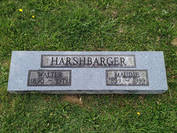
| Description | : | Dorla A. Erianne (nee Harshbarger), 87, of Upper Deerfield Township died tragically Tuesday afternoon March 21, 2017 at Cooper Hospital/University Medical Center in Camden as a result of injuries sustained in an automobile accident. Dorla was born and raised in Milton, WV. She was the daughter of the late Walter and Maude Baylous Harshbarger and graduated from Milton High School in 1947. She also attended Marshall College (now University) for two years until entering the United States Air Force. Dorla served honorably during the Korean Conflict and was discharged in 1952 as a Staff Sergeant. She moved to Southern New Jersey to... Read More |
frequently asked questions (FAQ):
-
Where is Dorla Ann Harshbarger Erianne's memorial?
Dorla Ann Harshbarger Erianne's memorial is located at: Laurel Lawn Cemetery, Upper Deerfield Township, Cumberland County, USA.
-
When did Dorla Ann Harshbarger Erianne death?
Dorla Ann Harshbarger Erianne death on 21 Mar 2017 in Camden, Camden County, New Jersey, USA
-
Where are the coordinates of the Dorla Ann Harshbarger Erianne's memorial?
Latitude: 39.4602930
Longitude: -75.2292470
Family Members:
Parent

Spouse

Siblings
Children
Flowers:


Nearby Cemetories:
1. Laurel Lawn Cemetery
Upper Deerfield Township, Cumberland County, USA
Coordinate: 39.4602930, -75.2292470
2. Saint Marys Cemetery
Bridgeton, Cumberland County, USA
Coordinate: 39.4403992, -75.2252274
3. Cohanzick Zoo
Bridgeton, Cumberland County, USA
Coordinate: 39.4395510, -75.2388370
4. First Baptist Church Cemetery
Bridgeton, Cumberland County, USA
Coordinate: 39.4325638, -75.2298355
5. First United Methodist Churchyard
Bridgeton, Cumberland County, USA
Coordinate: 39.4282417, -75.2277298
6. Old Broad Street Presbyterian Church Cemetery
Bridgeton, Cumberland County, USA
Coordinate: 39.4295235, -75.2457123
7. Woodruff United Methodist Church Cemetery
Woodruff, Cumberland County, USA
Coordinate: 39.4699516, -75.1877289
8. Friendship Finley Methodist Church Cemetery
Bridgeton, Cumberland County, USA
Coordinate: 39.4835472, -75.1940002
9. Overlook Cemetery
Bridgeton, Cumberland County, USA
Coordinate: 39.4239006, -75.2536011
10. Fernwood Memorial Park
Bridgeton, Cumberland County, USA
Coordinate: 39.4514008, -75.2844009
11. Cedar Hill Memorial Park
Bridgeton, Cumberland County, USA
Coordinate: 39.4244003, -75.2647018
12. Northville Estonian Lutheran Church Cemetery
Bridgeton, Cumberland County, USA
Coordinate: 39.5048890, -75.2039760
13. Shiloh Seventh Day Baptist Church Cemetery
Shiloh, Cumberland County, USA
Coordinate: 39.4591293, -75.2956696
14. Deerfield Presbyterian Cemetery
Deerfield, Cumberland County, USA
Coordinate: 39.5117000, -75.2375900
15. Gouldtown Memorial Park
Gouldtown, Cumberland County, USA
Coordinate: 39.4199170, -75.1858060
16. Cumberland County Memorial Cemetery
Bridgeton, Cumberland County, USA
Coordinate: 39.4125600, -75.2638800
17. Cumberland County Veterans Cemetery
Bridgeton, Cumberland County, USA
Coordinate: 39.4105186, -75.2588959
18. Fordville Memorial Cemetery
Bridgeton, Cumberland County, USA
Coordinate: 39.4265840, -75.1713430
19. Deerfield United Methodist Church Cemetery
Deerfield, Cumberland County, USA
Coordinate: 39.5258700, -75.2361200
20. Cohansey Baptist Church Cemetery
Roadstown, Cumberland County, USA
Coordinate: 39.4388630, -75.3143070
21. German Presbyterian Church Graveyard
Hopewell Township, Cumberland County, USA
Coordinate: 39.5144000, -75.2884060
22. Beth Abraham Memorial Park
Rosenhayn, Cumberland County, USA
Coordinate: 39.4699211, -75.1374817
23. Mount Hope Cemetery
Rosenhayn, Cumberland County, USA
Coordinate: 39.4667600, -75.1299200
24. Saint Marys Cemetery
Rosenhayn, Cumberland County, USA
Coordinate: 39.4659500, -75.1295800