
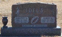
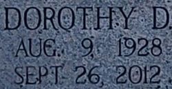
Dorothy D. Harms Ideus
| Birth | : | 9 Aug 1928 Beatrice, Gage County, Nebraska, USA |
| Death | : | 26 Sep 2012 Beatrice, Gage County, Nebraska, USA |
| Burial | : | Highland Cemetery, Adams, Gage County, USA |
| Coordinate | : | 40.4580994, -96.5196991 |
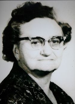
| Description | : | Dorothy D. Ideus, 84, of Adams, died on Wednesday evening, Sept. 26, 2012, at Gold Crest Retirement Center in Adams. She was born on Aug. 9, 1928, at rural Adams and was confirmed at the American Lutheran Church of Adams. She attended Coffman Country School. On April 11, 1948, she married Albert Ideus at the American Lutheran Church of Adams, and they lived and worked a dairy farm near Cortland for over 60 years. They moved to Adams in 2008. She was a member of the American Lutheran Church of Adams, where she taught Sunday School and had been a Luther League... Read More |
frequently asked questions (FAQ):
-
Where is Dorothy D. Harms Ideus's memorial?
Dorothy D. Harms Ideus's memorial is located at: Highland Cemetery, Adams, Gage County, USA.
-
When did Dorothy D. Harms Ideus death?
Dorothy D. Harms Ideus death on 26 Sep 2012 in Beatrice, Gage County, Nebraska, USA
-
Where are the coordinates of the Dorothy D. Harms Ideus's memorial?
Latitude: 40.4580994
Longitude: -96.5196991
Family Members:
Parent
Spouse

Siblings

Flowers:


Nearby Cemetories:
1. Highland Cemetery
Adams, Gage County, USA
Coordinate: 40.4580994, -96.5196991
2. Hooker Cemetery
Adams, Gage County, USA
Coordinate: 40.4207993, -96.4732971
3. Grandview Cemetery
Gage County, USA
Coordinate: 40.4617004, -96.6091995
4. Granite Hill Cemetery
Johnson County, USA
Coordinate: 40.4180984, -96.4417038
5. Immanuel Cemetery
Sterling, Johnson County, USA
Coordinate: 40.4692001, -96.4253006
6. Latrobe Cemetery
Sterling, Johnson County, USA
Coordinate: 40.5151000, -96.4557000
7. Weber Cemetery
Sterling, Johnson County, USA
Coordinate: 40.4581000, -96.4177000
8. Saint Johns Lutheran Cemetery
Cortland, Gage County, USA
Coordinate: 40.5078300, -96.6252700
9. Firth Cemetery
Firth, Lancaster County, USA
Coordinate: 40.5250015, -96.6085968
10. Pella Cemetery
Panama, Lancaster County, USA
Coordinate: 40.5555992, -96.5014038
11. Saint John North Lutheran Cemetery
Sterling, Johnson County, USA
Coordinate: 40.4689500, -96.3878500
12. Sunnyside Cemetery
Cortland, Gage County, USA
Coordinate: 40.4799200, -96.6511800
13. South Saint John Lutheran Cemetery
Sterling, Johnson County, USA
Coordinate: 40.4355500, -96.3858000
14. Dietz Cemetery
Firth, Lancaster County, USA
Coordinate: 40.5449982, -96.6286011
15. Sterling Cemetery
Sterling, Johnson County, USA
Coordinate: 40.4585991, -96.3582993
16. Panama Cemetery
Panama, Lancaster County, USA
Coordinate: 40.5821991, -96.5255966
17. Zion Evangelical Lutheran Cemetery
Pickrell, Gage County, USA
Coordinate: 40.3456001, -96.6147003
18. Christ Lutheran Church Cemetery
Pickrell, Gage County, USA
Coordinate: 40.4079410, -96.6848370
19. Saint James Cemetery
Cortland, Gage County, USA
Coordinate: 40.4886050, -96.7036050
20. Cortland Cemetery
Cortland, Gage County, USA
Coordinate: 40.4879200, -96.7041250
21. Crab Orchard Cemetery
Crab Orchard, Johnson County, USA
Coordinate: 40.3274994, -96.4366989
22. Solon Cemetery
Otoe County, USA
Coordinate: 40.5917015, -96.4436035
23. Holland Cemetery
Holland, Lancaster County, USA
Coordinate: 40.5957985, -96.5997009
24. Rosehill Cemetery
Douglas, Otoe County, USA
Coordinate: 40.5845940, -96.3867900