
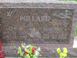
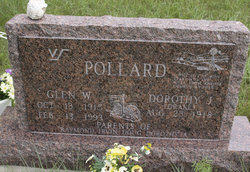
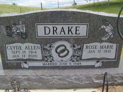
Dorothy Drake Pollard
| Birth | : | 23 Apr 1918 Loup County, Nebraska, USA |
| Death | : | 20 Mar 2012 Ord, Valley County, Nebraska, USA |
| Burial | : | Moulton Cemetery, Loup County, USA |
| Coordinate | : | 41.8574982, -99.5852966 |
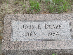
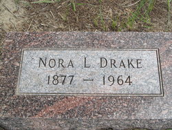
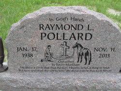
| Description | : | Dorothy (Drake) Pollard, 93, formerly of Milburn area, died Tuesday, March 20, 2012, at Valley County Hospital in Ord. Dorothy was born Aug. 23, 1918, in Loup County near Almeria to John Edward and Nora Lee (Hess) Drake. On May 27, 1937, she was married to Glen Pollard. He preceded her in death. Survivors are: daughter Dorothy Anderson of Holdrege and Tim Anderson of Plum Creek; sons and daughters-in-law, Raymond Pollard of Oklahoma, Irvin and Joan Pollard of Monument, Colo., and Douglas and Kathy Pollard of Taylor; 18 grandchildren, 27 great-grandchildren, and six great-great-grandchildren; a sister-in-law, Rosie Drake of Sargent. Burial was... Read More |
frequently asked questions (FAQ):
-
Where is Dorothy Drake Pollard's memorial?
Dorothy Drake Pollard's memorial is located at: Moulton Cemetery, Loup County, USA.
-
When did Dorothy Drake Pollard death?
Dorothy Drake Pollard death on 20 Mar 2012 in Ord, Valley County, Nebraska, USA
-
Where are the coordinates of the Dorothy Drake Pollard's memorial?
Latitude: 41.8574982
Longitude: -99.5852966
Family Members:
Parent
Spouse
Siblings

Children
Flowers:


Nearby Cemetories:
1. Moulton Cemetery
Loup County, USA
Coordinate: 41.8574982, -99.5852966
2. Almeria Cemetery
Almeria, Loup County, USA
Coordinate: 41.8177986, -99.5128021
3. Madison Square Cemetery
Taylor, Loup County, USA
Coordinate: 41.7694016, -99.5314026
4. Taylor Cemetery
Taylor, Loup County, USA
Coordinate: 41.7571983, -99.3861008
5. Predmore Cemetery
Walworth, Custer County, USA
Coordinate: 41.6755981, -99.5674973
6. West Union Cemetery
Sargent, Custer County, USA
Coordinate: 41.6763992, -99.4608002
7. Brewster Cemetery
Brewster, Blaine County, USA
Coordinate: 41.9291992, -99.8419037
8. Gates Cemetery
Gates, Custer County, USA
Coordinate: 41.6492004, -99.6361008
9. Saint Marys Cemetery
Sargent, Custer County, USA
Coordinate: 41.6768990, -99.4044037
10. Mount Hope Cemetery
Sargent, Custer County, USA
Coordinate: 41.6768990, -99.3855972
11. Kent Cemetery
Taylor, Loup County, USA
Coordinate: 41.7416992, -99.3088989
12. German Valley Cemetery
Blaine County, USA
Coordinate: 42.0116997, -99.8313980
13. Victoria Creek Cemetery
Anselmo, Custer County, USA
Coordinate: 41.6255000, -99.7510000
14. Lillian Cemetery
Lillian, Custer County, USA
Coordinate: 41.5925000, -99.6500000
15. Round Valley Cemetery
Custer County, USA
Coordinate: 41.5758018, -99.5180969
16. Somerford Cemetery
Sargent, Custer County, USA
Coordinate: 41.5793991, -99.4328003
17. Jack Shafer Memorial Cemetery
Burwell, Garfield County, USA
Coordinate: 41.8202200, -99.1835500
18. Parker Cemetery
Burwell, Garfield County, USA
Coordinate: 41.8203011, -99.1821976
19. Saint Anselms Cemetery
Anselmo, Custer County, USA
Coordinate: 41.6157990, -99.8442001
20. New Hope Cemetery
Merna, Custer County, USA
Coordinate: 41.5772018, -99.7833023
21. Grandview Cemetery
Anselmo, Custer County, USA
Coordinate: 41.6255962, -99.8944652
22. Littlefield Cemetery
Burwell, Garfield County, USA
Coordinate: 41.8093987, -99.1389008
23. Cottonwood Cemetery
Burwell, Garfield County, USA
Coordinate: 41.7681007, -99.1418991
24. Duff Cemetery
Duff, Rock County, USA
Coordinate: 42.2028008, -99.5935974