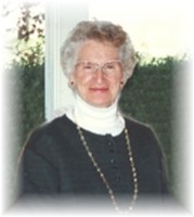
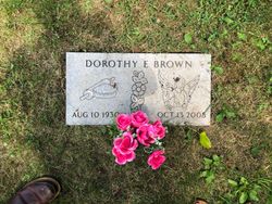
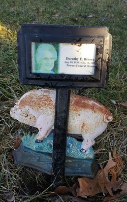
Dorothy Elaine Finger Brown
| Birth | : | 10 Aug 1930 North Dakota, USA |
| Death | : | 13 Oct 2008 Iowa, USA |
| Burial | : | Fairview Cemetery, Keedysville, Washington County, USA |
| Coordinate | : | 39.4882200, -77.7023600 |
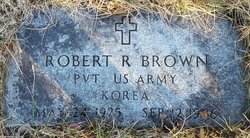
| Description | : | Dorothy E. Brown, 78, of rural Thayer died Oct. 13, 2008, at Afton Care Center. Services will be 2 p.m. Friday, Oct. 17, at Powers Funeral Home, junction of Highways 34 and 25. The Rev. Jim Morris will officiate. Burial will be in Browns Mountain Cemetery in rural Thayer. Dorothy Elaine Brown was born August 10, 1930 in Butte, N.D. to Frances Elizabeth (Schafer) and George Roland Finger. She graduated from Jefferson High School in Daly City, Calif. On Feb. 26, 1950, Dorothy married Robert Roman Brown in St. Maries, Idaho. In 1955, they moved to Union County, residing in Creston,... Read More |
frequently asked questions (FAQ):
-
Where is Dorothy Elaine Finger Brown's memorial?
Dorothy Elaine Finger Brown's memorial is located at: Fairview Cemetery, Keedysville, Washington County, USA.
-
When did Dorothy Elaine Finger Brown death?
Dorothy Elaine Finger Brown death on 13 Oct 2008 in Iowa, USA
-
Where are the coordinates of the Dorothy Elaine Finger Brown's memorial?
Latitude: 39.4882200
Longitude: -77.7023600
Family Members:
Spouse
Children
Flowers:
Nearby Cemetories:
1. Fairview Cemetery
Keedysville, Washington County, USA
Coordinate: 39.4882200, -77.7023600
2. Mount Hebron Cemetery
Keedysville, Washington County, USA
Coordinate: 39.4824982, -77.6900024
3. Red Hill Cemetery
Keedysville, Washington County, USA
Coordinate: 39.4700100, -77.6989400
4. Mumma Cemetery
Sharpsburg, Washington County, USA
Coordinate: 39.4780000, -77.7421900
5. Antietam National Battlefield
Sharpsburg, Washington County, USA
Coordinate: 39.4742126, -77.7445374
6. Mount Carmel Church Cemetery
Keedysville, Washington County, USA
Coordinate: 39.4724998, -77.6564026
7. Snyder Farm Cemetery
Boonsboro, Washington County, USA
Coordinate: 39.4641300, -77.6618000
8. Trinity Reformed United Church of Christ Cemetery
Boonsboro, Washington County, USA
Coordinate: 39.5058300, -77.6542800
9. Old Salem Church Cemetery
Boonsboro, Washington County, USA
Coordinate: 39.5062590, -77.6543710
10. Mountain View Cemetery
Sharpsburg, Washington County, USA
Coordinate: 39.4604800, -77.7419500
11. Antietam National Cemetery
Sharpsburg, Washington County, USA
Coordinate: 39.4601400, -77.7417700
12. Boonsboro Cemetery
Boonsboro, Washington County, USA
Coordinate: 39.5045100, -77.6524700
13. Mount Calvary Lutheran Cemetery
Sharpsburg, Washington County, USA
Coordinate: 39.4591751, -77.7432175
14. Abraham Lemaster Gravesite
Boonsboro, Washington County, USA
Coordinate: 39.5084763, -77.6521835
15. Emmert Graveyard
Tilghmanton, Washington County, USA
Coordinate: 39.5265850, -77.7306050
16. Manor Church of the Brethren Cemetery
Tilghmanton, Washington County, USA
Coordinate: 39.5285988, -77.7264023
17. Sharpsburg Reformed Cemetery
Sharpsburg, Washington County, USA
Coordinate: 39.4595900, -77.7486700
18. Tolsons Chapel Cemetery
Sharpsburg, Washington County, USA
Coordinate: 39.4561900, -77.7463700
19. Mount Briar Cemetery
Washington County, USA
Coordinate: 39.4427986, -77.6864014
20. Salem Lutheran Church Cemetery
Bakersville, Washington County, USA
Coordinate: 39.5135680, -77.7559970
21. First Methodist Cemetery
Sharpsburg, Washington County, USA
Coordinate: 39.4581500, -77.7521700
22. Mount Zion Lutheran Church Cemetery
Locust Grove, Washington County, USA
Coordinate: 39.4478760, -77.6637726
23. Zittlestown Church of God Cemetery
Zittlestown, Washington County, USA
Coordinate: 39.4878300, -77.6269200
24. Benevola United Methodist Church Cemetery
Benevola, Washington County, USA
Coordinate: 39.5452000, -77.6745000

