
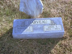
Dorothy Florence Liberty Darveau
| Birth | : | 2 Mar 1912 |
| Death | : | 26 May 1998 Falls City, Richardson County, Nebraska, USA |
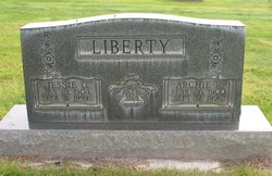
| Burial | : | Bayard Cemetery, Bayard, Grant County, USA |
| Coordinate | : | 39.2728004, -79.3447037 |
| Description | : | Dorothy Florence Liberty was born March 2, 1912 to Abe Liberty and Eva Johnson Liberty. She married Louis Eugene Darveau January 18, 1928, in Mercer, Kansas. Dorothy F. Darveau, 86, a resident of Midland Villa in Falls City, died Tuesday, May 26, 1998, at Community Medical Center. She was born March 2, 1912, in Rulo, a daughter of Abraham Liberty and Eva Johnson Liberty. She attended school in Rulo. She married Louis Eugene Darveau in January 1928 at Mercier, Kan. He died Dec. 22, 1965. Mrs. Darveau lived in the Rulo and Falls City areas all her life. She was a member of Sts.... Read More |
frequently asked questions (FAQ):
-
Where is Dorothy Florence Liberty Darveau's memorial?
Dorothy Florence Liberty Darveau's memorial is located at: Bayard Cemetery, Bayard, Grant County, USA.
-
When did Dorothy Florence Liberty Darveau death?
Dorothy Florence Liberty Darveau death on 26 May 1998 in Falls City, Richardson County, Nebraska, USA
-
Where are the coordinates of the Dorothy Florence Liberty Darveau's memorial?
Latitude: 39.2728004
Longitude: -79.3447037
Family Members:
Parent
Spouse
Siblings

Children
Flowers:


Nearby Cemetories:
1. Bayard Cemetery
Bayard, Grant County, USA
Coordinate: 39.2728004, -79.3447037
2. Old Bayard Cemetery
Grant County, USA
Coordinate: 39.2776740, -79.3435850
3. Pope Cemetery
Gorman, Garrett County, USA
Coordinate: 39.2870120, -79.3473470
4. Moreland Cemetery
Garrett County, USA
Coordinate: 39.2952995, -79.3703003
5. Oak Grove Cemetery
Gorman, Garrett County, USA
Coordinate: 39.3147011, -79.3531036
6. Chisholm-Nydegger Cemetery
Garrett County, USA
Coordinate: 39.3189011, -79.3403015
7. Baker Family Cemetery
Mount Storm, Grant County, USA
Coordinate: 39.2448840, -79.2968270
8. Fairview Cemetery
Oakland, Garrett County, USA
Coordinate: 39.2703018, -79.4124985
9. Alkire Cemetery
Mount Storm, Grant County, USA
Coordinate: 39.2642890, -79.2695500
10. Lish Cemetery
Garrett County, USA
Coordinate: 39.3347015, -79.3561020
11. Dobbin Cemetery
Garrett County, USA
Coordinate: 39.2421425, -79.4159961
12. James M Wilkins Cemetery
Dobbin, Grant County, USA
Coordinate: 39.2388734, -79.4154218
13. Helmick
Dobbin, Grant County, USA
Coordinate: 39.2379970, -79.4156120
14. Harvey-Wilson Cemetery
Garrett County, USA
Coordinate: 39.3325005, -79.3114014
15. Thompson Cemetery
Oakland, Garrett County, USA
Coordinate: 39.3386100, -79.3184700
16. Beckman Cemetery
Garrett County, USA
Coordinate: 39.3293991, -79.4000015
17. White Church Community Cemetery
Kearney, Garrett County, USA
Coordinate: 39.3427100, -79.3199400
18. White Cemetery
Oakland, Garrett County, USA
Coordinate: 39.3557700, -79.3277900
19. Locust Grove Cemetery
Mount Storm, Grant County, USA
Coordinate: 39.2294300, -79.2451590
20. Schaeffer Cemetery
Grant County, USA
Coordinate: 39.2607994, -79.2311020
21. Schlabach Cemetery
Gortner, Garrett County, USA
Coordinate: 39.3482800, -79.4117000
22. Saint Johns Lutheran Church Cemetery
Redhouse, Garrett County, USA
Coordinate: 39.3101501, -79.4530029
23. Tasker Family Cemetery
Oakland, Garrett County, USA
Coordinate: 39.3611900, -79.2986500
24. Moreland Cemetery
Bismarck, Grant County, USA
Coordinate: 39.2145330, -79.2467020