| Birth | : | 30 Aug 1925 Union County, South Carolina, USA |
| Death | : | 7 Nov 2004 Spartanburg County, South Carolina, USA |
| Burial | : | Westlawn-Hillcrest Memorial Park, Omaha, Douglas County, USA |
| Coordinate | : | 41.2346992, -95.9966965 |
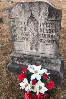
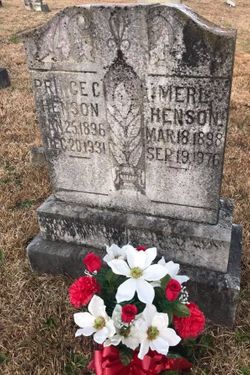
| Description | : | Dorothy Henson Crocker, 79, of 1508 Berry Farm Road, Union, wife of Herman Crocker, died Sunday, Nov. 7, 2004, at Spartanburg Regional Healthcare Center after a brief illness. A native of Union County, she was the daughter of the late Prince and Merle Grist Henson. Mrs. Crocker was employed as the bookkeeper at the Eagle Grocery Co. for 40 years, worked with the S.C. DHEC in Home Health Services as an administrative assistant for 12 yeas and was a clerical worker for Dr. Millie Schumpert at her Union office. Mrs. Crocker also taught the Faye Teague Sunday... Read More |
frequently asked questions (FAQ):
-
Where is Dorothy Henson Crocker's memorial?
Dorothy Henson Crocker's memorial is located at: Westlawn-Hillcrest Memorial Park, Omaha, Douglas County, USA.
-
When did Dorothy Henson Crocker death?
Dorothy Henson Crocker death on 7 Nov 2004 in Spartanburg County, South Carolina, USA
-
Where are the coordinates of the Dorothy Henson Crocker's memorial?
Latitude: 41.2346992
Longitude: -95.9966965
Family Members:
Parent
Spouse
Siblings
Flowers:
Nearby Cemetories:
1. Westlawn-Hillcrest Memorial Park
Omaha, Douglas County, USA
Coordinate: 41.2346992, -95.9966965
2. Bohemian Cemetery
Omaha, Douglas County, USA
Coordinate: 41.2388992, -95.9955978
3. Ak-Sar-Ben Racetrack Grounds
Omaha, Douglas County, USA
Coordinate: 41.2414703, -96.0159607
4. Douglas County Poor Farm Cemetery
Omaha, Douglas County, USA
Coordinate: 41.2437240, -95.9723480
5. Holy Sepulchre Cemetery
Omaha, Douglas County, USA
Coordinate: 41.2543983, -95.9875031
6. Calvary Cemetery
Omaha, Douglas County, USA
Coordinate: 41.2364006, -96.0294037
7. Graceland Park Cemetery
Omaha, Douglas County, USA
Coordinate: 41.2113991, -95.9785995
8. Evergreen Memorial Park Cemetery
Omaha, Douglas County, USA
Coordinate: 41.2393990, -96.0355988
9. Resurrection Cemetery
Omaha, Douglas County, USA
Coordinate: 41.2344208, -96.0365448
10. First Central Congregational Columbarium
Omaha, Douglas County, USA
Coordinate: 41.2563456, -95.9658365
11. Saint Mary Magdalene Cemetery
Omaha, Douglas County, USA
Coordinate: 41.2039420, -95.9850610
12. Nash Chapel Crypt
Omaha, Douglas County, USA
Coordinate: 41.2665090, -95.9721790
13. Saint Andrews Episcopal Church Columbarium
Omaha, Douglas County, USA
Coordinate: 41.2492500, -96.0427500
14. Saint Mary's Cemetery
Omaha, Douglas County, USA
Coordinate: 41.2042007, -95.9646988
15. Beth El Cemetery
Ralston, Douglas County, USA
Coordinate: 41.2117004, -96.0428009
16. Countryside Community Church Columbarium
Omaha, Douglas County, USA
Coordinate: 41.2483660, -96.0500270
17. Trinity Cathedral Columbarium
Omaha, Douglas County, USA
Coordinate: 41.2603900, -95.9393660
18. Prospect Hill Cemetery
Omaha, Douglas County, USA
Coordinate: 41.2780991, -95.9593964
19. Saint Johns Cemetery
Bellevue, Sarpy County, USA
Coordinate: 41.1864014, -95.9682999
20. Laurel Hill Cemetery
Omaha, Douglas County, USA
Coordinate: 41.1918983, -95.9417038
21. All Saints Episcopal Church Columbarium
Omaha, Douglas County, USA
Coordinate: 41.2785000, -96.0579000
22. Fisher Farm Cemetery
Bellevue, Sarpy County, USA
Coordinate: 41.1727982, -95.9760971
23. Hrabik Cemetery
Bellevue, Sarpy County, USA
Coordinate: 41.1726540, -95.9768200
24. Papillion Cemetery
Papillion, Sarpy County, USA
Coordinate: 41.1758003, -96.0410995

